Sacramento, Placer, Nevada Railroad Map 1861
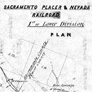
This map depicts the Sacramento, Placer and Nevada Railroad location as proposed in 1861. The map indicates an original alignment and the final grade which was in a different location. The final rail road grade is the line that traveled northwest by Rose Springs and then followed Miner’s Ravine Creek. It’s interesting that the original … Continue reading Sacramento, Placer, Nevada Railroad Map 1861
0 Comments