

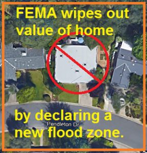
FEMA wipes out value of home in Granite Bay by declaring a new flood zone on the property.
The Federal Emergency Management Agency (FEMA) in cooperation with Placer County have released new flood hazard maps and my house is right in the middle of the floodway. According to the preliminary maps, my house never should have been built and I will be required to secure flood insurance if the preliminary flood maps are approved and become effective in June 2017. The new flood maps put the kiss of death on my ability to ever sell my house, my investment, my future. Thank you FEMA and Placer County.
Granite Bay flooding
We have known our property and home was prone to high water events shortly after we bought the home in 2003. In 2005 there was a significant precipitation downpour in the area and Linda Creek could not be contained in the stormwater system and flowed down the street and around our house. Fortunately, water surrounded the house but did not get inside. After this event the neighbors informed us that our house had flooded before. No flooding events were ever disclosed to us before we bought the home. The neighbors told us that Linda Creek will routinely overwhelmed the stormwater system that was engineered to contain it, swamping yards and occasionally entering homes.
I bought flood insurance
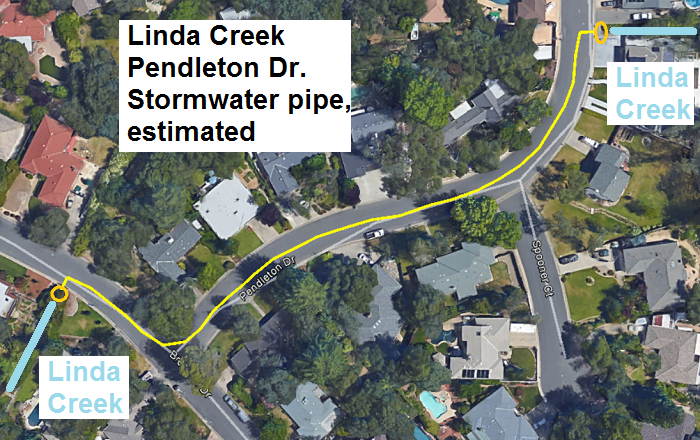
After the first high water event we purchased flood insurance. We received the preferred rating because we were not in any known flood zone. Since 2005, there have been two more high water events and neither have gotten into the house. We have actually changed our landscaping to direct any high water around the side of the house, into the backyard which is lower in elevation. The backyard was the original Linda Creek bed before the developers directed Linda Creek to the east of our house into the stormwater system. The underground stormwater pipe discharges the flow from Linda Creek, and surface water from the streets, into the wide Linda Creek channel to the west of our house.
Can I sell my home?
While I’m not happy about the high water events, I felt protected with the new landscaping to direct the water into the back coupled with flood insurance in case a 500 year downpour occurred. Unlike the previous owner, I fully intended to disclose the high water events and that we had purchased flood insurance. Even if I could not realize a resale price comparable to my neighbors who never have high water events, I felt as if our home was a decent investment for the future.
FEMA wipes out value with the new flood hazard maps
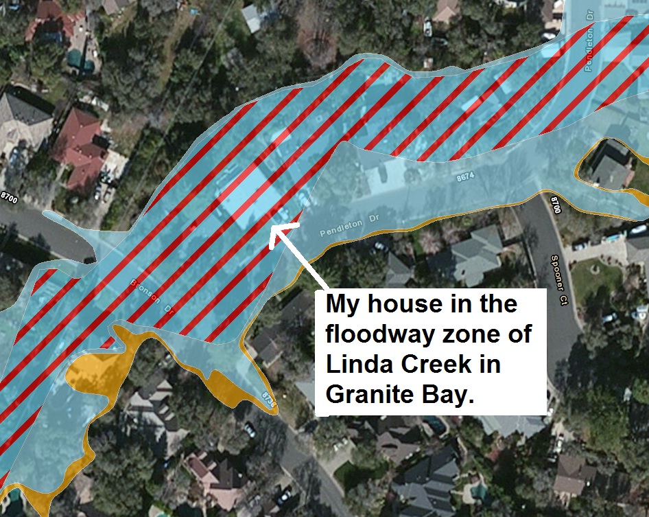
FEMA has now destroyed all current and future value our home may have had. They have deemed that our house sits in a regulatory floodway. A regulatory floodway is a designation which means nothing should ever be built on the land that might impede water flow. But beyond the possibility of never being able to rebuild the house after a flood, who in the hell would ever want to buy this house. It has FEMA red lines going through it on a flood map. It must be disclosed to any future buyer that it sits in a FEMA regulatory floodway. I may as well have a flashing neon sign over the property that warns people not to buy the house.

Like an idiot, I have tried to maintain my property. Last year we took out a second mortgage to put on a new roof, paint the exterior, and replace some fencing that was starting to fall down. I don’t know if I could even get a second mortgage on the house today with the new flood zone designation. What is the value of my house? $0 because no one will buy it. Consequently, no bank would give me a second mortgage because those loans are secured by the value of the home. I am truly underwater when you consider the value of the property, $0, in relation to my first and second mortgages.
I’m sunk like a boat with a hole in it
I don’t know how much more f**cked I can get! FEMA never consulted me. Placer County never consulted me. No one talked to me about flooding events around my house. No one has ever offered any solutions to mitigate the high water events that I did not create. All these engineering bureaucrats can do is release a preliminary flood map that wipes out the entire value of my house.
New building created flooding events
There are reasons why this area of Granite Bay along Linda Creek started having high water flooding events in the 1980’s. It is directly related to the development up the hill on Bronson and Hill roads that were built twenty years after our little subdivision. The water from those developments overwhelms the stormwater system. The additional pressure backs up the water in the stormwater system and makes the flow of Linda Creek coming into the system rise up and flow down the street.
Upgraded stormwater system
The problem can be severely mitigated with a new stormwater system. But it is far easier for Placer County and FEMA to use grant money to develop new flood maps than it is to fix the undersized stormwater system. The engineers absolutely know and understand what is causing the high water and flooding events – A stormwater system that is undersized for maximum flow rates during a 100 year flooding event. But those people don’t live on my street. They don’t live in a house that has just been condemned by a FEMA map.
Working with government
I haven’t given up on the situation. I will try to rally other homeowners whose homes have been condemned by the FEMA flood maps to work with Placer County to find a solution. I have no problem with paying for flood insurance. But when the value of my house is completely wiped away because of a few red lines on a FEMA, it is hard not to be cynical and pessimistic about government. I have started a web page dedicated to the new FEMA Flood Insurance Maps along Linda Creek in Granite Bay. Perhaps some of my neighbors and I can get together and work with the county to mitigate some of the constraints along Linda Creek that are causing the flooding. Hell, I’ll glady let the county cut a big ditch in my backyard to drain Linda Creek if it gets my house off the “No Buy” list.
I really don’t want to move or lose my a** selling the house
I love my little house. I don’t want to move. I like my neighborhood. I don’t intend on moving anytime soon. But unexpected events happen and the equity in a family’s home is the cushion to help pay for general maintenance on the house or to help pay a child’s college tuition. As of this date, we no longer have that cushion. The government FEMA flood map has wiped out the investment in our home.
Update: June 29, 2016
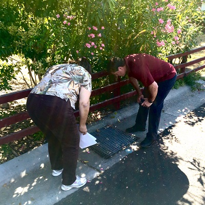
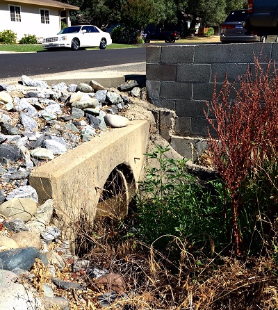
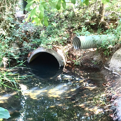
On June 28th, employees from the Placer County Flood Control and Water Conservation District came out to Pendleton Drive to inspect the storm water facilities. It was a great meeting where Placer County could directly observe that there was indeed a three foot storm water drain pipe accepting the flow of Linda Creek that is not indicated on the new FEMA flood maps.


2012 Linda Creek Flood Granite Bay
This short recording shows that Linda Creek is flowing from the street (Pendleton Drive) down my side yard into the backyard. The flow was not coming through the backyards of the homes to the east of us to any large extent as the FEMA maps represent.
