

The drought of 2014 is affecting California communities unevenly. Where Granite Bay residents may be facing a severe Stage 5 water emergency declaration by year’s end, homeowners 10 or 20 miles away may still be keeping their grass green with daily irrigation. The visual triggers in order to get people to conserve water along with regional cooperation were topics that loomed large at the July 9th San Juan Water District Drought Committee meeting.
SWRCB to ask for better Bureau communication
San Juan Water District Board Member Pam Tobin opened the meeting with a little bit of good news from the most recent State Water Resources Control Board meeting on July 1st. At the standing-room-only SWRCB meeting, Pam was able to address the Board about the concerns SJWD had over the management of Folsom reservoir by the Bureau of Reclamation. In response, SWRCB Chairperson Felicia Marcus indicated three actions they would work on –
- SWRCB will work to set up weekly meetings with the Bureau of Reclamation discuss current and future Folsom lake operations.
- SWRCB will request that Bureau of Reclamation keep SJWD comprised of changes to Folsom lake management.
- SWRCB will push to have the Bureau of Reclamation water release plan documented and then stick to it so reservoir levels can be accurately forecasted.
Granite Bay leading in conservation efforts
Drought Committee facilitator Vicky Sacksteder, Water Resource Analyst for SJWD, reported that the retail operations of SJWD had exceeded the state mandated water conservation goal of 20%. Residents of Granite Bay and parts of City of Folsom had reduced water consumption by approximately 30% over the previous year. Unfortunately, some government agencies and other districts discount the savings because other reported numbers such as the daily water use per person which is still higher than other areas of California.
Reporting measurements flawed
Water districts must report monthly on their “gallons per capita per day” consumption. This is an imperfect measure that compares current usage to a ten year average baseline for the specific district. While the SJWD can have a high daily use per person, when you switch the metric to gallons per arable acre of land, the region’s water use is not excessive. Any measurement that divides water use by population is riddled with problems. But until we develop a dual meter system that separates landscape irrigation from household consumption, communities with relatively large areas under irrigation will show a disproportionately high rate of water consumption per person.
Local water districts vary drought restrictions
The discussion of water usage measurement segued into talk of cooperation and collaboration with not only surrounding communities but the Bureau of Reclamation. A person can drive from Granite Bay to Elk Grove and pass through six or seven different water districts. All of those districts have different sources of water and varying restrictions concerning the use of that water. Granite Bay relies solely on water from Folsom lake for the most part. Elk Grove produces their water from deep commercial wells.
Consumers get mixed drought messages
While all the districts are urging water conservation, their actual drought declarations and water restrictions can varying depending on the reliability of their water. Consequently, water consumers can get a mixed messages as they travel around the region. The thought will often occur, “Why do I have to conserve water when in this community across town there don’t seem to be any water restrictions?” The perception that maybe we really aren’t facing a future water shortage becomes reality based on visual cues in the different communities. Back home in Granite Bay, some residents may not be conserving as much as possible based on an impression that other communities don’t seem to be limiting their water consumption.
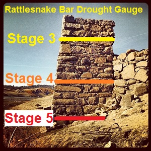
A sign from above?
What are the physical signs that the region is in a drought when we have a yearly drought called summer? Similar to a river elevation flood gauge during heavy winter storms, it would be helpful to have a visual measuring stick for drought. Since Folsom Lake is the big storage pond for the area, a visual marker on the dam with warning stages might be helpful to bring greater awareness of drought conditions. Low lake and river levels also impact the regions ground water supplies. No water in the regions creeks, streams and rivers means less water available to percolate into the ground to be pumped out later. Typically, when the Rattlesnake Bar bridge abutment was visible, everyone knew that lake was low. Can we turn that low water marker into a measurement of impending triggers for water conservation declarations?
Are Folsom Lake levels a fair measurement of drought?
To base any declaration of a drought stage entirely on the elevation of Folsom Lake is rather simplistic. There are too many variables from the time of year, inflow, snow pack and potential releases for environmental reasons to have hard and fast lake level drought warning level. The one agency that is in possession of all that data and makes the decisions on the releases is the Bureau of Reclamation (B of R), the manager of Folsom Lake. As Board member Bob Walters mentioned, the B of R has upper elevations limits for releasing water in time of high water flow, but they’ve never established low water levels that trigger a reduction in releases.
Bureau of Reclamation holds all the data
Noticeably absent for the B of R website on the statistics about Folsom Lake are any forecasts about where the elevation will be in four weeks or two months from now. For an agency full of engineers trained in modeling and forecasting events, estimating future Folsom elevation levels should be a walk in the park. The B of R knows the snow pack, inflows from the north and south forks of the American River, the water releases for power generation, environmental and downstream users, along with total evaporation of the lake each day and how much the water agencies divert from the lake. The B of R also coordinates with other Central Valley Project reservoirs such as Shasta and Trinity plus Lake Oroville in the State Water Project on releases into the Sacramento River. All of those dams and agencies work together to forecast releases to repel salinity in the delta or keep the water temperature as low as possible for migrating fish.
Forecasting Folsom Lake level
With all this information combined with the simple fact that Folsom Lake is the sole source of water for thousands of residents and business owners, B of R could easily develop a model for forecasting reservoir storage throughout the summer and autumnal months. Actually, anyone who can use a spreadsheet and create charts to forecast Folsom lake based on historical data. Even I did it. My forecast shows that Folsom lake will reach low point achieved on February 5th of 2014 by the end of August 2014. That is based on 2013 B of R Folsom Lake water release and diversion data applied to 2014.

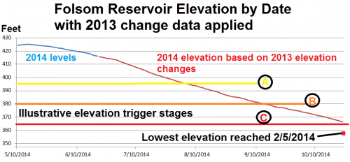
Folsom Lake elevations could trigger mandatory conservation.
If they can forecast the path of a hurricane…
Is my forecast wrong? Yes. B of R is releasing less water than they did in 2013. But even a rudimentary forecast from the B of R to the SJWD would help them and consumers who rely on Folsom Lake water determine the level of their water conservation efforts. Why wait until Folsom hits critically low water levels before declaring a water conservation drought stage? With proper notification from the B of R, SJWD and residents can start planning and implementing water conservation measures in advance of a forecasted low water level. If the government can forecast a hurricane before it slams into the U.S., why can’t they forecast an almost equally devastating event such as a water crisis because Folsom Lake is dropping too quickly before precipitation may arrive?

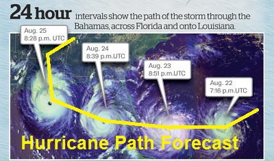
If we can forecast the path of the hurricane why can’t we estimate the level of Folsom Lake?