After the initial Gold Rush of 1849, the lower American River gold mines developed more stable and sustainable settlements along the gold fields. By 1860, there were 5,412 people in a three-county region along the north and south forks of the American River. The population was diverse with significant immigration from Europe and China. More farms and ranches were being established to support families that were now calling the area home. While some families would settle in the region, natural and economic events would dramatically change the population and economy in the 1860s.

The census pages of 1860 for the lower American River gold mines offers a snapshot of the people and economy early in California’s life. Many of the men who initially came to California in 1849 Gold Rush had left the gold mines within a couple of years. The men moved back home to the East Coast or settled in nearby towns of Auburn, Folsom, Sacramento, or Bay Area. Even though the easy placer gold had been swept out of the river bed by the original miners, there was still gold dust along the river banks and ravines to be found. The allure of gold continued to attract men and families from all over the world to the region in the late 1850s.
Analysis of Lower American River Mining Region Census 1860
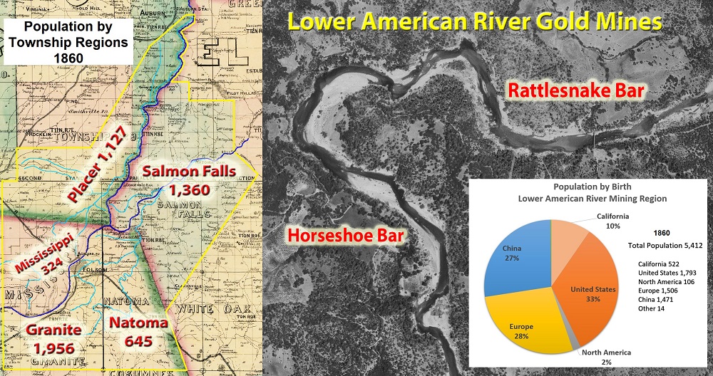
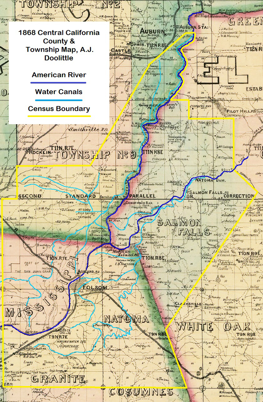
The goal of the transcription and analysis of the 1860 census was to understand the population and demographics of the lower American River gold mines. The area under study was from Sailor Bar on the American River, up the North Fork of the American River to below Auburn, and up the South Fork of American River to a few miles east of Salmon Falls. The area included 3 counties, multiple townships, and 134 pages census records.
The census collection was designed to capture that area away from the river proper that was served by water ditches for gold mining. Several water canals delivered water to miners a few miles away from American River. Those water ditches were the Bear River, North Fork, Natoma, and Clark and Fosters ditch, predecessor of the Negro Hill ditch. The diverted river water, delivered to the miners through a network of ditches, allowed gold mining to continue in areas that were devoid of any flowing water during the summer.
In selecting census pages to review, I focused on those records that listed post offices in Folsom, Rattlesnake Bar, and Salmon Falls. In general, I excluded township census pages that listed Sacramento or Auburn as the post office even if the pages were within a township I was analyzing. My assumption was residents identifying with Sacramento or Auburn post offices were sufficiently distant from the placer gold mining operations not to be intricately tied to the industry and communities.
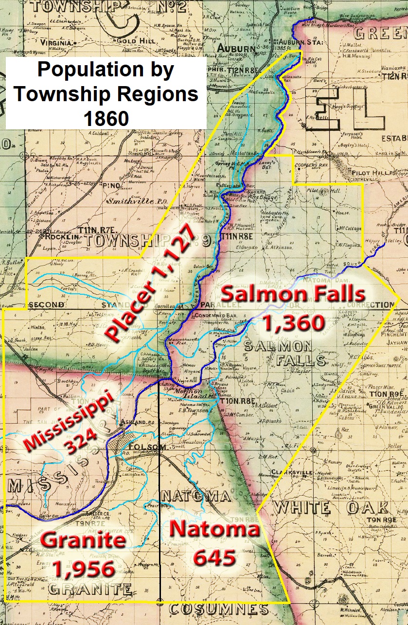
My criteria of census pages capturing gold mining regions served by the rivers or water ditches, coupled with the post office designation yielded a map I call the lower American River mining region. In Sacramento County, the townships included in the analysis were Granite, Mississippi, and Natoma. Placer County included parts of townships 1, 3, and 9. In El Dorado County, all the Salmon Falls township census tract was included in the analysis. One page of the Salmon Falls township census did identify Coloma as the post office. As the page was entirely composed of Chinese men, I left it in the group.
The boundaries for the study necessarily included areas with no gold mining. Unfortunately, it is difficult to determine where the census recorder may have been in the township when he entered the individual’s or family’s information. However, outside of the gold mining fields or urban areas such as Folsom, the population was sparse. Consequently, it was easier to capture the population of entire townships such as Salmon Falls, Granite, Natoma, and Mississippi.
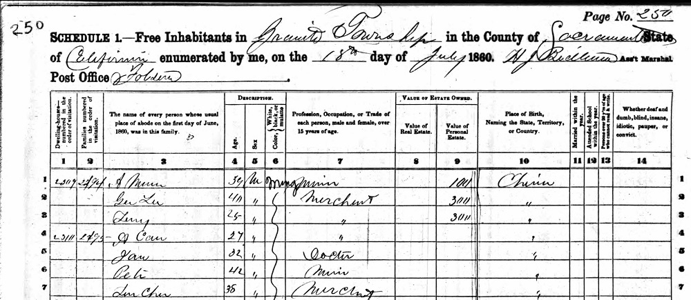
In addition to my selection criteria for the census pages to review – that introduced some level of error – the census recorders also made errors in the collection of the data. Some of the pages had sequential number errors where a dwelling or family unit number inexplicably increased. Horseshoe Bar post office was listed on one page when that location never had a post office. Names were routinely misspelled or spelled phonetically. Many Chinese men were given only one name or the first name entered as Ah when that term was more of introduction such as Mr. Smith.
The census recorders did their best given that most of the entries were made during the heat of summer in July and August. Some recorders would list the familial relationship, such as wife, to the male with the last name on the line above. Often, the familial relationship must be inferred. I have stayed away from inferences understanding that many families included sisters, brothers, aunts, uncles, cousins, and parents in the household. For example, in the David S. Beach household (Placer township 3, page 43) Mary French, age 5 is listed. David Beach became the legal guardian of Mary after her father died.
While much of data fields were straight-forward such as name, age, gender, place of birth, some of the data was left up to the discretion and interpretation of the census taker. The color or race field was up for interpretation. While some of the townships included individuals listed as Black, the Salmon Falls census tract recorder also noted Mulatto individuals. How the census recorder determined an individual was Mulatto and not Black, or some other race or color, is not understood. Uniformly, all the Chinese men and women were identified as Mongolian.
There could also be variations in the occupation listed. Some men listed their occupation as farmer. Other men, usually from Europe or China, listed their agricultural pursuit as gardener. Some men listed their job as trader, but it is unclear how trader differed from merchant. In the Salmon Falls township, the census taker did not record any merchants, but he noted 29 grocers. Was the occupation of grocer equivalent to merchant of the other census recorders?
Age Distribution Along Placer Gold Mining Region
Within the mining region there seems to have been a small population burst with 93 babies being born within the previous 12 months. The oldest person was James Lewis, age 84, who reported his occupation as miner. James Lewis was born in the Western Islands and living with Joseph Francis, also of the Western Islands, in Granite Township.
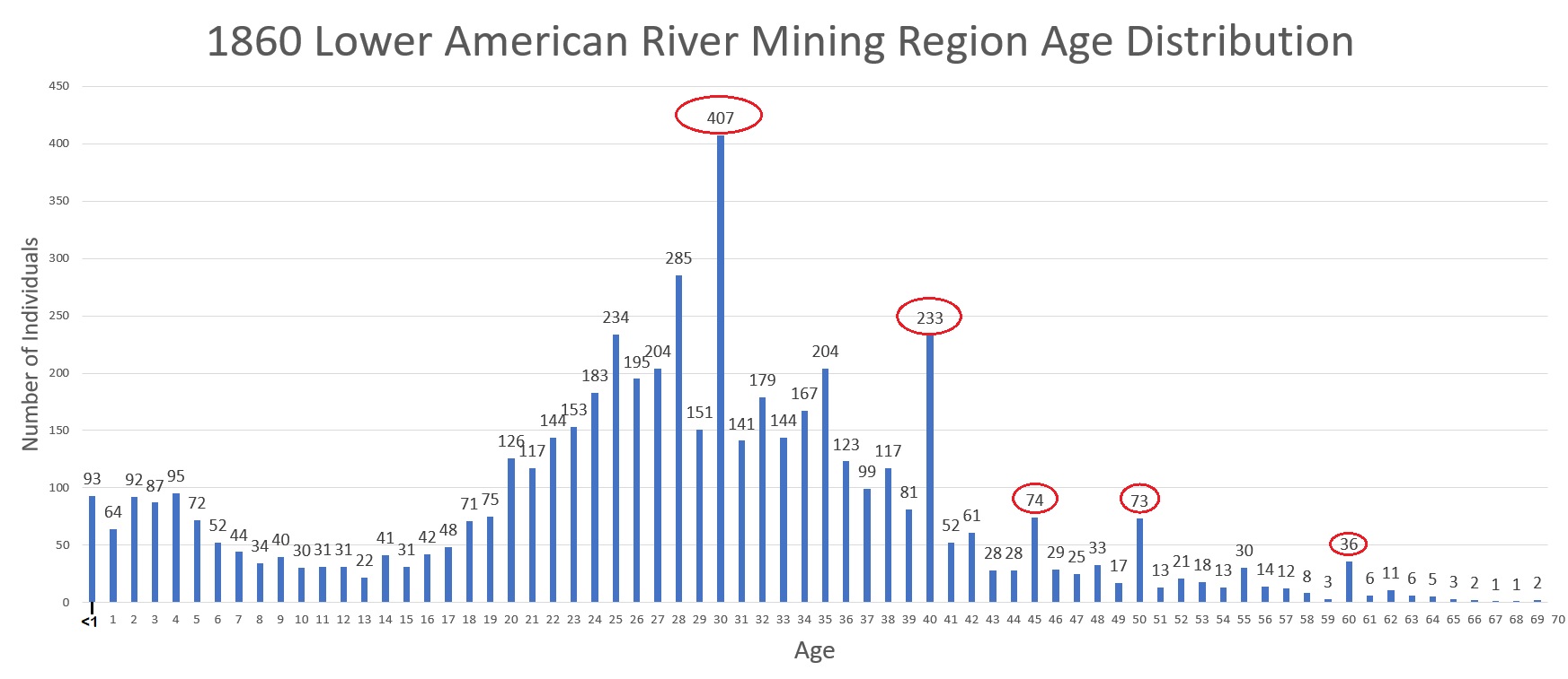
The average age of the residents was 27. It is no surprise that the number of individuals drastically diminishes after the age of 50. The region could be rugged with few roads in and out of the river canyons. Except for Folsom that was served by the Sacramento Valley Railroad, most of the locations along the river were remote and accessible only by stage coach, horse, or on foot.
There are age populations totals that deviate from the expected distribution. The number of individuals listed with an age of 30, 40, 45, and 50 are more than double than the age populations on either side of them. Two challenges that the census recorder must have faced in gathering information was the number of people who were illiterate and where English was a second language. It seems entirely plausible that the census recorders would have to guesstimate the age of the individual who may not have understood the question or did not know what year they were born in.
Continent of Birth for Residents Along the American River
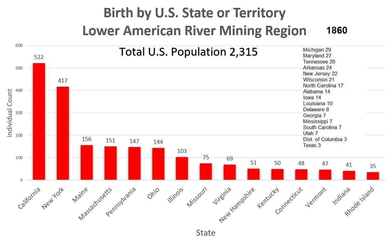
Less than half of the population of region was born in the United States. Nearly 10 percent of the U.S. residents were born in California. With a few exceptions, all the California born individuals were under the age of 12. The 33 percent of U.S. born residents includes children and young adults born in another state and migrated with the family to California.
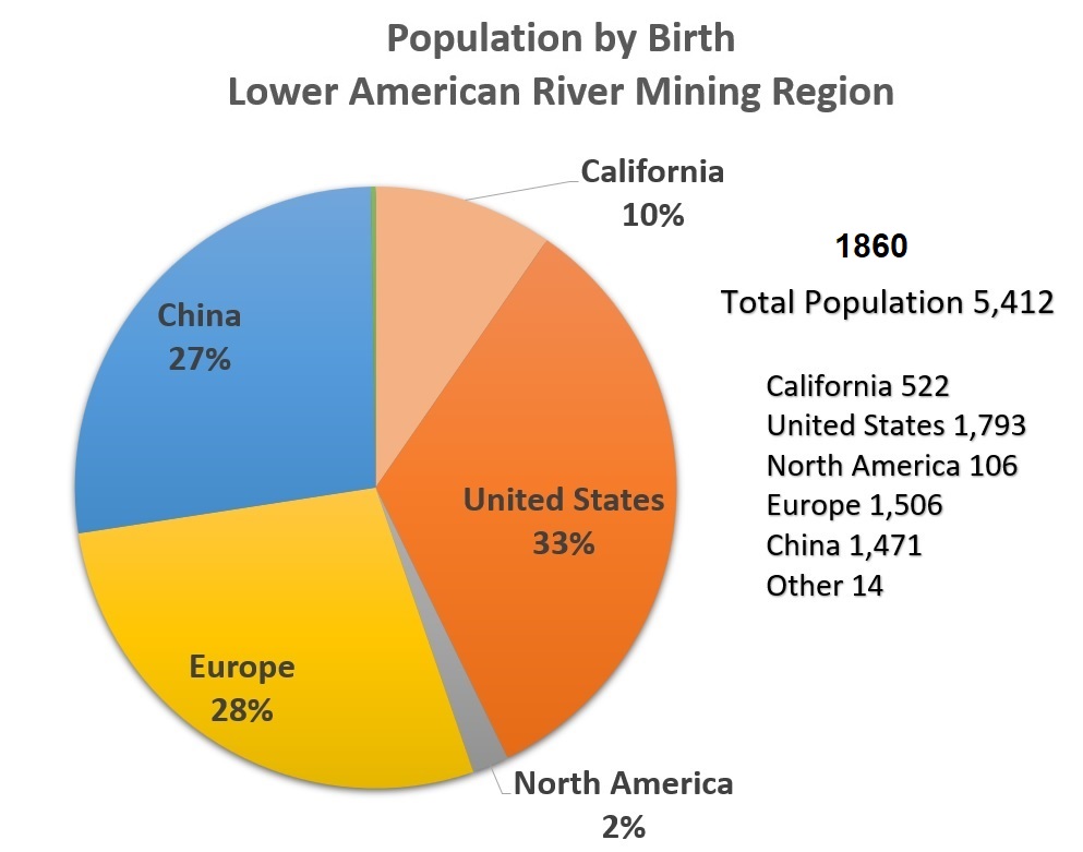
There were 1,506 individuals, 28 percent, born in Europe. However, that does not mean all those individuals migrated to the California for the gold in 1849. There were family units where one or both parents were born in a European country. By tracking the birth of their children, it is apparent that some of the European immigrants resided in other states before traveling to California.
For example, David and Elizabeth Thumuss, ages 35 and 32, were both born in England. Their first two children Leves 11 and David 8, were both born in England. The third child, George age 6, was born in Missouri. The Thumuss’ next two children, Margaret 4 and William 2, were both born in California. Working from the Missouri birth, the Thumuss’ came to the U.S. between 1853 and 1854. They then travelled to California in 1855 or 1856 and settled in Natoma Township (page 271, dwelling 2540, family 2425) and gave birth to Margaret.
Individuals born outside of the U.S. in North America comprised only 2% of the population. Countries represented by North American residents include Canada, Mexico, Cuba, West Indies, and the Sandwich Islands. There were a few migrants from Chili in South America. Australia contributed 9 individuals and Africa 1.
Individuals born in China, 1,471, represented 27 percent of the population of the lower American River mining region in 1860. Only one entry on the census pages indicated that the Chinese men were from the province of Canton in China.
European by Birth Residing in California in 1860
Numerous men and women were born in European countries and found themselves in the lower American mining region in 1860. Of the 1,506 people born in Europe, Irish birth represented 38 percent of the population or 568 people. Next was England at 17 percent and then Germany at 13 percent. Because of the fractured nature of some of the European countries, individuals reported their birth as a specific place or region.
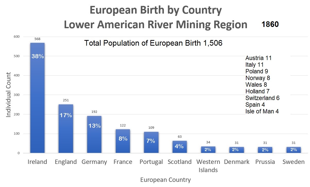
For instance, in what we know as modern Germany today, many of the individuals reported being born in Baden, Bavaria, Frankfurt, Hanover, Hesse, Holstine, Oldenburg, Saxony, or Wurttemberg. There were 10 men who listed their birth as Fayau, which is a village in France. The Western Islands, also written as the Western Isles, is commonly referred to as the Outer Hebrides of Scotland. The 34 men from that region could have been included with Scotland.
At a minimum, the European immigrants represented 10 different languages that could have been heard as you passed their mining camps. If we add Cantonese, spoken by the Chinese miners, and the various dialects of U.S. men, if one were to walk down a road in a town, it must have been a very eclectic mix of sound and voices from people all over the world.
U.S. Population by State Birth 1860
Excluding California, the state of New York was the largest contributor of residents moving to the mining region with 417 individuals. Maine was the next largest population represented with 156 residents followed by Massachusetts at 151. In addition to those 3 states, the region was dominated by northern states including Pennsylvania, 147, Ohio, 144, and Illinois, 103. Within eleven years of being populated by U.S. individuals, California born residents became the largest state represented, albeit primarily by children under the age of 12.
Gender Imbalance
It is no surprise that nearly three-quarters of the population were adult males age 16 years and older. The primary occupation was mining and the travel to California, like mining, was an arduous endeavor. There were 29 males between the ages of 11 and 15 that did list an occupation. Of these young boys, 25 were Chinese primarily working in mining.
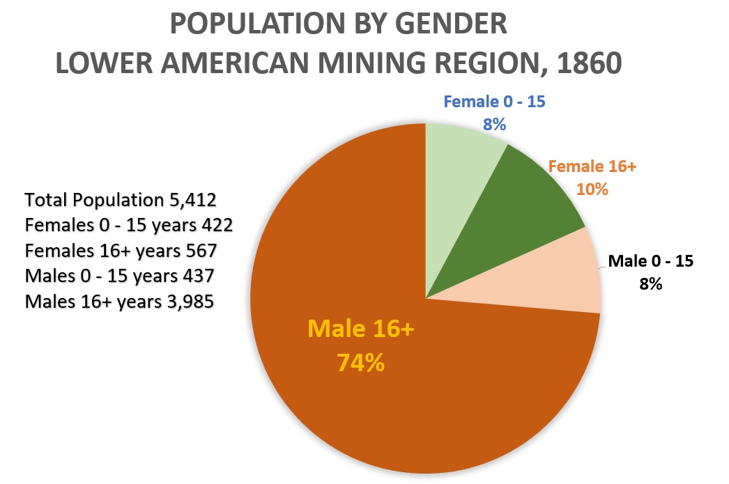
There were 567 females who were 16 years of age or older comprising 10 percent of the population. The percentage of males and females under the age 16 was nearly equal at approximately 8 percent of the population each. This would be a result of natural births in the region and children traveling with parents from other states into the area. Males under 16 years of age may be slightly inflated by incorrect assignment of age to several of the Chinese males on the part of the census recorder.
Race and Color Within The Census Pages
Census recorders only listed 4 colors or races: White, Black, Mulatto, and Mongolian. Chinese individuals were universally listed as Mongolian. The Mulatto designation only occurred in the Salmon Falls census pages. As the lower American mining region encompassed Negro Bar in Sacramento County and Negro Hill in El Dorado, I expected sizeable population of Black individuals.
While there may have been a larger Black population in earlier years, only 35 individuals were listed as black in all the census pages. Of the Black residents, 3 were women. The census recorder for Salmon Falls township listed 12 individuals as Mulatto. There 5 males and 7 females. Of this group, 6 of the individuals were children under the age of 6.
The occupations of the Black and Mulatto individuals were like other groups in the area. In addition to miner, Black individuals listed occupations such as cook, servant, day laborer, painter, peddler, butcher, poultry dealer, and saloon keeper. While most of the Black and Mulatto individuals were born in the United States, other countries of birth included Canada, Africa, England, Portugal, West Indies, and the Sandwich Islands.
There were 1,471 individuals listed as Mongolian, Chinese descent. There were 24 women within this group. There was only one Chinese child, Wan Ho, age 3, in Granite township. The remainder of the population, 3,894, was listed as White. Given that there were men from the Sandwich Islands (Hawaii), Chili, and Mexico, there had to have been other shades of skin color represented. However, it was up to the discretion of the census recorder to make the determination as to the color or race of an individual.
Occupations of Residents in 1860
Virtually the entire economy of the lower American River mining region was driven by the mining industry. Slightly less than 50 percent of all the residents were engaged in the occupation of miner. Of the 4,034 individuals listed on the census pages indicating an occupation, 66 percent or 2,655 said they were miners.
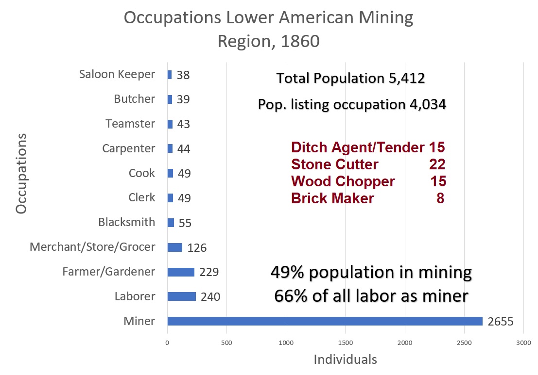
The next single largest occupation listed was Laborer at 240 individuals. Sometimes referring to themselves as Day Laborers, these men picked up work on a variety mining and construction projects. There were 44 men who listed their occupation as Carpenter using their wood working and stone mason skills on projects. The Blacksmiths were concentrated in Granite township where the Sacramento Valley Railroad and California Central Railroad had maintenance shops.
The number of men working in the agricultural sector was approximately 229. This group of individuals would expand as more vineyards and trees were planted throughout the region where there was water. Many of the support services such as teamsters, shoe and wagon makers, barbers, doctors, and saloons were concentrated in the towns of Folsom, Salmon Falls, and Rattlesnake Bar.
There were several occupations that relied on the local resources of the area. There was 22 Stone Cutters, presumably cutting granite stone for export to Sacramento and San Francisco. There were 8 Brick Makers residing in Granite township. There were 15 men who listed their job as Wood Chopper. Wood was the primary source of energy for not only homes and businesses, but also the railroad steam engines.
A key component for the placer miners was water delivered to them by the various water ditches in the area. There were 15 men who listed their occupation as Ditch Agent or Ditch Tender. The agents sold the water and collected the receipts. The tenders operated the ditch releasing water to consumers and repairing the ditch. It was repair and maintenance of the earthen ditch and wooden flumes that provided income opportunities for the Day Laborers. Frequently, Chinese men were employed to work on maintenance of the water canals. Chinese miners were also consumers of the ditch water to wash the earth for placer gold.
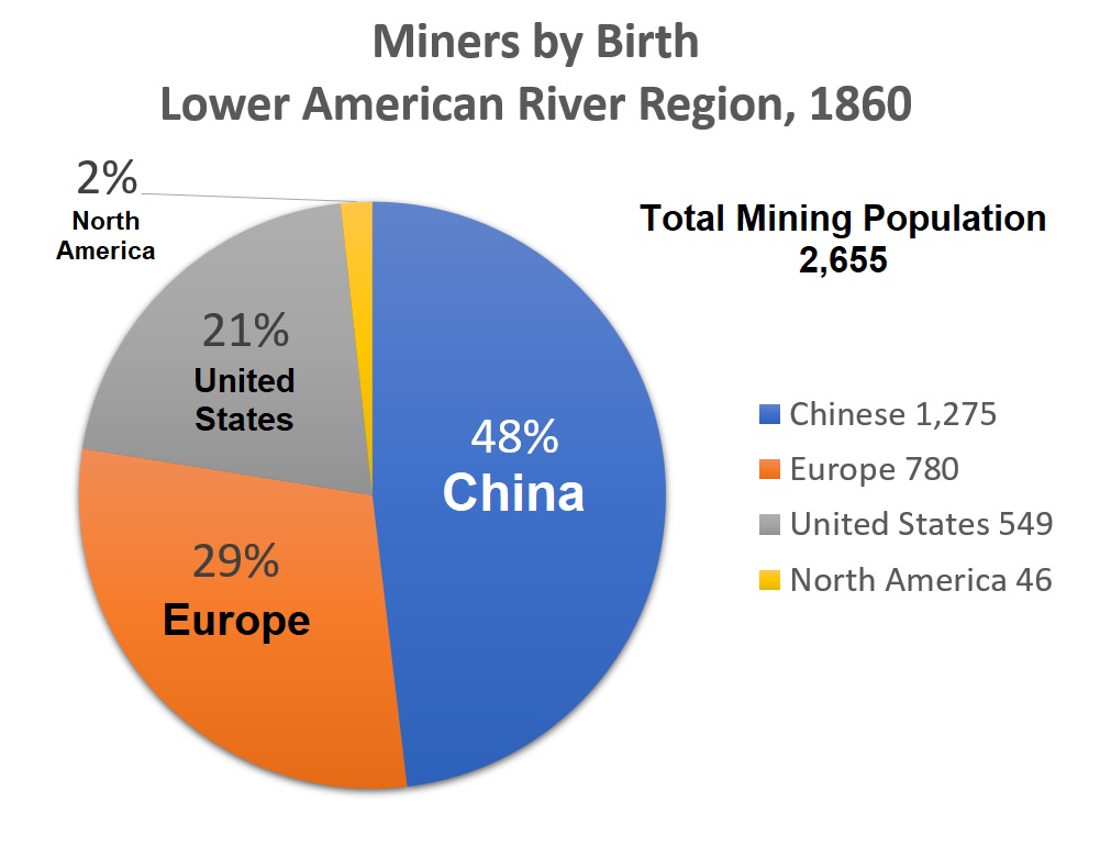
Origin of Miners
The mining industry was dominated by Chinse men. Of the 2,655 men claiming to be miners, 48 percent were from China. Men who came from a European country comprised 29 percent of the miners and 21 percent were born in the United States. Of the European miners, 304 listed a birth as Ireland, 141 from the United Kingdom, 99 from Portugal, 81 from regions within Germany, and 79 men of French birth.
The lower American River mining region seemed to tolerate the Chinese miners better than other parts of the state. There were some acts of mob violence in 1852[1] and 1858[2]. The reasons why U.S., North American, and European miners may not have engaged in as many purges of Chinese miners are diverse and would vary in the importance to individual miners. The lower American River mining region was close to Sacramento and information sources such as newspapers that provided some context to the Chinese presence. Here are a few other reasons that may have increased the tolerance of white miners for Chinese miners.
- The foreign miner’s tax raised hundreds of dollars each month for the respective counties of El Dorado, Placer, and Sacramento.
- Chinese immigrants represented a market for the sale of mining claims from U.S. and European miners who felt the claim was no longer worth the effort.
- Chinese miners were consumers of water from the North Fork, Clark and Fosters, and Natoma water canals.
- The Chinese were frequently employed by the ditch companies and others because they were willing to work for a lower wage than comparable white laborers.
- Local investors and managers of the ditch companies valued the revenue produced by the Chinese mining consumers and would speak out against atrocities committed upon their customers.[3]
Wealth Accumulation in 1860
Even with the onerous foreign miner’s tax and working low yielding placer gold mining claims, some Chinese immigrants were able to accumulate a modest amount of wealth, primarily in property. The 1860 census attempted to collect data relative to the value of real estate and property owned by the residents in the township.
There are several issues that make assigning any weight to the real estate and property values problematic. Every individual may have had their own criteria for determining the value of land and property. The dollar value given for an asset may not have been specific to where the person lived. Except for a few places in the lower American River mining region, such as Folsom, there had been no federal government map issued in 1860.
Since most of the land was owned by the federal government, until a public land survey system map had been issued for the specific township and range, the land could not be purchased from the federal government. Just because a man had bought land from another man, and registered it with the country recorder, there could be no clear title until the land, in most instances, was acquired from the federal government. Most of the Government Land Office maps of the area were not issued until after the Civil War.
A total of 322 men stated they owned real estate. The average valuation was $1,069 in real estate with a low value of $50 and a high dollar figure of $50,000. There were 10 Chinese men who listed the ownership of real estate with the highest value being $300. However, one must wonder if real estate figures may have included mining claims. Adding uncertainty to the veracity of the real estate values is that some men did not list any real estate holdings. Amos Catlin legitimately owned close to 1/5 of all the lots in the town Folsom. He listed owning no real estate or land.
Amos Catlin did list his personal estate, property, at $15,000. As a lawyer, intimately familiar with the tax laws, I must believe this estimate was fairly accurate on Catlin’s part. There was no state income tax. Personal property was taxed and the amount listed on the census may be a better gauge of wealth accumulation than real estate.
Barbers, blacksmiths, butchers, carpenters, and farmers frequently listed a value for their personal property. All those trades have specific tools they had to invest in to operate their business. There were 98 Chinese individuals who listed a value for their personal property averaging $330 per person. The highest personal property estimate for the Chinese were from 2 men who listed their occupation as merchant. Possibly it was the inventory of goods and buildings that provided the higher values for the Chinese merchants and grocers.
There were 252 Europeans listing personal property with an average of $629 per person. An outlier of wealth among the Europeans was H.B. Wadilove from England, living in Granite township, who listed his occupation as Railroad Agent and listed his personal property at $15,000. The next highest personal property value was that of David Cooper from Scotland at $4,000 who listed his occupation as merchant.
Frank Wheeler, from Canada, had the highest property estimate at $15,000 among the individuals from North America. Wheeler listed his occupation as liquor merchant. In second place was John Mc Lam from Prince Edwards Island with property worth $3,000. Mc Lam’s occupation was listed as miner. There were 14 men from North America who listed personal property averaging $1,483 per person.
There were several men born in United States who stated a personal property value of $10,000 or higher
L.B. Brooks, Massachusetts, Occupation Miner, Property $20,000
A.P. Catlin, New York, Occupation Lawyer, Property $15,000
A.T. Arrowsmith, New York, Occupation Civil Engineer, Property $14,000
C.G.W. French, Massachusetts, Occupation Lawyer, Property $10,000
J.R. Clark, Massachusetts, Occupation Ditch Agent, Property $10,000
All the men in 1860 resided in Granite township except Clark who lived in Salmon Falls township. The 1860 occupation of the men did not necessarily relate to how they acquired their wealth. Brooks, while listing his occupation as miner, spent considerable time as a contractor building the Natoma and North Fork ditches. Catlin organized both the Natoma and North Fork ditch companies and was a significant shareholder in both companies. Arrowsmith, as civil engineer, laid out the Natoma water canal and in 1860 was the president of the North Fork Ditch.
There were 326 men born in the United States that listed amount for personal property with the average being $1,050. Occupations for the men listing property values were diverse from blacksmiths to bridge toll keepers. The states from which the men came and accumulated wealth seems to be in proportion to the states represented in the mining region.
Population Decline
Political, natural, economic events sharply changed the lower American River mining region in the 1860s. The U.S. Civil War commenced in April 1861. The war slowed immigration to California and some men left the state to join the war effort. California was visited by unprecedented rain in December 1861 and into January 1862. The floods along the American River washed away dams for the ditch companies along with miles of wooden flumes. Several miners died in the flooding and the roaring waters washed away mining equipment.
The 1861-62 floods took a serious toll on the North Fork Ditch, which knocked it out of operation for most of 1862. By 1865 the Central Pacific Railroad (CPRR) was making progress on the line into and over the Sierras. The CPRR turned to abundant low-wage Chinese labor to continue building the road. The draw of working for the railroad, and not paying the foreign miner’s tax, undoubtedly drew hundreds of Chinese men away from the lower American River mining region.
With the conclusion of the Civil War in 1865, there was a rebound in the economy. However, the miners were not returning to the region in the numbers like 1860. By 1870 there were other employment opportunities on expanding railroad lines, hard rock mining, and the burgeoning hydraulic mining at higher elevations.
Chinese Population Increase 1870
A quick review of census pages for the townships in 1870 shows a decrease in population by 19 to 68 percent from 1860 numbers. The population of Chinese residents decreased in Mississippi and Salmon Falls townships. The Chinese presence increased in the townships of Granite and Natoma. Because of the addition of new post office locations in Placer County it is nearly impossible to make comparison of population changes in that part of the region.
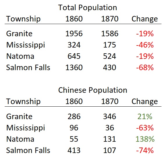
Central to the mining operation along the North Fork of the American River was the North Fork Ditch. After the floods of 1861-62, the American River Water and Mining Company who owned the water ditch never really recovered financially. There were enormous costs to rebuild the dam and the wooden flumes that had been washed away. The financial strain was increased by lower revenue from water sales to fewer miners.
There was most likely a decrease in the population in Placer County along the water ditch service area similar to Salmon Falls. Mississippi township contained North Fork Ditch water down to Ashland, Mississippi Bar, and Sailor Bar. The population in Mississippi township decreased 46 percent from 1860 to 1870. It would not be unexpected to see similar decreases in the Placer County mining regions based on Mississippi township.
The population of the mining region would eventually grow as families had children and agricultural activities increased. In terms of a gold mining-based economy, it’s possible that 1860 was the high-water mark for the lower American River mining region with over 5,000 people living and working in the region dominated by Chinese and European men mining for gold.
[1] Driving out Chinese, Sacramento Daily Union, May 5, 1852. Reports of driving Chinese miners from Mormon Bar on the North Fork of the American River.
[2] Unlawful and Barbarous Treatment of the Chinese, Sacramento Daily Union, March 6, 1858. Mob of men drive Chinese from Alder Creek mining operations and residences.
[3] Statement of the President of the Natoma Ditch Company, Sacramento Daily Union, March 10, 1858. Amos Catlin castigates the perpetrators of violence against the Chinese at Alder Creek.