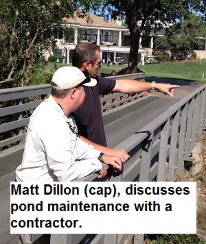
When it comes to water conservation in the face of our current 2014 drought situation, golf courses, with the numerous acres under irrigation, come under intense scrutiny. This is why I wanted to talk with my fellow San Juan Water District Drought Committee member Matt Dillon who is the Golf Course Superintendent at Granite Bay Golf Club. After learning about the golf courses three different water sources, ponds, and meticulous record keeping, I think Granite Bay Golf Club is more efficient with their irrigation water use than they even realize.
Recycled and spring water used for Granite Bay Golf Course irrigation
With a prior career in the irrigation industry I already knew that most well maintained golf courses are very efficient with their use of water. But I was surprised at how well Granite Bay Course Golf balances and manages their irrigation water which comes from three different sources to keep their golf course green. If all residential, commercial, and municipal facilities could become half as efficient as GBGC, the San Juan Water District would realize an appreciable drop in water demand. Gallery of images at end of post that can be enlarged.


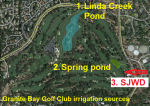
Three sources of irrigation water for Granite Bay Golf Club.
Raw Folsom Lake water used for irrigation
Built in 1994, Granite Bay Golf Club irrigates approximately 79 acres of turf on the golf course (greens, tees, fairways, rough, etc.) One of the first challenges the course developers faced was securing a reliable source of irrigation water. The local geology in the Granite Bay region does not lend itself to the construction of a commercial well that will pump the several hundred gallons per minute necessary to efficiently irrigate large turf areas. Consequently, Granite Bay Golf Course has a connection to San Juan Water District (SJWD) via the pipeline that supplies the City of Roseville’s water treatment plant on Barton Road.
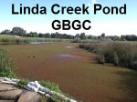
Linda Creek developed into holding pond for irrigation
It is important to note that this connection to SJWD is for raw Folsom Lake water. It is not treated potable water. (See Source number 3 on the map). This raw water supplements the surface water that the golf course captures on their property. The primary surface water collection sources for the irrigation system are Linda Creek and a spring. A 1967 USGS topo map shows a water retention basin at the site of the current GBGC Linda Creek pond. The Linda Creek pond, several acres in size, captures rain water directly from the golf course and flows from the upstream drainage area.
Residential irrigation and rain water flow into Linda Creek


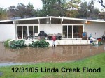
Linda Creek can produce huge amounts of surface drainage water as shown in my backyard from the floods of 2005.
The water shed for the Linda Creek pond is essentially residential storm water and excess irrigation run-off. Roughly starting at the base of Hidden Lakes on Douglas Blvd. , Linda Creek collects the all the water from the north side of Mooney Ridge on the south, Granite Bay Beach entrance on the east to the northern boundary of Hidden Lakes Estates and Douglas Blvd. As the original Linda Creek bed runs through my back yard, I can attest that a tremendous amount of water can flow into the creek. (See Linda Creek flood photo 2005.)
Recycled, spring and raw lake water management
Through enhance water conservation awareness during our current drought cycle; Linda Creek is down to a trickle this summer. Any water in the creek during the summer months is most likely from residential and commercial irrigation. Hence, GBGC is actually recycling excess upstream irrigation water that makes it way down Linda Creek into their pond. So GBGC gets brownie points for using untreated Folsom Lake water AND recycling water from upstream properties.
Is this the long forgotten Rose Springs?
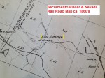
The third water source, and perhaps the most interesting, is what has been described as a spring that virtually flows year round. When Matt told me about this spring water that runs onto the golf course my history radar was immediately turned on. “Could this be the elusive Rose Springs I saw on several old maps?”, I thought. On a Central Pacific Rail Road map dated 1864 and a Sacramento, Placer and Nevada Rail Road map drawn in the 1860’s, both show a Rose Springs in Section 11 of Township 10 North and Range 7 East. (See: Sacramento, Placer & Nevada Rail Road History through Granite Bay)
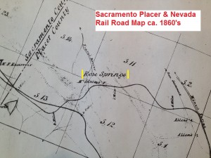
Sacramento, Placer & Nevada Rail Road map (ca. 1860’s) showing Rose Springs.
Rose Springs mining community
While it is hard to verify, I have read that Rose Springs was a small community that served gold miners working the north fork of the American River about two miles east. It’s difficult to determine if there was an actual spring or if it was in reference to an intermittently flowing Linda Creek; alternately known as Fox’s Ravine or Tracy’s Ravine on some maps. The old maps show that Rose Springs, either the community or the actual spring, was at least one mile north east from the current site of water flowing onto GBGC property. (See: Folsom to Roseville: California Central Rail Road History)
Old maps aren’t always accurate
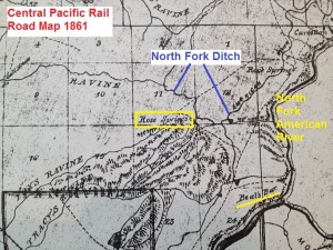
Central Pacific Rail Road map, 1861, showing Rose Springs near American River.
Unfortunately, natural features such as ephemeral creeks and even foothills were not necessarily marked accurately by the cartographer unless the feature had direct relevance to the subject of the map. For example, a creek will be accurately drawn if the rail road had to cross it. But a creek a mile away may or may not be included on the map unless it was substantial. Amateur historians such as me are left with conjecture in the absence of finding the actual mapped feature in the field.
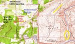
Rose Spring resurrected with construction of Folsom Dam
Regardless of whether there was an actual artesian well on the north side of what today is Folsom Lake Estates, the name Rose Springs popped up again in the 1950’s. When Folsom dam was being built in the early 1950’s, a spur of the North Fork Ditch had to be eliminated with the placement of Dyke 5 on the western side of the lake. This spur off of the North Fork Ditch, known as the Allen Ditch, traveled westerly, just north of present day Beal’s Point, and then headed northwest to deliver water to ranchers and other miners. The Allen Ditch terminated near Miner’s Ravine north of Joe Rodgers Road. (See: Historic North Fork and Rose Spring water ditch )


Reconfigured water ditch around Folsom Lakes Dyke 5 was name Rose Spring
Allen ditch delivered water up to Miner’s Ravine
In order to continue delivering water to property owners served by the Allen Ditch, the Rose Spring Ditch was built. From Hinkle Reservoir on SJWD property, the Rose Spring Ditch traveled around the foothills of today’s Folsom Lake Estates and crossed under Folsom-Auburn Road through a siphon pipe to the east side. From there it was again an open ditch until the final siphon pipe in front of Dyke 5 where it connected with the original Allen Ditch constructed sometime in the late 1850’s or early 1860’s. Possibly coinciding with the development of Folsom Lake Estates, Rose Spring ditch was abandon by the SJWD and is no longer in use.
Where is the water source for the spring?
I haven’t been able to locate any history on how this 1950’s water ditch was named Rose Springs. It might have just been a Bureau of Reclamation employee that saw the name on old maps and thought it sounded nice; an homage to history. Whether the current water flow is even related to the historic Rose Springs can’t be determined at this point. The spring or water flow onto the GBGC property may just be excessive irrigation and ground water from residential property that is at a higher elevation in Folsom Lake Estates. One would think that a spring with this volume of water flowing from it would certainly be marked on a USGS map at some point, but I haven’t found any record of such a water feature.
January 24, 2016 Update
After more research, I believe I have located both Rose Springs and Rock Springs mentioned on so many old maps. Both are within the dykes of Folsom Lake. Neither is probably capable of supplying to the amount of water that is flowing on to Granite Bay Golf Course. You can read more about my research at Historic Rose and Rock Springs at Folsom Lake.
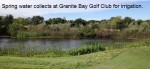
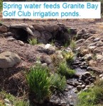
Spring water is important to Granite Bay Golf Course irrigation


Rose spring (?) water flows onto Granite Bay Golf Course as a source of irrigation water.
Granite Bay Golf Course has a general idea of how much water they receive from the spring. From an post on January 11, 2014, Upcoming Drought Challenges 2014, they write-
We currently get a flow of water coming from springs at the lower end of the City of Roseville Water Treatment plant on Barton Road amounting to approximately 170 gallons per minute per our estimation’s. This is more than enough to keep our irrigation lake full and fulfill demands for minimal dry winter irrigation needs to the course. Unfortunately for us this flow level does not persist into the summer. In an effort to capture another five to six acre feet of this “free flowing water” we are sand bagging the dam on the irrigation lake near the bridge on #1. This is the equivalent of almost two million gallons of water stored. (http://www.granitebaycourseupdate.com/2012/08/the-dog-days-of-summer-2013.html)

Real inflow and outflow water management
What the management of the three different water sources illustrates is that GBGC is more intimately involved in the balancing of their incoming water supplies than one would assume. Their irrigation system isn’t on auto-pilot where a ground water pumps just kicks-on every night without regard to any potential diminishing availability. Granite Bay Golf Course has an incentive to wisely use the Linda Creek and spring flow efficiently in order to delay opening the valve to the San Juan Water District supply. Consequently, Matt said on average they don’t start using the raw Folsom Lake water provided by the San Juan Water District until sometime in May and cease the acquisition usually in September.
Greater irrigation efficiency in the future
Even though the irrigation control system at Granite Bay Golf Club is approaching 20 years of service, it operates the irrigation system more efficiently than most of our residential controllers. Part of the efficiency has to do with the fact that half of all the sprinklers are their own zone or valve. This allows the systems to avoid over irrigating different parts of the course. GBGC is also in the process to evaluating a new irrigation control system and increasing valve-in-head control to over 80%. This GBGC blog post from last summer gives a nice overview of the different irrigation components. (http://www.granitebaycourseupdate.com/2012/08/the-dog-days-of-summer-2013.html)
Managing “hot spots” not excess irrigation

Linda Creek Pond at the Granite Bay Golf Course
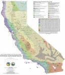
The way GBGC has scheduled their irrigation system means they are not managing excess irrigation or over watering, they are managing under-irrigated areas. They have set the irrigation controller program with the maximum daily evapo-transpiration (ET) threshold set to .22 inches per day. In other words, the irrigation system will only replace up to .22” of lost water in the soil profile to support the turf. With average ET in the Sacramento Valley easily hitting between .25” to .30” per day (see DWR California ET map at end of post), it would appear that GBGC is setting themselves up for chronic water deficits on their turf grass.
Granitic soils make irrigation a challenge
In reality, setting an ET replenishment rate below a historical average or an actual number determined by their on-site weather station indicates that Matt Dillon and his staff have a firm understanding of the water requirements of the course. The Granite Bay region typically has soils characterized by high infiltration rates and low water holding capacities because of the nature of the decomposed granite parent material. South facing low hills or berms with turf are subject to the root zones reaching a permanent wilting point moisture content level relatively quickly compared to a northerly inclined slopes or turf that might receive some afternoon shade from a large oak tree.
Days of week watering for less efficient systems
Consequently, I wasn’t surprised to see some individuals hand watering on the course the day I visited. I would rather see a member of the golf course staff hand watering a hot spot than have the whole irrigation system receive excess irrigation time just to address a few chronically moisture stressed areas. After reviewing numerous pages of GBGC accumulated data about their course and irrigation system I see no reason why they should be made to limit their irrigation to certain days of the week if we must go to a Stage 4 Drought Declaration. The specified watering days rule is a blanket measure used to force conservation. GBGC is already at conservation and efficiency levels that we humble residential sprinkler operators can only dream about.
Hard choices for Granite Bay Golf Club if drought continues
If the drought continues, meaning minimal rainfall this autumn and winter, and SJWD is pushed to Stage 4 or 5 drought declaration; I would expect GBGC will have to prioritize what areas they will irrigate. Just like any golf course, they will put a premium on the tees and greens. Residential and commercial water consumers need to determine what they can let die for lack of water and which plants are most important to keep alive. Part of the task of the SJWD drought committee is making those recommendations to help water consumers prioritize their landscape irrigation. Either way, the GBGC is setting a nice example of balancing multiple sources of surface water to be as water efficient as possible with their irrigation system.