

This web page centers on the new FEMA Linda Creek flood maps that occur within Granite Bay in Placer County.
FEMA Flood Maps on Linda Creek in Granite Bay
Background
The Federal Emergency Management Agency in cooperation with Placer County has released preliminary flood hazard maps known as Digital Flood Insurance Rate Maps (DFIRM). The estimated effective date for the DFIRM is June 2017 when some property owners will be mandated to have flood insurance. Placer County has sent letters to property owners identified in the new FEMA flood maps as being in a higher flood risk zone known as a Special Flood Hazard Area (SFHA). If the property owner has a mortgage from a federally regulated or insured lender, and the buildings on the parcel are within the SFHA, then by Federal law the lender must require the property owner to carry flood insurance when the new maps become effective.
There is a 90-day period from when the maps are published for to appeal the new or modified flood hazard information. Property owners can submit scientific or technical information if they believe the flood hazard determinations are incorrect.
August 2017 Update
Placer County Department of Public Works and Facilities has reported that FEMA has accepted the proposed changes to their 100-year flood zone maps by recognizing that Linda Creek is channeled underneath Pendleton Drive. Because of the map amendments, the final 100-year flood maps will be released in mid-September, then after a 30 day review period will become effective 6 months later.
The Placer County Division of Flood Plain Management also conducted a drainage study of the Linda Creek – Pendleton Drive situation of intermittent flooding, causes, and possible solutions. The summary of the study states,
The existing 42-inch diameter storm drain connecting Linda Creek along Pendleton Drive and Bronson Drive in Granite Bay lacks the capacity required to convey 10-yr storm runoff. As a result, properties along Pendleton Drive have experienced multiple flooding events in the past couple decades. To achieve a level of service accommodating the 10-yr storm runoff, the existing storm drain would need to be upsized to the flow equivalent of a 72-inch diameter concrete pipe. Any upsizing effort, whether it included replacement of the existing storm drain or addition of a parallel storm drain, would necessitate modifications/replacements to three existing stormwater manholes along the route. Further design constraints include inlet structure sizing, existing sanitary sewer lines crossings, manhole modifications as well as gas, cable, and other utilities.
The cost estimate is between $3 and $3.5 million, which because of a lack of funding means this fix is very unlikely to happen. There is assistance for home owners to raise their houses above the 100-year flood zone. https://www.fema.gov/media-library/assets/documents/132826
March 2017 Update
Mary Keller, Stormwater and Floodplain Program Manager, with the Placer County Department of Public Works and Facilities informed me on March 31st that FEMA has tentatively redrawn Linda Creek, along Pendleton Drive, to be shown in a stormwater pipe that runs underneath the road, and not in the backyards of the homes on the north side of Pendleton. They are also working on the topography of the area to potentially change the 100-year flood plain. But I’m not holding my breath that my house will escape the flood plain. The final map should be ready by July 2017.

Click to enlarge image
Granite Bay Linda Creek Community Response
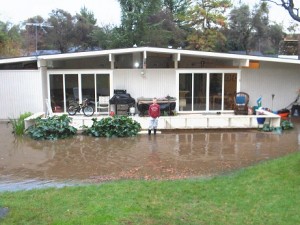
Our house at 8712 Pendleton Drive has experienced three flooding events since we purchased the property in 2003. Fortunately, the flooding from Linda Creek never entered our home. We did learn from our neighbors that the house did experience flood damage in the past. We were never told of the flooding hazard. But after the first event we did purchase flood insurance under the preferred rate since our property was not considered to be in a high risk zone – until the new FEMA flood maps are finalized.
Other property owners along Linda Creek in Granite Bay are now learning that their homes or parts of their property are within the new FEMA flood plain maps. Some homeowners, like us, will be required to purchase flood insurance. All properties touched by the new FEMA flood zones will more than likely realize a decrease in their property value because of the new FEMA maps.
Mitigation and Property Taxes
Placer County has undertaken projects to reduce flooding along creeks next to homes. Most notable was the Miners Ravine Restoration Project finished in 2002 under the Dry Creek Watershed Resource Management Plan. The restoration project cleared Miners Ravine Creek to increase water flows and added a flood water detention basin on the east side of Sierra College Blvd.
It’s possible that Placer County can undertake other mitigation measures along Linda Creek in Granite Bay to reduce the newly mapped FEMA flood hazard areas. With proper mitigation, some property owners may be relieved of having to purchase flood insurance and preserve most of the resale value of their homes. Mitigation of the flood hazard along Linda Creek in Granite Bay might include-
- Increasing the depth and width of Linda Creek as it passes through properties
- Increasing the diameter of culverts that go under roads
- Building berms to contain flood water during high precipitation events
I am not an engineer and do not know the feasibility of any of these suggestions. But it could not hurt to ask the county to investigate such measures along with potential costs.
Property Tax Valuation
The time to request a property tax re-evaluation of your assessed value is right after the annual property tax bills are sent out in early July.
Usually, a property owner must submit comparable sales within the last six months to document that their property has not been accurately valued. However, there will be no properties in the newly designated 100 year flood plain on which to compare. According to the Assessor’s office, property owners will most likely have to work with their appraisers to determine a new value for the property and home that is now in a FEMA 100 year flood plain after the maps become effective in June 2017.
Are the FEMA flood maps inaccurate?
While I’m sure every effort was made to accurately map Linda Creek in Granite Bay, people do make mistakes. Residents should carefully review the maps and compare the creek profile, elevation, and other notes to what actually exists in their neighborhood. For example, I believe the mapping of Linda Creek through my neighborhood is not correct.
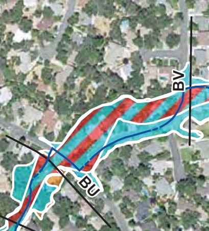
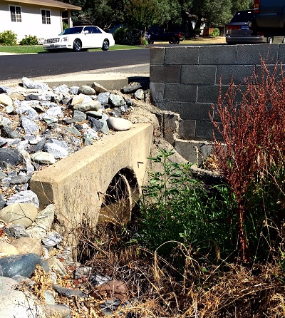
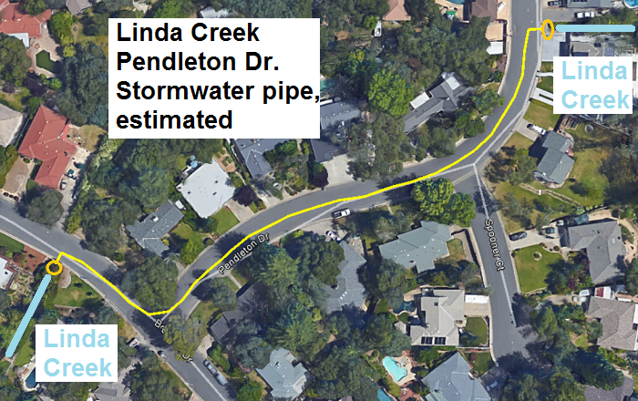
The FEMA flood map (1056 H) shows Linda Creek to the east of Pendleton Drive (green line on map) entering a culvert (red line). FEMA then shows the culvert ending at cross section BW and the creek has open flow all the way to BV. In reality, Linda Creek is diverted into an underground stormwater pipe that runs underneath Pendleton Drive and discharges back into the open creek channel at BU.
The map may be different from the actual hydraulic calculations FEMA used to determine the 100 and 500 year flood zones. Perhaps those calculations used the stormwater conveyance structure underneath Pendleton Drive, but that is never mentioned in the FEMA study. I must assume that FEMA calculated the flood zones based on Linda Creek flowing through a partial culvert of unknown size as shown on their map. If this is the case, it needs to be corrected and the proper flow and flood level calculations determined.
This underscores how important it is for community member to scrutinize the maps to look for errors and then ask for corrections. I have contacted several people at the county for assistance in verifying the conveyance structures used in the flow calculations on this section of Pendleton Drive.
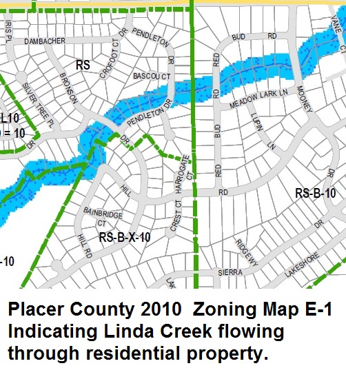
2010 Placer County Zoning Map
It is unclear where FEMA received their information about the actual above ground flow of Linda Creek. A visual inspection makes it evident that Linda Creek is diverted into the stormwater system that runs underneath Pendleton Drive. However, a Placer County zoning map published in 2010 indicates Linda Creek flowing through residential properties on Pendleton Drive. The zoning map states that there should be a 100 foot set back along this particular waterway. (In essence, they are saying that my house, and others on Pendleton Drive, are in violation of zoning laws and should not have been built.) Perhaps FEMA used this published map, available on the Placer County government website, to ink the path of Linda Creek on their new maps.
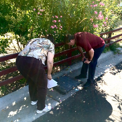
June 28th Inspection
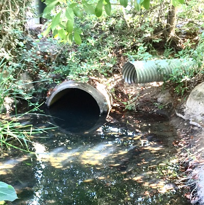
Placer County Flood Control and Water Conservation District came out on June 28th and observed the three-foot diameter storm water pipe that carries the flow of Linda Creek under Pendleton Dr. and is not indicated on FEMA maps. The entrance is at cross section BX, east of Pendleton Drive, and discharges the creek flow at cross section BU, west of Bronson Drive.
FEMA Flood Insurance Study Placer County
There are four volumes to the flood insurance study. The first volume outlines the basics of floodplain management, area studied, engineering methods, mapping methods, and references. Volumes 2, 3, and 4 contain the specific flood profiles for different sections of the creeks they studied. The list of flood profile exhibits is listed in the first volume. The Granite Bay Linda Creek Flood Profile Exhibits are in volume 3. The flood profiles are important because they identify the cross section markers shown on the map to the location and elevation on the flood profile.
[wpfilebase tag=file id=1555 /]
[wpfilebase tag=file id=1556 /]
[wpfilebase tag=file id=1557 /]
[wpfilebase tag=file id=1558 /]
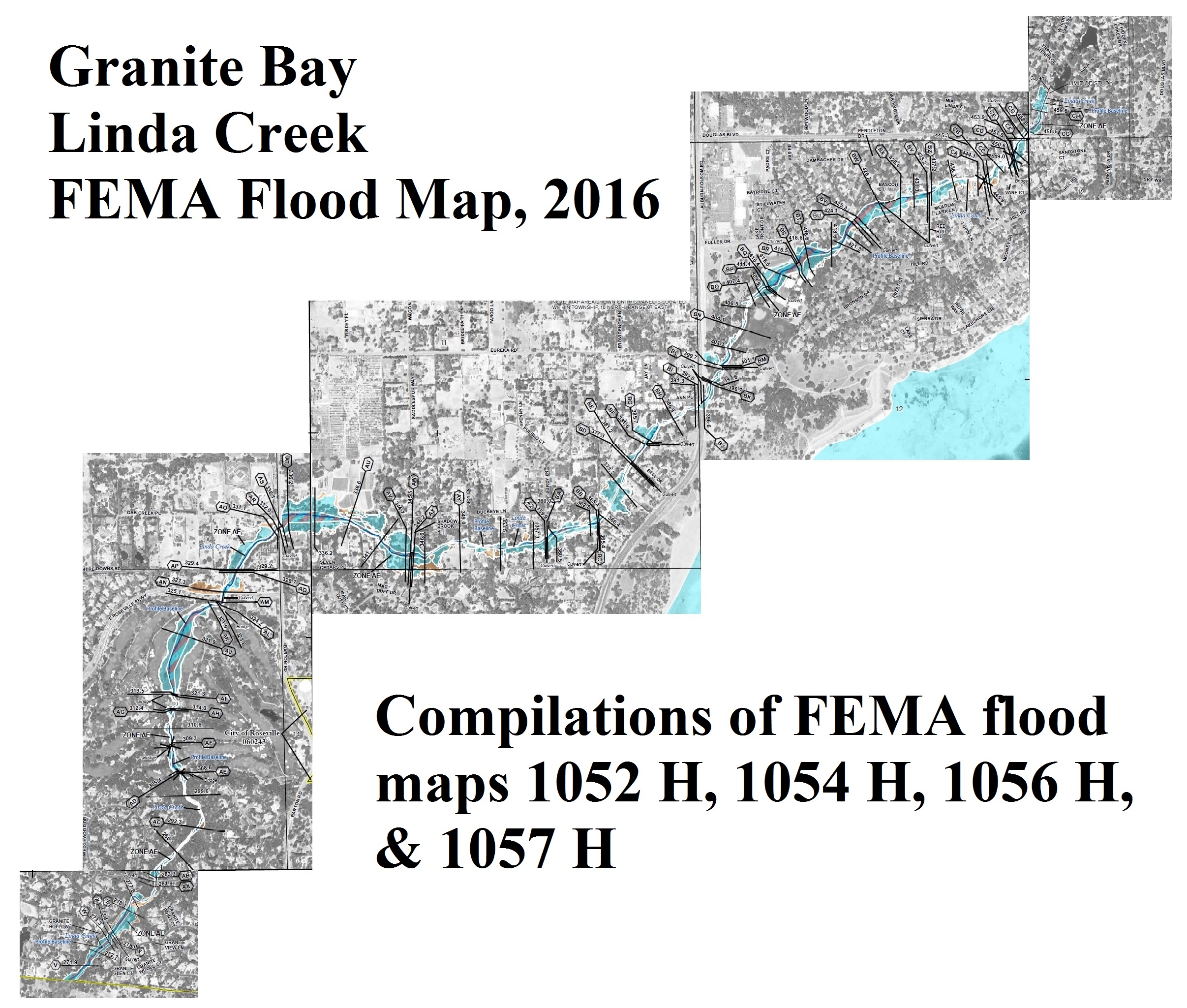
PDF version of FEMA quadrangle maps for Granite Bay Linda Creek
These are the higher resolution maps from which I made the above compilation image of Linda Creek as it passes through Granite Bay (Map numbers 06061C105x H). An even higher resolution geographical information system map online is linked below under FEMA Flood Hazard GIS Map Application. Caution, some of the maps are over 17MB file size.
[wpfilebase tag=file id=1551 /]
[wpfilebase tag=file id=1552 /]
[wpfilebase tag=file id=1553 /]
[wpfilebase tag=file id=1554 /]
Community Action
If you are impacted by the new FEMA flood maps along Linda Creek in Granite Bay and would like to confer about the possibility of getting the county to mitigate the flooding hazards along the waterway, please contact me by phone 916-521-7216 or through email on my Contact Page. Thank you for your interest, Kevin Knauss.
- Preliminary FEMA Flood Maps Online Search Tool and Download
- Placer County Flood Control Digital Flood Insurance Rate Maps
- FEMA Flood Hazard GIS Map Application
2012 Linda Creek Flood Granite Bay

This short recording shows that Linda Creek is flowing from the street (Pendleton Drive) down my side yard into the backyard. The flow was not coming through the backyards of the homes to the east of us to any large extent as the FEMA maps represent.