

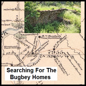
Searching for the ruins of the old B. N. Bugbey homes and vineyards at Folsom Lake.
Prominently displayed on a General Land Office, Bureau of Land Management, map from 1866 along the South Fork of the American River are noted the B.N. Bugbee old and new house. Most of this area is now under Folsom Lake. But on the trail above the lake, between the Mormon Island Dam and Browns Ravine, are the ruins of an old structure. Could this be the old Bugbey home marked on the map? And who was this B.N. Bugbey fellow to have two homes and distillery marked on map from 1866? When I compared old and newer maps, along with other historical documents, I’m fairly certain the old rock and mortar basement foundation along the Browns Ravine trail is that of once prominent citizen of B.N. Bugbey.
B. N. Bugbey Homes And Natoma Vineyard
The short story of B. N. Bugbey was that he ran a fairly successful vineyard along the South Fork of the American River in El Dorado County. He made wine, brandy, champagne, sold vine cuttings, was the Sheriff of Sacramento County and its tax collector. He also went bankrupt, lost homes and businesses to fire and lost his wife to a freak riding accident, but never seemed to give up on life. Even into his 60s, he was still running for office and active in public life.

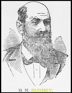
Line drawing portrait of B. N. Bugbey from 1894 when he ran for Sheriff of Sacramento County.
Benjamin N. Bugbey landed in California on June 11, 1849 after sea voyage that started in New York. He made his way up to the gold fields on the North Fork of the American River. After a time of mining he purchased a mercantile operation near Rock Springs, two miles south of Condemned Bar. At 23 years old, Bugbey continued with business interests running the Monte Christo Hotel on Coloma Road in 1852 and then a furniture business at Fifth and K Street in Sacramento in 1853.
In 1854 Bugbey started farming some land along the American River close to the town of Folsom, then known as Granite Township. In 1856 he was elected constable of Granite Township. Following on his success as a law enforcement officer he ran and was elected Sheriff of Sacramento County.
Bugbey On The South Fork American River
Sometime in the early 1860s Bugbey acquired or settled on land along the South Fork of the American River just west of Brown’s Ravine in El Dorado County. In Bugbey’s official biography he wrote in 1894 as a campaign ad to once again become the Sheriff of Sacramento County, he doesn’t mention the genesis of his Natoma Vineyards. But it was the Natoma Vineyards, his raisin, wine, champagne, and brandy production that brought him the most fame. It was also the epicenter of his greatest losses, personally and financially.

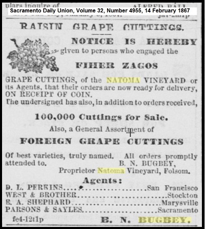
Natoma Vineyard raisin cutting advertisement for Fiher Zagos grapes owned by B. N. Bugbey, 1867, Sacramento Daily Union.
By 1864 Bugbey was exhibiting raisins from his vineyards at local and state fairs. The raisins were made from the Fiher Zagos grape and Bugbey was producing 10,000 pounds of raisins a year by 1865. At this time, the Natoma Vineyard was located on 44 acres and contained 32,000 vines of many different varietals. A description of the property states the vineyard was located in a little hollow or depression of land. A small creek ran through the middle of it and that the Natomas Water and Mining Company ditch ran to the east and south of it.
Bugbey had already begun his wine making operation in 1865. A newspaper account says that he was producing 8,000 gallons of wine and 1,000 gallons of cognac or brandy.
Sacramento Daily Union, Volume 30, Number 4586, 2 December 1865
In wine making Bugbey lets the grapes shrivel somewhat before plucking, as he thinks the wine is thereby made of better quality, although of less quantity. He has made about 8,000 gallons of wine this season, a part of which is fermented in the pulp and skins in large redwood vats containing 1,000 gallons each, and a part is made by pressing out the juice and fermenting that in the vats separate from the skin and pulp. Bugbey will probably make 1,000 gallons of cognac brandy this Fall using the second growth or late grapes exclusively for that purpose. His wine cellar and fermenting room are on the south side of the vineyard, the cellar part being built into the hill. The cellar walls and roof are composed entirely of – the slatestone found on the spot; the cellar is 18 teet wide by 54 feet long, the room being 18 feet high in the clear, the walls two feet thick, the floor laid in cement, the door of heavy iron thus making it fireproof and insuring an equal temperature at all seasons of the year. The fermenting house on top 22 feet wide by 54 feet long. In the cellar there are two casks of redwood of 1,400 gallons each, and one oak cask of 1,010 gallons, besides many smaller ones.
Some idea may be had of the climate of the vineyard from the fact that an orange tree growing in the open air bears a fine crop .of fruit which matures in February. A gigantic specimen of the prickly pear, a semi-tropical plant, is in the vineyard and bore a most plentiful crop of fruit this year. Experience having taught Bugbey the inadvisability of growing a great number of varieties of grapes for wine purposes, he intends reducing the number to twelve of the best as soon as new vines can come into bearing in their place.
Another vineyard of Bugbey is located at Duroc, about two -miles from Shingle Springs, El Dorado county. It consists of twenty acres, containing 15,500 vines, all of which, except 4,000, are of foreign varieties. Hundreds of similar vineyards maybe found ail through the Sierras, from the foothills up to 2,800 to 3,000 feet elevation.
The land immediately adjacent to the North and South Forks of the American River would not be considered a prime agricultural setting. The soils tend to be mineral in nature and full of rocks. They are relatively young soils, but they are well-drained. Early history and maps show land next to American River, now mostly under the waters of Folsom Lake, was dotted with orchards and vineyards. This is because there was water, indirectly supplied by the river. Both the North Fork and South Fork of the American River had water canals originally built to deliver water to the gold mines. The North Fork Ditch was on the North Fork. On the south side of the South Fork was the Natomas Ditch and on the north side of the river, running down to the confluence, was the Negro Hill Ditch. There were other more fertile pieces of property to grow crops in the region, but they didn’t have access to water like was provided to the Natoma Vineyards because of the water canals.
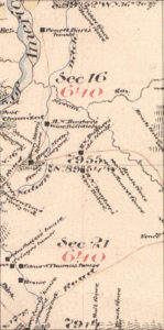
By the mid-1860s, Bugbey had built his first house at Natoma Vineyard, along with a fermenting and distillery facility, and finally, a newer home up on the hill, south of the vineyard. All these structures were captured in the 1866 General Land Office map of the area, Township 10, Range 8 East, Sections 16 and 21. In an effort to confirm the ruins along the trail above Folsom Lake were a Bugbey residence, I merged the 1866 map with the 1953 USGS Folsom quadrangle map of the area.
Click on the image to enlarge it


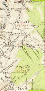

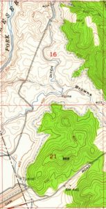
Each section of a Township and Range is a one mile square. Sections 16 and 21 line up pretty well together considering the errors inherent in older maps and my photoshop skills. The 1953 map doesn’t show any of the historical structures, but it does show the Natomas Ditch and the high water level of Folsom Lake. Clearly inaccurate on the 1866 map is the path of the Natomas Ditch. Unless the water ditch employed a flume, the ditch had to follow the contour of the landscape maintain a gently slope to keep the water flowing by gravity.
The 1866 map shows the Natomas Ditch traversing Browns Ravine and no flume is indicated. The Natomas Ditch is about 398 feet of elevation around Browns Ravine. For it to cross the ravine it would have had to drop down to 340 feet elevation and then back up to nearly 396 feet of elevation on the western side. This can be accomplished with an inverted siphon pipe like they used on New York Ravine, but there is no indications that occurred in 1866. The 1953 map shows a flume to cross the creek in Browns Ravine and that was most likely the case in 1866. However, other parts of the Natomas Ditch path do line up, especially on the southwest portion of section 21 which is now the eastern edge of the Mormon Island Dam.

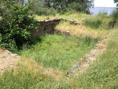
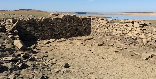
Just a few feet off of the Browns Ravine trail is the ruins of the basement wine cellar of the New Bugbey House. Folsom Lake can be seen in the background showing how the house was set up on a hill over looking the Natoma Vineyard.

The foundation for the Bugbey house wine cellar was made from local rock and mortared in placed. It was built sometime between 1863 and 1865.
If there are errors on the 1866 map, how can I be certain that the ruins of the house foundation next to the trail are that of the New Bugbey House? First, the northern portion of section 21, where the New Bugbey House is located, is above the high water line of Folsom Lake. From an old drawing of the Natoma Vineyards, the main house is clearly shown on a knoll overlooking the operation.

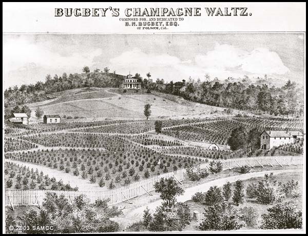
Cover of the Bugbey’s Champagne Waltz composed by Hugo Yanke, depicting the Bugby properties at the Natoma Vineyard on the South Fork of the American River. The old house in on the left, new house is on the hill center, and the distillery on the right hand side of the image. Courtesy of Sacramento History Online. http://www.sacramentohistory.org/search.php?imageid=1218
The drawing was on the cover for the composition of the Bugbey Champagne Waltz, commissioned by B.N. Bugbey and composed by Hugo L. Yanke a local pianist and organist for the Sixth Street Congregational Church. The drawing shows the old house on the left, new house in the center on the hill, and the fermentation and distillery on the right hand side. Secondly, I hiked all over the hills to the south of the old house ruins. I found and old mine and a rock wall, but absolutely no evidence of any of structures that would lead me to believe that the rock and mortared basement was not the New Bugbey House.

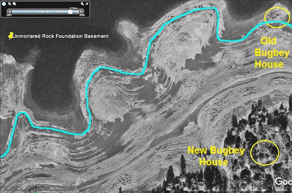
Google Earth image showing the old and new Bugbey house ruins locations along with the rock cellar location still under water in the image. The blue line is the route of the Natomas Ditch.
Finally, I compared aerial imagery from Google Earth that shows the outlines of rock foundations of both structures in the approximate locations as depicted on the 1866 map. Because both the 1866 and 1953 maps indicate the one mile square of each section, we have a relative measurement tool. My estimates from the 1866 map are that the old house and the new house were approximately .11 of a mile apart. The Google Earth measurement tool shows the distance between the two structures at .14 of a mile.

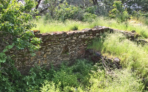
Wine cellar or distillery built into the hillside that approximates what was described as Bugbey’s fermentation and distillation structure. However, this could a building from the Mette’s vineyard that was close to Bugbey’s Natoma Vineyard operation.
I am less certain that the fermentation or distillery building depicted on the cover of the Bugbey Champagne Waltz is that of the Natoma Vineyard operations. The 1866 map shows this building further north closer to the South Fork of the American River. I took a picture of a structure built into hillside that resembles the description of a wine cellar as described in a newspaper account. Both the geo-location of my photo and the B.N. Wine Distillery shown on the 1866 map are approximately a ¼ mile from the New Bugbey House.
However, Henry Mettes also had a vineyard and house in the approximate location as the photo of the ruins of a cellar basement I took. In addition, not that location descriptions are always accurate, the old newspaper account of the Natoma Vineyard notes it was on the south side of the Bugbey vineyards. That would put the structure closer to the New Bugbey House up the hill. Unless Folsom Lake really decreases in elevation, such as during a drought, I won’t be able to re-visit that area to confirm where the Bugbey distillery was actually located.

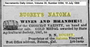
Bugbey’s Natoma Wine and Brandies Advertisement.
B.N. Bugbey was obviously a busy man running the vineyard, making spirits, and being a law enforcement officer. This may have led him to overlook a crucial task of registering his property with the General Land Office. Even though his properties were noted on the 1866 map, Bugbey never filed a title to the land either as a homestead or exercising his right to purchase the land from the federal government. Once the maps are published, people who had developed the land had three months file a patent for the land.
Normally this might not have been an issue as many squatters or settlers filed for homesteads years after the maps were published and the federal government still owned the land. But in Bugbey’s case the Natoma Mining and Water Company had a water ditch across the vineyard and section 16 was designated as being awarded to the State of California for the purposes of building public schools. Questions over title to the property and damages from the Natoma Water and Mining Company water canal led to 12 years of court battles for Bugbey.
While Bugbey was beginning his quest to acquire legal title to the Natoma Vineyards, it was hit by fire in 1867. 12,000 gallons of wine were destroyed along with some of the buildings. In August of that year Bugbey took out an advertisement offering a $500 reward for the arrest and conviction of the person who burned his storehouse and vineyard. But Bugbey wasn’t out of the farming business and in 1868 he was appointed a United States Commissioner of Agriculture based on the recommendation of John Bidwell.
On what must have been a routine trip in 1869, B.N. Bugbey and his wife were travelling to Mormon Island to catch a stage coach into Folsom, Mormon Island being only a couple miles from their home. His wife was riding a horse and he was walking beside them. Apparently, a gust of wind wrapped Mrs. Bugbey’s riding habit about the horses face. The horse bolted and Mrs. Bugbey was thrown out of her saddle but her foot was caught in the riding stirrup. This caused her to be drug across the ground and her head striking rocks along the road. She later died of her injuries.
Bugbey pressed forward after the death of his wife. He expanded his distilling operations and started advertising on a regular basis in local newspapers for his spirits. In March 1871 he demonstrated the Johnson Still for producing brandy at the Natoma Vineyard’s.
Sacramento Daily Union, Volume 41, Number 7133, 24 March 1871
The operations of the still were watched by the visitors yesterday with much interest, and the explanations of the invention received close attention. When at the close an article of brandy, 84 per cent proof, was drawn off, manufactured from an unmarketable article of wine, there was a general expression of gratification and confidence in the mode of working.
In May of 1871 Bugbey was hit again by fire. This time it was in Folsom at the Smith, Campbell & Jolly store which was next to the Folsom Telegraph office. Bugbey was leasing the basement of the building as one of his wine cellars as he was shipping his spirits throughout California and back East. It was reported the Bugbey did not have his inventory insured and the loss was estimated at $85,000.
The toll from the loss of structures, inventory, and ongoing litigation against the Natoma Water and Mining Company over title and damages to the Natoma Vineyard property must have placed a heavy financial burden on Bugbey. In 1874 it was reported that the Natoma Vineyard property was to be sold at public auction on the steps of the court house in Placerville. The notice listed 473 acres with 500 feet of river frontage. 155 acres were under cultivation as a vineyard with 100,000 of various grape vines bearing fruit.
In 1873 the Bugbey properties were valued at $22,000 as stated in a report of California Landowners. Bugbey valued the property at $80,000. Nonetheless, it was sold under foreclosure proceeding initiated by the Pacific Mutual Insurance Company and was sold for $32,000. Bugbey filed for bankruptcy in 1877 stating his liabilities were $21,025.
True to the spirit of B. N. Bugbey, even after bankruptcy, he was not out of the game of life. In 1879 he exhibits a new and improved axel for wagons known as the Wible axel. The Wible axel was self-lubricating and supposedly improved the axel life and possibly that of the driver. But here is the interesting twist. The inventor was Rev. Elias Alexander Wible, a Methodist minister who travelled all over Northern California. He obviously spent days at a time traveling between towns in wagon setting up churches and devised the new axel improvement from long rough rides.
B.N. Bugbey was the son of a Methodist Minister. Bugbey no doubt met Wible while he was ministering in Folsom. Shortly after exhibiting the Wible axel at a Mechanics fair, Rev. Wible married B.N. Bugbey to his daughter Julia, who was quite a bit younger than Mr. Bugbey. Perhaps helping Rev. Wible launch his improved axel was part of the courtship process. In 1882, Bugbey was struck again by fire at his Folsom residence. Fortunately the flames were knocked down quickly and the structured was insured.
Bugbey continued to run for public office as Sheriff and Tax Collector. He had an interest in a farm in Sutter County and gold mine he visited up in Shasta County. But his early success as a pioneering raisin farmer was obviously very close to his heart. In 1890 he wrote a scathing rebuttal to the Sacramento Union when the paper had bestowed the honor of pioneer raisin maker to a farmer in Yolo County.
In your issue of Tuesday, an article appears that robs me of my honest deserts. I don’t like to find fault with little matters, generally, but if there is one act of development in my life of which I am jealous, it is a well-established fact, fully accredited in all the Sacramento papers, and in fact all the leading papers throughout the State twenty five years ago, that B. N. Bugbey, owner and proprietor of the Natoma and the Duroc Vineyards, was the first producer of raisins for the market in America. Booth & Co will inform you that they purchased for their trade, from me twenty-five years ago, one hundred boxes of raisins at one time. I wish to state that I first made raisons in the fall of 1862, while Sheriff of Sacramento County. The agricultural reports of the State will give you this information, and further, that the State Agricultural Society did award B. N. Bugbey of the Natoma Vineyard, a gold medal in 1863 for his exhibit of raisins, the most meritorious exhibit in the Fifth Department, etc., and again, another gold medal was awarded in 1865.
I was about eight years ahead of R. B. Blowers in the raisin business. In fact, I had quit raisin making before Blowers commenced. I shipped raisin-grape cuttings to all parts of the State, and wrote essays on raisin-making before others took hold of the enterprise. Now all I care about the matter is this: If there is any credit attached to an old ’49 pioneer, in being the pioneer grape-curer, or raisin-maker, it does not belong to R. B. Blowers, nor does Mr. Blowers claim anything of the kind. I am well acquainted with Mr. Blowers, and have visited his establishment at Woodland. I indorse Mr. Blowers as being a perfect gentleman and just the kind of a man to manage ‘California on Wheels.’
I wish to say in conclusion, that I am proud of being the introducer of the raison culture in the United States, and in America. I don’t like to appear in print, but I do wish you would say in your journal that Mr. Blowers was not the pioneer raisin maker of California, but that a very humble citizen of Sacramento, who landed in Sacramento in June. 1849, by the name of Bugbey, is entitled to this honor.
Bugbey eventually moved to Sacramento and was elected Tax Collector in 1898. He was a progressive for his time. In his 1894 run for Sheriff of Sacramento County he prominently displayed the “Equal Rights to All; Special Privileges to None” tagline. He also advocated that all railroad and telegraph lines be owned and managed by the government in order to prevent monopolies. He died in 1914 at the age 87 leaving behind a pioneering legacy of early grape cultivation in California and associated products of raisin, wine, champagne and brandy. A small portion of his legacy can be seen off the trail between Mormon Island Dam and Browns Ravine in the ruins of his New Bugbee house.