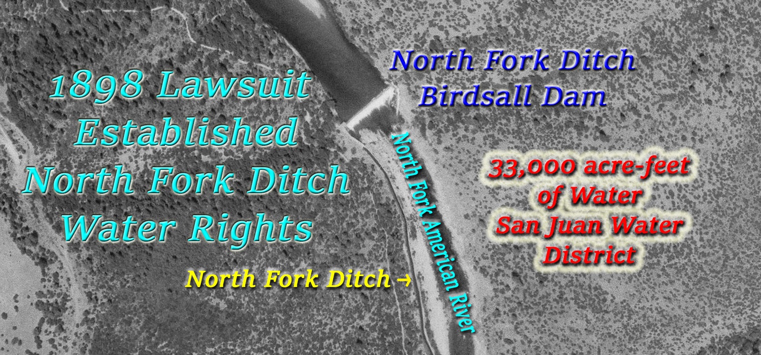
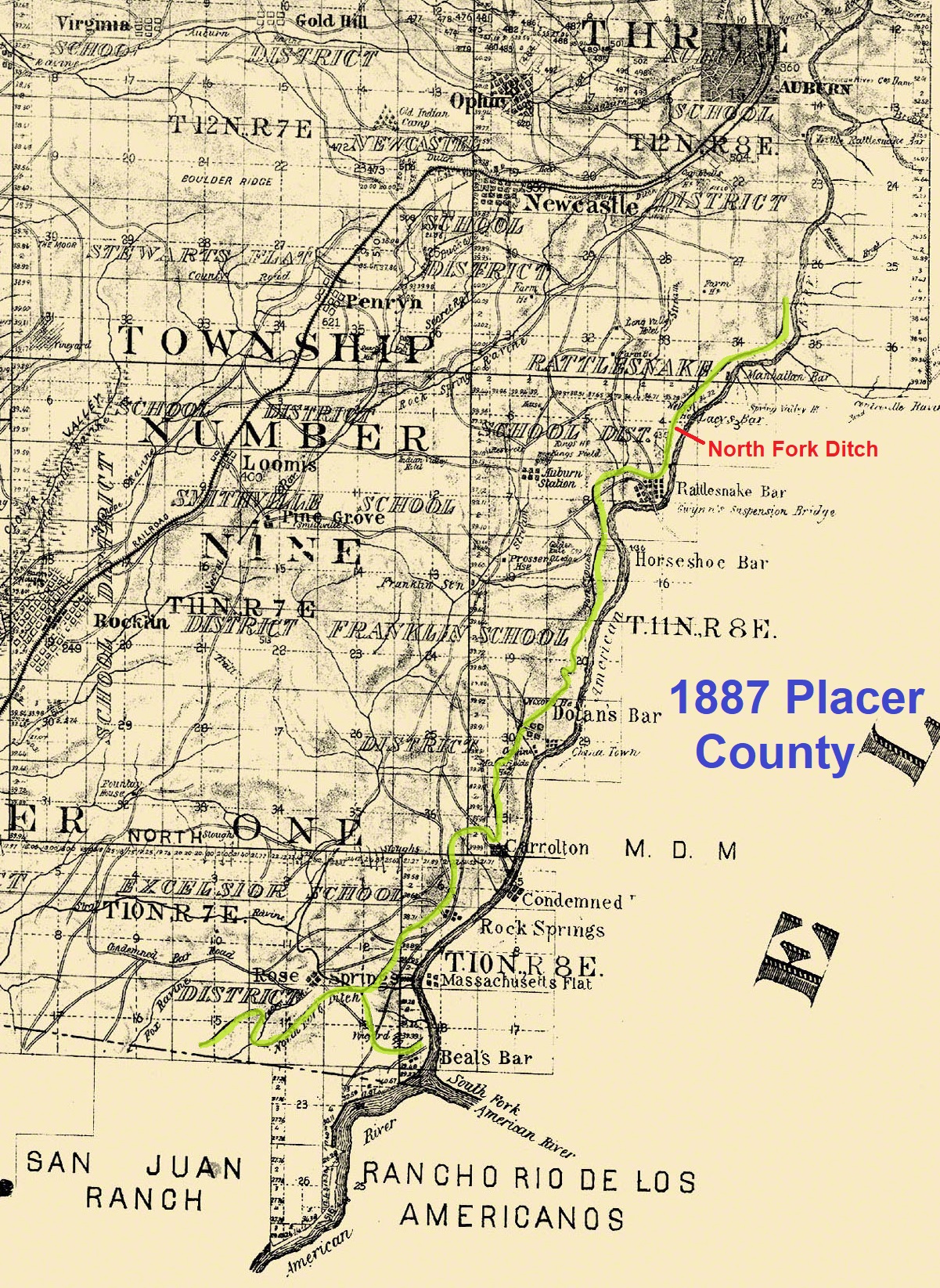
It would be 43 years after the North Fork Ditch started diverting water from the North Fork of the American River that the water appropriation was formally adjudicated. The lawsuit, and subsequent court ruling in 1898, would establish a firm appropriative right to divert a specific amount of water from the river by the North Fork Ditch. This water right would be recognized and transferred to the San Juan Water District in the 1950s by the Bureau of Reclamation.

Folsom Electricity verses North Fork Ditch Water
In terms of history, the court proceedings in the lawsuit are more interesting than the final ruling. There was a parade of witnesses that came to California in the early 1850s, mined for gold, and also worked on both the North Fork Ditch and the Natoma water ditch on the South Fork of the American River. The testimony of many of these witnesses adds to the picture of early California along the American River and the construction of the first water projects in the state. It was a fight over water and hydro-electric power that precipitated the lawsuit leading to a formal water entitlement for the North Fork Ditch.
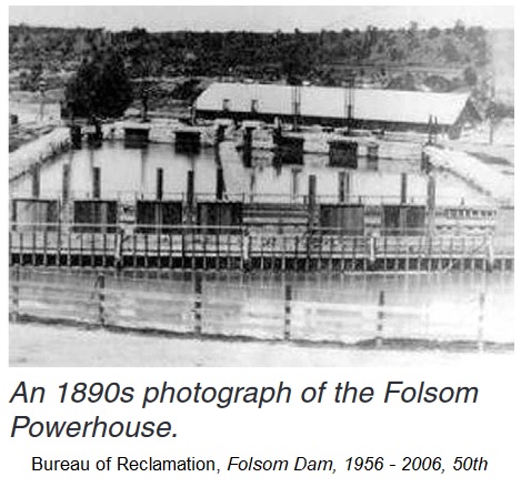
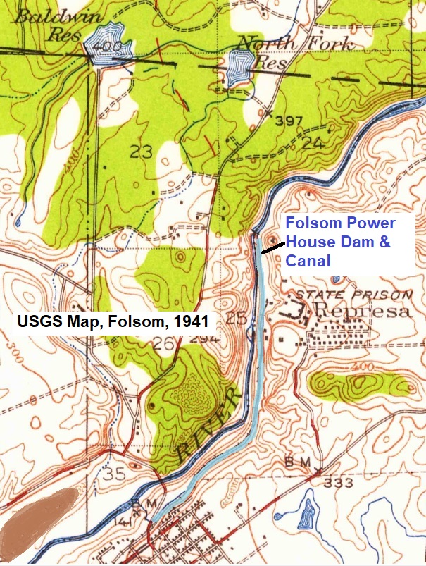
In 1895 the Folsom Powerhouse went online and started delivering electricity locally and all the way down to Sacramento. The hydro-electric power plant was driven by water diverted from the American River by a dam next to Folsom Prison. A 2.5-mile-long canal, 50 feet wide and 8 feet deep, carried 85,000 cubic feet of water per minute down to the Powerhouse turbines. At full capacity, the hydro-electric power plant could generate 4,020 horse power or 3 megawatts of power, converted to 11,000 volts.
1897 Drought
The Folsom Powerhouse was humming along supplying electricity to numerous consumers in Sacramento including the Southern Pacific Railroad shops. Then, in 1897, Northern California experienced a very dry season. American River flows plummeted. In November of 1897, it was estimated that only 175 cubic per second was flowing into the Folsom canal that sent water to the Powerhouse.[1]
Because of a lack of water to drive the turbines, several companies were told not to use any electricity. The affected companies were Southern Pacific Company, Siller Brothers (Sutter’s Mill), and the Buffalo Brewing company.[2] Since the dam was diverting all of the river flow into the Powerhouse canal, there was no water in the river between the dam and discharge at the Powerhouse.
As dry as 1897 was, both the north and south forks of the American River had water flowing down from the mountains. Unfortunately, the Natoma Dam, on the South Fork, 10 miles upstream was diverting 3,000 inches of water into their ditch system. Similarly, the North Fork Ditch, 15 miles upstream on the North Fork, was also taking 3,000 inches of water out of the river. Even with some of the water returning to the river from the water canals, there was barely enough water to operate one of the Folsom Powerhouse turbines for several weeks in November 1897.
It did not go unnoticed by the operators of the Folsom Powerhouse that in 1895, the owners of the North Fork Ditch were making improvements to their water canal from Auburn down to the Sacramento County line. The owners and operators of the Folsom Powerhouse, the Sacramento Electric, Gas & Railway Company, were convinced that the North Fork Ditch had enlarged their ditch and were exceeding historical water diversions out of the North Fork of American River.
North Fork Ditch Diverting Too Much Water
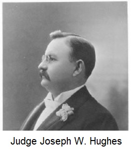
The Sacramento Electric, Gas & Railway Company (SEGR) filed a complaint in Sacramento Superior Court in 1898 stating that the enlarged North Fork Ditch, owned by C.W. Clark, H.G. Smith, and A.N. Buchanan, was diverting too much water and thereby injuring the Folsom Powerhouse operations to generate electricity. The court proceedings commenced on July 18 with Judge J.W. Hughes presiding. Representing the SEGR was attorney L.T. Hatfield. The North Fork Ditch was represented by the law firm Catlin, Shinn, & Catlin. The first Catlin was Amos and the second Catlin was Amos’ son John.
Amos Catlin Closes His Legal Career
Few lawyers in California had quite the intimate knowledge of water projects and water rights than Amos Catlin. After arriving in California in 1849 and mining for gold, Amos founded the Natoma Water Company in 1852 to build the Natoma water canal on the South Fork of the American River. In 1855, Amos organized the American River Water and Mining Company to complete what was then being called the North Fork Ditch.
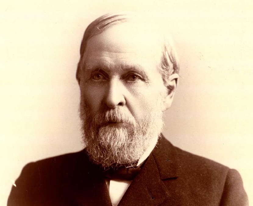
For several years Amos was the president of the North Fork Ditch and served as the superintendent of operations between 1855 and 1856. His close involvement with the development and operations of the North Fork Ditch decreased when he was elected to a California Assembly seat in 1856. Amos would attend board meetings and give his advice and counsel until the American River Water and Mining Company was sold in 1870.
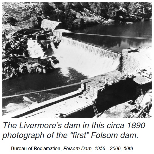
By contrast, Amos remained involved with the Natoma Water and Mining Company until 1865. Amos bought a significant portion of the Leidesdorff land grant for Natoma company operations in 1858. He began to ease out of the Natoma company in the early 1860s and sold significant shares in the company to Horatio P. Livermore. The Livermore family would eventually take control of the Natoma Water and Mining Company and pursued plans for a large dam on the American River at the Folsom Prison site in 1866.
Amos, as an attorney, would represent the Natoma company in different cases over his long career. In 1890, he represented the Folsom Water Power Company before the Sacramento County Board of Supervisors with a request to close several streets in Folsom so the company could build their big water canal from the dam to the Folsom Powerhouse.[3] Amos was at the nighttime parade in 1895 in Sacramento celebrating the delivery of electricity from the Folsom Powerhouse.
At the age of 75, after serving six years as a Superior Court Judge from 1891 to 1896, Amos Catlin was back in private practice and representing the owners of the North Fork Ditch. It was almost as if fate had decided that Amos should return to water project litigation in the remaining years of his life. While many of the men called to testify were relatively young and had only a modest understanding of Amos’ contribution to the water projects in question, there were many witnesses that Amos had worked with back in the 1850s.
North Fork Ditch Improvements or Enlargement?
Major improvements to the North Fork Ditch began in July 1895 and concluded in May 1896. As stated by A.N. Buchanan, who oversaw most of the work, the purpose of the improvements was directed at equalizing the flow from the head gates of the dam down to the new Orangevale reservoir. The work included thoroughly cleaning sediment out of the ditch, blasting rock intrusions into the ditch that impeded water flow, and adding a 400-foot tunnel to the line.[4] The improvements were designed by Russel Dunn, a civil engineer from Auburn.[5]
Unlike the Natoma canal, the North Fork Ditch did not have a large consumer base. The Natoma canal served water to farmers, ranchers, miners, Folsom Prison, the town of Folsom, and other commercial interests within its service area. Within its 25 miles of water canal, the North Fork Ditch had no major communities or industries to sell water to. That was until the Orangevale Colony and Fair Oaks Colony began to develop in the early 1890s. The problem for the North Fork Ditch was getting enough water to the end of the canal to service the colonies. In order to get sufficient water to the end of the ditch, they had to run the ditch water high in the canal. This high flow rate led to continuous failures on the canal.
A.N. Buchanan explained the necessity of the improvements. “The lower or outside walls of the ditch were weak; and when the ditch was filled with water, frequent breaks occurred. We had occasion to use the water lower down the line of the ditch than we had been using it, by reason of the fact that many of the mines that had been taking water large quantities of water shut down and by reason of the fact that the colonies at the termination of the ditch were growing and using more water. In order to strengthen the ditch, the outside walls of the ditch, and make it necessary to carry the water to such a height in the ditch, which caused these breaks, I determined to equalize the flow of the water cleaning out the projecting points.”[6]
The other major improvement to the North Fork Ditch in 1896 was an additional mile of water canal. The new ditch extended southwest, around the brow of a hill, and terminated at a reservoir. The new holding pond would become known as the Penstock Reservoir and Orangevale Reservoir because that is where the pipes were located for water delivery to Orangevale and Fair Oaks. Today, the old ditch runs through the American River Canyon subdivision and the reservoir would have been perched north of Oak Avenue next to the American River Canyon waterfall.
The attorney for SEGR, L.T. Hatfield, had several disadvantages in creating a compelling argument that the North Fork Ditch was exceeding their original appropriation of river water. First, Hatfield seemed not to be entirely familiar with the operations of ditch companies and their history. Second, he was often stymied by accurate locations along the ditch. A witness might reference the property owner, like Kelly’s place, as the place of the observation. Such a large reference made it hard to locate exactly the spot of the narrow ditch that was widened. Finally, many of Hatfield’s witnesses only gave observational testimony. The testimony lacked specificity that could be applied to the entire ditch being enlarged.
H.T. Knight Saw The North Fork Ditch in 1856
One witness for the SEGR was H.T. Knight, the Chief Engineer for the SEGR company. Knight made several reconnaissance trips to the North Fork Ditch as the improvements started in 1895. He was certain that A.N. Buchanan had increased the carrying capacity of the North Fork Ditch by 100 percent. From his visits to the North Fork Ditch, Knight examined the headgates, flumes, and earthen ditch at various spots. Knight even drew some cross section illustrations of the dimensions of the ditch.
H.T. Knight came to California in 1851 and started working on water ditches in 1857. In 1865 he went to work for the Natoma Water and Mining Company.[7] Part of Knight’s estimation of the enlargement of the North Fork Ditch was based on his viewing the ditch in 1856 when he crossed over the river on the Oregon Bar Ferry on his way to Auburn. In 1896, Knight visited the dam and viewed the headgates, based on the dimensions of the gate openings, he estimated that 2,300 cubic feet per minute were passing into the ditch.[8]
So concerned was H.T. Knight over the work of the North Fork Ditch, he kept a record from his reconnaissance trips of the locations where blasting powder was used to enlarge the ditch.
“I have a record of the number of places that they blasted. I have no record of the number of blasts, because in certain of those places, it took 40 or 50 and as many as a hundred blasts to make the break. Commencing at the lower end of the ditch now, and going up through Noonan’s ranch, they cut out 4 places from 1 to 16 feet in length. In Cook’s ranch, six places, ranging from 1 to 100 feet; in Downey’s place, 8 places, ranging from 1 to 20 feet. From Downey’s ranch to Rose Springs Ditch – that is, through the Calhoun tract – 26 places. From Rose Springs to Auburn Road, 18 places. From Auburn to Carrollton crossing, 19 places. Just above the Auburn Road was a cut, say 100 feet long, cut the full length of it through. From Carrollton Crossing to crossing of Jake Miller’s, 15. From Jake Miller’s crossing to Doton’s Bar ditch, 56 places. And they ran up as high as 100 feet in length. At the first point above Miller’s, the cut was 1,000 feet long, continuous. There is a tremendous rocky point there that was 1,000 feet long…From Jake Miller’s to Franklin House, above Doton’s Bar, 58 places that they blasted out. From Franklin House crossing to crossing opposite Whiskey Bar, 116 places. From the upper part of Whiskey Bar to Rattlesnake Hill, 28 places. From Rattlesnake Hill to the end of the granite, that is, where the sedimentary strata come in – 35 places. From the beginning of the sedimentary rock, to Dam, 61 places.”[9]
With the assistance of his son, Carl Knight, Elon Dunlap, and C.H. Spinks, they created cross-sections of the ditch before and after the enlargements.[10] However, there were only four of these cross-section diagrams showing a larger ditch on a water canal that was 25 miles in length. Knight also took some grade measurements that he learned to perform on the Natoma ditch at New York Ravine under the guidance of Augustus T. Arrowsmith.[11] From his calculations, Knight found that the grade or slope of the North Fork Ditch would vary from 2 feet to the mile to as high as 10 feet to the mile.
Marsden Manson Tested The Ditch Flow
One of the men who inspected the improved North Fork Ditch for the SEGR company was Marsden Manson. With water flowing in the ditch, Manson took measurements of the canal and flumes at different locations to calculate the water flow. Below the Birdsall Dam of the North Fork Ditch, Manson measured the canal and reported the top width was 10 feet, bottom was 8 feet, with a depth of 4 feet. Further down the canal, the dimensions had narrowed to 9 feet across the top, the bottom at 7 feet. From these dimensions he determined the water flow to be 2,562 cubic feet per minute.
At the first wooden flume he encountered, Manson measured a flume that was 6 feet x 4 feet, with a water depth of 2.8 feet. At this point, he estimated the water flow to be 2,499 cubic feet per minute. Somewhere around the Kelly Ranch, Manson determined the flow to be 2,783 cubic feet per minute, but he was unsure of the dimensions.
Just like Knight, Manson observed discharges from the North Fork Ditch. Opposite Whiskey Bar was a small flume and pipe that carried water directly to the river and across it. He estimated 120 cubic feet per minute were flowing back to the river. At the Zantgraff Mine, where a pipe line carried North Fork Ditch water over the river to the El Dorado County side, Manson approximated the flow to be 500 cubic feet per minute.[12]
After several days of testimony for the SEGR complaint against the North Fork Ditch, attorney Hatfield introduced several deeds of conveyance. First, the deed from the Natoma Water and Mining Company to the Folsom Power Company, dated December 9, 1881, for the property where the dam, canal, and Folsom Powerhouse were to be located. The second deed was from the Folsom Power Company to the Sacramento Electric Power and Light Company, dated October 27, 1893.[13] All of this was to establish the original water rights to 100,000 inches of water claimed in 1866 with the first dam on the American River next to Folsom Prison.

Opening Statements for the Defense of the North Fork Ditch
On July 21, 1898, Amos Catlin, who had handled most of the cross-examination of Hatfield’s witnesses, gave the opening statement in defense of the owners of the North Fork Ditch. Amos summarized the history of the North Fork Ditch with its mission to carry water all the way to Mississippi Bar on the American River for mining. He noted the three different dams in three different locations and how, because of raging flood waters, the ditch was often torn apart and the location slightly changed over the years.[14]
From its original construction, the North Fork Ditch had been improved, straightened, and obstructions to flow removed. However, the constant, since 1886, were the headgates installed when F. Birdsall owned the ditch. In terms of the amount of water diverted from the river, there were several places water consumers return most of the water back to the river. One specific example was the Zantgraff mine, consuming approximately 500 inches of water to drive a turbine for power, after which the water returned back to the river.
Amos propounded two questions to the Judge Hughes. First, has the North Fork Ditch used more water than it is entitled to? Secondly, does the North Fork Ditch intend to use more water. The answer to first question is no. On the second question, the North Fork Ditch does intend to use more water up to the limit of their claimed appropriation if the developing colonies of Fair Oaks and Orangevale demand it.
Augustus T. Arrowsmith Deposition
After his opening remarks, Amos then read the sworn statement of Augustus T. Arrowsmith who was living in Patterson, New Jersey. Arrowsmith came to California in 1851 to work on the proposed railroad from San Jose to San Francisco as a civil engineer doing survey work. In 1852, Arrowsmith became the civil engineer on the Natoma Water Company ditch on the South Fork of the American River. When the American River Water and Mining Company was formed in 1855, Arrowsmith became a stockholder and was elected a board member.
W.A. Eliason, who Arrowsmith worked with on the San Jose railroad survey, was also a civil engineer and was approached by several miners to lay out a ditch on the North Fork of the American River in 1852. Originally, the ditch was only to travel from Tamaroo Bar, below Auburn, down to Rattlesnake Bar. When the American River Water and Mining company was formed, with Amos Catlin as president, the ditch line was extended with the ultimate goal to serve Mississippi Bar with water.
When Amos Catlin stepped aside as president of the American River Water and Mining Company, Arrowsmith took over, in addition to his duties on the Natoma Water and Mining Company. Arrowsmith testified that all $150,000 raised from the sale of stock was used to build the North Fork Ditch. There was another $30,000 in water scrip, for a total cost to build the ditch of $180,000. Similar to the Natoma ditch, Arrowsmith posted a notice at the North Fork dam site that they planned to divert 10,000 inches of water. In reality, they were only diverting 2,000 inches after the first dam at Tamaroo Bar was complete. Arrowsmith emphasized that he did not lay out the ditch. The survey and supervision of construction were handled by W.A. Eliason.[15]
G.H. Colby and Civil Enginneer W.A. Eliason
The testimony of G.H. Colby confirmed many of the statements made by Arrowsmith. Colby lived and mined at Rattlesnake Bar from 1850 to 1856. He and some other men hired W.A. Eliason to make a survey for a ditch from Tamaroo Bar down to Rattlesnake Bar. Colby worked as part of the survey crew for Eliason as a rodman. When the American River Water and Mining Company was organized, the company paid Colby and the other men for their initial expenses with the survey. The American River Water and Mining Company then extended the survey down to Rose Springs.[16]
William Muir, testifying for the defense, was one of the few witnesses who estimated the flow of the North Fork Ditch with floats. Most of the witnesses swore they could determine the volume of flow by sight. Muir used floats and timed them as they passed under the Auburn Road bridge near Rose Springs. He was employed by the second owner of the North Fork Ditch, George Reamer, in 1872.[17]
Reamer Sells Ditch to Birdsall
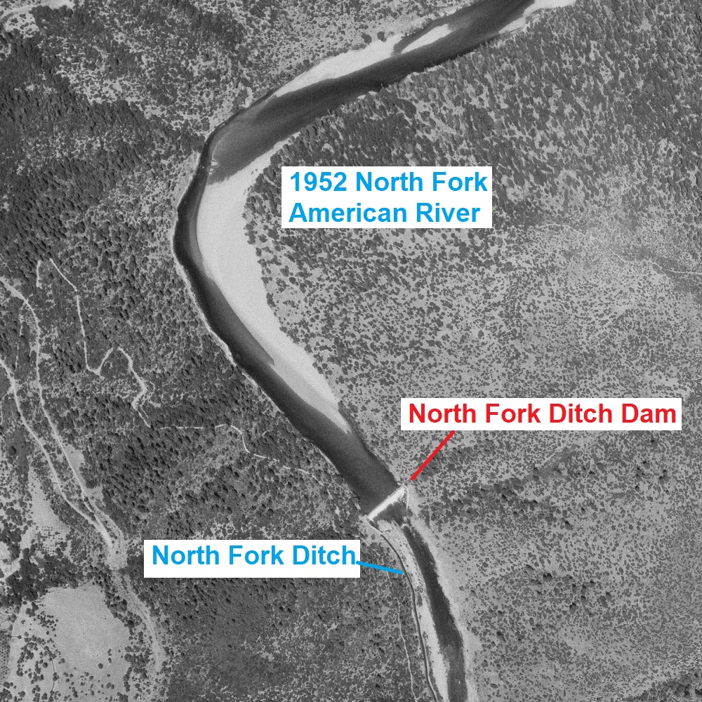
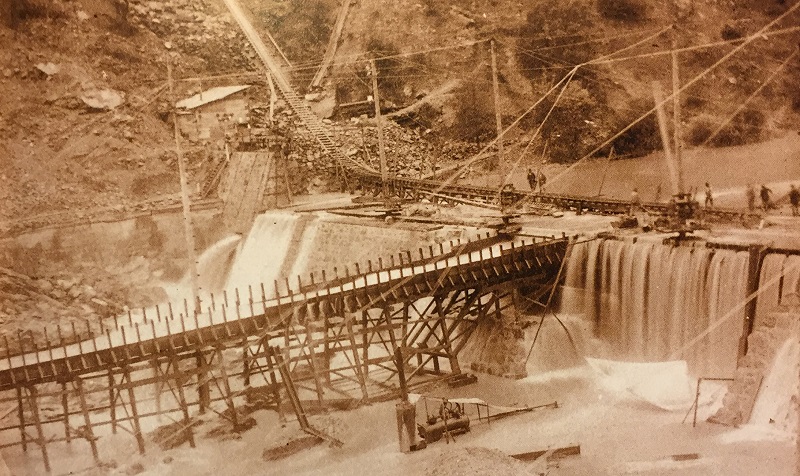
George Reamer, who bought the North Fork Ditch in 1870 for $10,000, sold it to F. Birdsall in 1875. Birdsall would sell the water canal to C.W. Clarke, L. Williams, and H.G. Smith in 1887. Birdsall built the last dam of the North Fork Ditch in 1880, approximately 800 feet below a dam that George Reamer had constructed. Birdsall testified that his new cedar dam cost $14,000. He also installed some sort of apparatus below the dam to capture placer gold that could be cleaned out at low water.[18]
Amos Catlin Testifies
Albert Shinn, the attorney working with Amos Catlin in defense of the North Fork Ditch, made an extraordinary request of Judge Hughes, he wanted to put his partner, Amos Catlin, on the witness stand because of Amos’ first-hand knowledge of the water canal. Since the opposing attorney would be given the privilege of cross-examining Amos, Hatfield did not oppose the venerable Judge Catlin from taking the stand.[19]
Amos Catlin not only organized the American River Water and Mining Company (ARWMC), he was the superintendent from 1855 to 1856 and oversaw the construction of the main ditch. He negotiated with the owners of two mining claims at Tamaroo Bar to purchase their rights so the first dam could be built. The ARWMC paid the Boston Company $600 and the Tamaroo Company $1,750 to settle their mining claim rights. Amos was confident of many of the dates because he kept a pocket diary.[20]
Even though Amos had a home at Mormon Island, he took up residence at Rattlesnake Bar, Doton’s Bar, and Carrollton at different times to be close to the construction and operation of the North Fork Ditch. After the Tamaroo Bar dam was finished, water flowed into Rattlesnake Bar on January 22, 1855. Then, on February 2, 1855, the water reached Doton’s Bar. Heavy rain in March damaged the dam and Amos had to travel to Auburn to recruit men to repair it.[21]
Amos Superintendent and President
Amos noted that in the 15 months that he was the superintendent, he and his water agents sold $128,000 worth of water, a large amount of the revenue coming from water sales at Mississippi Bar. In what was obviously a point of pride for Amos, he mentioned he sold more water on the North Fork Ditch than they did on the Natoma ditch. There seems to have been a friendly competition between Amos and Augustus Arrowsmith, who was the superintendent of the Natoma ditch at the time, over water sales.[22]
Hatfield objected to Amos’ testimony regarding water sales. Judge Hughes replied, “The motion is denied. I do not see that it is very material in the case, but it is probably a part of the history of it.” The Judge was actively listening to all of the testimony. He would ask Amos questions, correct some of the witnesses, and admonish the attorneys for asking questions that had already been answered.[23]
The Bear River and Auburn Water Company had extended their ditch into north fork mining area in 1853. Amos recalled the Bear River water was turned into Mormon Ravine and then distributed to miners at Rattlesnake Bar. The Bear River company was selling water at $0.25 an inch. Amos said he dropped the price of the North Fork Ditch water to match the Bear River price.[24]
In managing the water agents, Amos said he encouraged the water agents to give water to prospectors. It was not unusual to provide a mining prospector a week’s worth of water. The rationale being that if the miner hit pay dirt, they would continue buying water from the ditch.[25]
How Ditch Water Was Sold
Even though the miners paid for the water on a daily basis, it was assumed that the mining day was 10 hours long, after which the water was shut down. If a miner continued using water during the night, it was understood they were trying to steal extra water.[26] During his tenure as superintendent, Amos estimated the North Fork Ditch was carrying 2200 to 2300 inches of water as measured under 6 inches of head pressure.[27]
The water flowing through the night ultimately went to the Big Reservoir, as Amos called it. The reservoir was at the end of the line and was created by putting a dam across a small ravine west of the main ditch line. Amos felt the Big Reservoir covered 15 to 20 acres and received approximately 1200 inches during the night.[28]
The Judge gave Amos a wide latitude to expound on topics not necessarily related to the question asked. However, when Amos tried to correct the testimony of H.T. Knight, Hatfield objected and the Judge sustained the objection. As a witness, it was not Amos’ job to impeach the testimony of another witness.[29] The Judge did have to caution Amos for arguing with attorney Hatfield over Amos’ experience and practice of estimating ditch flow by visual sight.[30]
With respect to the physical dimensions of the original North Fork Ditch, Amos states the flumes were 5 feet across the top with sides 3 feet in height. The ditch from the head gates at the Tamaroo dam were 8 feet across the top, 5 feet on the bottom, and 3 feet on the sides. Below Rattlesnake Bar, the ditch top was 7 feet, bottom 4 feet, with 3 feet of depth. There were no tunnels on the original ditch.[31]
Buchanan Supervises Chinese and Blasting Rock
All of the estimates on the different iterations of the North Fork Ditch cited similar dimensions to the ditch and flumes. A.N. Buchanan gave the details of the work done to improve the water flow beginning in 1895. They first started with several crews of Chinese men cleaning out all the mud and debris in the ditch. Then another crew would come along and bulldoze the ditch at certain locations to remove intrusions of rock into the ditch.[32]
Bulldozing was the process of blasting rock into pieces to be removed. They used Giant Powder, also known as dynamite, in small sticks. The bulldozing crew would drill holes in the bottom or side of the ditch where there was a rock intrusion and ignite the charge. Sometimes, the Giant Powder was placed on the bottom of the ditch and covered with clay and ignited. The cleaning crew, sometimes using augers, would clear the debris and place it on the inside of the outer, or riverside, canal wall to strengthen it.[33]
The man who could have given the most detailed account of the ditch improvements was the civil engineer Russel L. Dunn. Unfortunately, the last anyone had heard, Dunn had moved to San Francisco and then to either Alaska or Siberia to work on a mining project.[34] The responsibility for providing accurate flow data on the North Fork Ditch after the improvements was civil engineer Stephen E. Kieffer.
Stephen E. Kieffer, Civil Engineer for Fair Oaks Colony
Kieffer lived at the Sunset Colonies at Fair Oaks and served as the colony’s engineer.[35] He had extensive experience with hydraulics and water canals having worked in Southern California on the Anaheim Union Company canal, Santa Ana Valley Irrigation, and South Riverside District and the water flow from Lake Elsinore.[36]
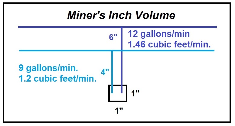
Kieffer noted that there were two different miner’s inch volumes used in California. One had a flow under 4 inches of head pressure and the other with 6 inches. All of his measurements, when he expressed the volume in miner’s inches would be under 4 inches of head pressure. The 4-inch miner’s inch produced 9 gallons per minute, while if the head pressure was 6 inches, the flow was 12 gallons per minute.[37]
Kieffer visited the North Fork Ditch on several occasions beginning on June 6, 1898. He inspected the headgates on the Birdsall dam and determined that 61.69 cubic feet per second of water was flowing into the ditch. That translated into 3701.4 cubic feet per minute or 3,084 inches. There was approximately 8 inches of water flowing over the dam.[38]
Kieffer Measures Flow Ditch Dimensions and Flow
To make accurate estimates of the water flow, Kieffer took measurements of the earthen ditch and wooden flumes with water flowing and then the water was turned out of the ditch so he could get into canal and measure the sides. At one location a short distance from the head gates, the ditch was 8.8 feet across the top, the bottom was 7.6 feet, with a water depth of 2.4 feet. He calculated 44.4 cubic feet per second water flow or 2664 cubic feet per minute.[39]
At a flume 3.25 miles from the head gates, the flume measured 6 feet across with 3.2 feet of water. Kieffer calculated 2,100 cubic feet per minute at that flume site. At another flume 6.25 miles from the head gates, Kieffer measured a flow rate 1,933.8 cubic feet per minute or 1,612 inches of water.[40]
North Fork Ditch Big Water Losses
Kieffer noted the releases or discharges from the North Fork Ditch such as at Whiskey Bar and the Zantgraff mine. However, these diversions did not account for the total diminishing volume of water flowing in the ditch. After he had collected all of his flow data at over 22 points along the ditch, Kieffer determined that the ditch lost 31 percent of its water from the head gates to the end of the line. Of this loss, 21 percent occurred in the first 3.25 miles, and the remainder over last 22 miles of the ditch.[41]
A focal point of much of the questioning of the witnesses was the volume of water directed to the Rose Springs branch, Mississippi Bar, Fair Oaks, and Orangevale colonies. All of these distributions are to the west of the main ditch. At discharges above the Rose Springs branch, there is the possibility that some of the water released for mining, power, or irrigation could return to the North Fork of the American River and ultimately be used downstream at the SEGR Powerhouse. Consequently, any water diverted to Rose Springs or to the Orangevale Reservoir could never be used at the Folsom Powerhouse.
Orangevale, Fair Oaks, Mississippi Bar Distribution
To accurately calculate how much water was directed west of the main ditch, Kieffer placed a weir in the ditch. The average over a week of measurements, 25 miles from the Birdsall dam, was a flow of 700 cubic feet per minute. While Kieffer could not get an accurate measurement of how much water was being diverted into the Rose Springs branch ditch, he knew that 175 inches was flowing to Fair Oaks, 250 to 300 inches was directed to Orangevale, and between 40 to 100 inches was flowing down to Mississippi Bar.[42]
After hearing all of the testimony and reviewing all of the cross-sectional diagrams of the North Fork Ditch, it did not take Judge Hughes long to make a ruling.
Judge Hughes Rules For Historic Flow
“It is one of the necessary elements on the plaintiff’s [SEGR] case that it prove that the defendants [North Fork Ditch owners] are not owners of water in excess of 1000 cubic feet per minute. The testimony upon this subject is this: Mr. H.T. Knight, who has known the ditch practically ever since it was constructed, has testified positively as to the size of the ditch then and since the improvement which was made in 1895 and 1896. His testimony is to some extent corroborated by the testimony of Carl L. Knight, and of Marsden Manson. Neither of the latter two witnesses claims to have made any examination of prior improvements made by the defendants in the ‘90s.
“Opposed to the testimony of these three witnesses is the testimony of a great number of witnesses; witnesses who have owned it in the earlier periods of its history – – Mr. Birdsall as early as 1875, the date of purchase, and who testified to the amount of water which was appropriated at that time; and the testimony of Messrs. Nierhoff and Boles and Colby and Johnson and the superintend, Mr. Hinkle, and a number of other witnesses as to the quantity of water carried in the ditch from the time of its construction.
“The testimony of Judge Catlin, who was one of the incorporators of the corporation, predecessor in interest to these defendants, who appropriated the water, as to the amount of water carried within the ditch. All of testimony clearly preponderates over the testimony of the plaintiff. Given to the testimony of Mr. H.T. Knight all of the weight that could under any circumstances be given to it, you cannot say, in faith of the other testimony in the case, that the testimony preponderates in favor of the plaintiff; while Mr. Knight’s statements in some particular may be slightly contradictory, yet, as I say, giving it all the weight which it is possible to give it, under the circumstances, it is not sufficient to balance the testimony of these people who have known this ditch for years.
“And without going into further details of the testimony, it does show that the defendants appropriated 3000 cubic inches of water under a 4-inch pressure when they constructed their ditch in 1854. The testimony of every witness who knew it at that time, with one or two exceptions, places it at a larger amount; and the testimony of the engineers, who have examined this ditch since then, if it is given its proper weight, confirms the view which I have expressed with reference to the other testimony.[43]
Judge Hughes did speculate upon one potential caveat in his ruling. The public works project of the Folsom Powerhouse to provide electricity to a wide swath of residences and businesses was undeniably important.
“I feel that it is my duty, however, to say that the disposition of the Court in this case would be, if it had a feeling in the case at all, to sustain a public work, which I feel is of vast importance to this city and to its people, and I feel as if this decision is going to injure a public work that is of vast importance to the people of this city; and if the testimony in this case would permit it, if a reasonable consideration and weight could be given to it to enable the Court to entertain a view which would sustain the case of the plaintiff, I believe that I could reach that conclusion – – I know I could reach that conclusion – – with a far greater degree of satisfaction than I can reach the conclusion which I have just expressed; but the testimony in this case is such that there is no weight to get around the decision which I have reached, and which be the decision in this case. Let the findings be prepared in accordance with these views.”[44]
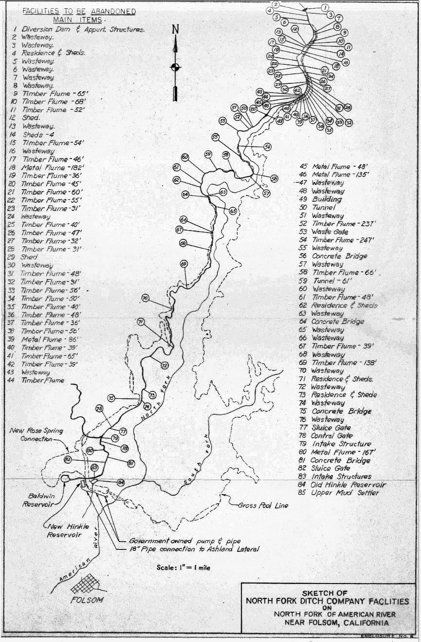
This ruling by Judge Hughes in 1898 would figure into the Army Corp or Engineer’s calculations for condemning most of the North Fork Ditch to be inundated by Folsom reservoir, supplying alternate water distribution facilities outside of Folsom Lake, and granting 33,000-acre feet of water at no charge from Folsom Dam to the water rights holder. San Juan Water District now has the pre-1914 senior water rights to this water. A water right developed during the Gold Rush persists into the 21st century and continues to provide water to Granite Bay, Folsom, Orangevale, Fair Oaks, Citrus Heights, and beyond.
Witnesses providing testimony
- Richard J. Murphy
- H.T. Knight, in-person and deposition
- Horatio P. Livermore
- Carl L. Knight
- Marsden Manson
- H.W. Hall
- C.W. Hutton
- C.H. Reuter
- Isaac Hinkle
- A.T. Arrowsmith, deposition
- G.N Colby
- William Muir
- John Kelly
- F. Birdsall
- Ralph Boles
- A.P. Catlin
- Morris A. Kelly
- Fred Nierhoff
- H.H. Johnson
- A.N. Buchanan, in-person and deposition
- Stephen E. Kieffer
End notes, unless otherwise cited, refer to the transcript of Sacramento Electric, Gas & Railway Company vs. C.W. Clarke, H.G. Smith and A.N. Buchanan, July, 1898
[1] H.T. Knight (7837)
[2] C.H. Reuter (7956)
[3] Sacramento Daily Union, Volume 79, Number 12, 7 March 1890
[4] A.N. Buchanan, (8261 – 8270)
[5] A.N. Buchanan, (8280),
[6] A.N. Buchanan, (8108, 8109)
[7] H.T. Knight (7823)
[8] H.T. Knight (7811)
[9] H.T. Knight (7976, 7977)
[10] H.T. Knight (7820)
[11] H.T. Knight (7855)
[12] Marsden Manson (7908 – 7928)
[13] L.T. Hatfield (7987)
[14] A.P. Catlin (7990 – 7996)
[15] A.T. Arrowsmith (7997 – 8010)
[16] G.H. Colby (8011 – 8022)
[17] William Muir (8023 – 8036)
[18] F. Birdsall (8041 – 8058)
[19] A.L. Shinn (8063)
[20] A.P. Catlin (8066)
[21] A.P. Catlin (8067)
[22] A.P. Catlin (8068, 8069)
[23] Judge Hughes (8069)
[24] A.P. Catlin (8070)
[25] A.P. Catlin (8071)
[26] A.P. Catlin (8074)
[27] A.P. Catlin (8073)
[28] A.P. Catlin (8073)
[29] A.P. Catlin (8074)
[30] A.P. Catlin (8079)
[31] A.P. Catlin (8071, 8072)
[32] A.N. Buchanan (8262)
[33] A.N. Buchanan (8265 – 8268)
[34] A.N. Buchanan (8280)
[35] S.E. Kieffer (8187)
[36] S.E. Kieffer (8225)
[37] S.E. Kieffer (8190)
[38] S.E. Kieffer (8193)
[39] S.E. Kieffer (8195)
[40] S.E. Kieffer (8197)
[41] S.E. Kieffer (8225)
[42] S.E. Kieffer (8213 – 8216)
[43] Judge Hughes (8256 – 8258)
[44] Judge Hughes (8258 – 8259)