

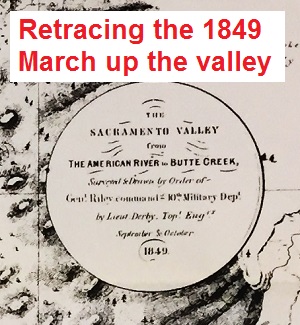
Reviewing the 1849 map of the Sacramento Valley and topographical expedition to draw the map.
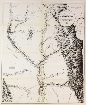
In 1849 U. S. Army Lieutenant George H. Derby performed a topographical survey of the Sacramento Valley. The “Topographical Memoir Accompanying Maps of the Sacramento Valley, &c.” was found in the Quarterly of the California Historical Society Vol. XI No. 2 publication dated June 1932. I found the small quarterly report in a book store in San Francisco and was attracted to it because of the inset map of the Sacramento Valley. The map is a reproduction of Lieutenant Derby’s topographical map he made for his report.
1932 California Historical Society Report
As the California Historical Society’s Quarterly Report points out, the cause for the reconnaissance by Derby and his party was to examine potential army sites.
During the summer of 1849 a small detachment of troops had been sent to Johnson’s Rancho, on Bear River, to establish a post for the purpose of preventing conflicts between the Indians and the increasing number of settlers at the mines of the Yuba and Feather rivers. In September, Derby was ordered to survey and mark out a reservation for this purpose and to examine other potential sites in the Sacramento Valley. Page 101
Mapping out Sacramento Valley and Camp Far West in 1849
What we have been left with is a solid historical description of the Sacramento Valley from 1849. I say solid because so many memoirs, while visually accurate, may have location and position problems within the descriptions. Derby was a trained topographical engineer and his report is far more accurate because of the measurements he took during the expedition. What I’ve tried to do is plot his troop’s route and camp sites from Sacramento City up to their destination on the Bear River using the report’s descriptions and Derby’s map. I’ve included specific text from the report that summarized their position on the trek. The overall report is very descriptive and fun to read as it paints a portrait of the Sacramento Valley in the late summer and early autumn of 1849 has the great gold rush was just beginning to get underway.
Not a perfect map
The map is not a perfect representation of the Sacramento Valley. Even if we consider the numerous changes we have made to the landscape from agricultural sloughs, drainage ditches, and the enormous destruction caused by gold mining in the rivers, there are still some minor topographical issues. The rivers (American, Feather, Sacramento, and Yuba) are not as straight as Derby depicts on his map. The other issue I see is that Derby depicts the Table Mountain region extending too far south, to the Bear River, than it really does. But given the heat, rain, camping, marching every couple of days, lack of water, and slow running chronometer, creating such a detailed map within six weeks was quite an accomplishment.
Download the excerpt of the 1849 topographical report by Lieutenant Derby from the 1932 California Historical Society Quarterly.
- [wpfilebase tag=fileurl id=821 linktext=’1849 Sacramento Valley Reconnaissance Report’ /]

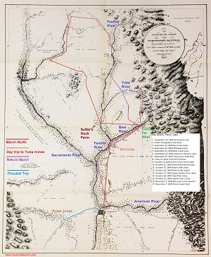
Link to full size 1849 Sacramento Valley Map with Lt. Derby’s march and campsites outlined from his report. https://insuremekevin.com/blog-post-history/1849-reconnaissance-route-of-sacramento-valley/
Chronology of Derby’s march through the Valley
Derby’s 1849 reconnaissance camp dates in the Sacramento Valley
Topographical Memoir Accompanying Maps of the Sacramento Valley, &c. – Respectfully Submitted by G.H. Derby, Lieutenant Topographical Engineers*
*Printed in Senate Executive Document No. 47, 31st Congress, 1st Session, 1850 (Report of the Secretary of War.) pp. 2 – 16, accompanied by map.
- September 22, 1849 Launching from Sacramento City
We left Sacrament City at 2 p.m. on the 22d of September, […]. Leaving Sutter’s fort about a half mile to our right, and crossing the bottom land between the Sacramento and American rivers in a direction N. 30˚ E. from the city, we arrived at the lower ford of the American River at 5 p.m., having made a distance of nearly two miles in three hours. Page 107
- Fording American River
The American river, at whose junction with the Sacramento the city is situated, is at this ford about three hundred yards in width; the banks are some thirty feet in height, but gradual and easy of ascent, which in not the case at the ford (Child’s) some eight mile above. A sand-bar, which at extreme low water is exposed, forming a small island in the middle of the river, makes out from the southern bank. At the time of our crossing the water was quite low, varying from eighteen inches to two and half feet in depth; […]. The tide rises and falls at Sacramento City, causing a variation in the depth between high and low tides of from six to fourteen inches. Page 108
- September 22, 1849 Dry Creek Camp
On crossing American, we passed through a fine grove of oaks which borders the stream through its entire extent, and, striking a more northerly direction, arrived without further accident at Dry creek, which at the time was, with the exception of a few holes, perfectly dry, […]. Its distance at our point of crossing from the ford of the American is six miles and a half. Here we camped for the night […] Page 108
Link to 1849 map of the Sacramento Valley from the American River to Butte Creek. https://insuremekevin.com/blog-post-history/1849-sacramento-valley-map/
September 23, 1849 Dry Creek camp
We made observations for latitude and longitude by meridian altitude of the sun on the 23d, and left our encampment at 5 p.m. […]. After marching fifteen miles N 10˚ W. (by the compass) we came to a small pool of stagnant water, […], and proceeding one and a half mile further on, we came to a small pond where encamped at 10 p.m. Page 108
- September 24, 1849, Nicholas camp
Leaving our encampment at 8 a.m., we soon arrived at the rancho of Nicholas Altegier [now called Nicolaus] , situated in a fertile spot at the junction of the Bear Creek and Feather River. Page 108
- September 24, 1849 Bear River camp
Leaving “Nicholas Rancho,” we continued upon the river road, passing the crossing, and encamped at a distance of ten miles from the house upon Bear creek, […]. Page 109
- September 25, 1849, Johnson’s Rancho
[…] I accompanied Captain Day on the morning of the 25th, for the purpose of assisting in the selection of the site for the proposed military post. Proceeding (by compass) in the direction N. 45˚ E., we arrived at Johnson’s rancho, a small one-story adobe building, at a distance of five miles from our encampment upon the north bank of Bear creek. Page 109
- September 26, 1849 Travel up to Yuba River
On the 26th we left Johnson’s rancho for an examination of the banks of the Yuba river and the adjoining country, striking the Yuba at “Cordua’s” or “Speek’s” bar, direction N. 25˚ W., distance seventeen miles. Here we found a company of nearly one hundred miners busily engaged in the bed of the stream, which they had partially exposed by constructing an oblique dam extending nearly across. They informed us that their operation at this point had proved extremely successful, each individual averages from two to three ounces per diem. Deer creek joins the Yuba on the south about two miles above Cordua’s bar, […] Page 110
-
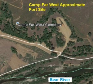
Aerial view of 1849 U.S. Army post Camp Far West on the Bear River east of Sheridan, CA.
Camp Far West Army fort location

The result of our examination was the selection of a site about half a mile above the store at Johnson’s ranch, on Bear creek. […] But the central position of this locality is probably its greatest advantage. The Truckee emigrant route, over which was passing an average of one hundred emigrants per diem, that wagon road to the Yuba mines, that to the Feather river “dry diggings”, the trail to Rose’s Rancho on the Yuba […] Page 110 (On Derby’s map he has marked the location of the Army fort as Camp Far West. This title is very difficult to read on the reproduction map.)
We returned to our encampment on the 27th of September, and made observations for latitude and longitude. The longitude worked out was probably incorrect, the chronometer have changed its rate from traveling in the wagon: latitude we made at 39˚0’6”. Page 111
September 29, 2015, Camp Far West Survey
[…]On the 29th I commenced the survey of the reserve, running the base line as nearly parallel to the direction of the stream as possible, which gave it the bearing N. 47˚ E., the perpendicular erected at each extremity having the bearing from the extremities of the base N. 43˚ W., each line one mile in length, and the base two hundred yards from and parallel to the southeast bank of the creek. This gave the reserve of one square mile, which was situated upon the northwest bank of the Bear creek, with the exception of the strip two hundred yards in width upon the other bank, reserved for the purpose of preventing individuals from squatting or settling in the immediate vicinity of the post. Page 111
Footnote 15: The post established here was named “Camp Far West”. It was occupied for a time by the detachment on the 2d Infantry, under command of Captain Hannibal Day. Log houses were built for the barracks and officers’ quarters. There was also a log fort. The soldiers, when off duty, frequently engaged in mining on Bear creek, near camp, sometimes making five or six dollars a day, thus fulfilling Derby’s prediction. The post was abandoned in May 1852, when the small remaining detachment of troops set out for the upper Sacramento to establish a post near Cottonwood Creek. Page 122
[…]We made observations for the longitude and latitude nearly every day, and found the latitude 39˚ 2’; longitude by the chronometer, repeated observations, 120˚ 45’; but I place little faith in this, for the unhappy instrument had been so jolted over the rough roads, and had altered it rates in such a very unexpected and inconsistent manner during the march, that we could place but little reliance upon its accuracy. Page 112 (Derby was correct about the chronometer because the 120˚ 45’ longitude would have put them near Forrest Hill in the Sierras. Undoubtedly the chronometer was or had been running slow due to the jostling about in the wagon.)
-
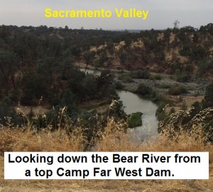
Lieutenant Derby probably saw a similar view looking down the Bear River in September 1849 when he was mapping out the valley and Camp Far West.
October 15, 1849 Sutter’s Hock Farm

On the morning of the 15th, having finished the survey and made a map of the reservation, which I left with Captain Day for the use of the post, I broke up my encampment at Bear creek and marched north, […] We arrived upon the southeast bank of the Feather River, six miles below the junction of the Yuba, at 5 p.m., at a point immediately opposite Sutter’s Hock farm”. […] I determined the latitude of Sutter’s farm 39˚ 2’ 14”, nearly identical with that of the post at Bear creek […]
We crossed at the lower seine, about one mile below the farm-house, having much trouble in getting up the bank on the west side. Page 113 (From plotting the coordinates on Google Earth, the 39˚ 2’ 14” location would be one mile south of the Sutter Hock Farm memorial plaque. If the plaque is the actual location, then the 39˚ coordinate would have been where Derby crossed the Feather River below Sutter’s Farm.)
- October 22, 1849 North Sutter Butte Camp
The heat had been intense, […], we were suffering extremely for the want of [water] […]. I therefore cause the party to halt, and sent off three men in different directions to search for water, which they found and reported at the northern extremity of the Butte, to which place we proceeded at once and encamped, […] Pages 113, 114
- October 25, 1849 Butte Creek camp
On the 25th we marched up the [Butte] creek about 15 miles, and encamped near the crossing of Lawson’s route. […] We made observations here, as we had done at our last encampment, at which we made latitude 39˚ 20’ 26”, longitude 121˚ 41’ 15”; finding latitude 39˚ 31”, longitude 121˚ 46’ 15”. Page 115
- October 26, 1849 Butte Creek camp II
We left Butte Creek on the 26th, and after travelling south of east about 15 miles over the dry and parched prairie, […], we struck “Lawson’s route.” (probably Lassen’s route after Peter Lassen). This found an extremely good road, upon which we marched some 12 miles further, passing many emigrant-wagons filled with dirty and unhappy-looking women and unwholesome children, and encamped on the bank of the Feather river, six miles above the ford. Page 116 (Derby gives no more latitude or longitude coordinates beyond the Butte Creek Camp of 10/25/49 in the report. Consequently, the remaining campsites and river crossings are approximate based on mileage and various places he marks on his map.)
-
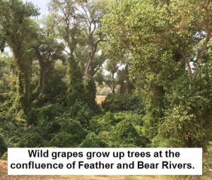
Wild grapes grow up Cotton Wood trees along the Feather and Bear River confluence, similar to what Lt. Derby might have seen in 1849.
October 27, 1849 Upper Feather River camp

On the 27th we marched six miles down the Feather river, crossing in about two feet of water. A small island in the middle of the stream renders the ford more easy, […]. We kept the river road for several miles, and then crossed the plain to the “Yuba”, nine miles further. […] We camped on the “Yuba,” in the vicinity of Rose’s rancho, a beautiful site for farming or grazing, but apparently subjected to little cultivation. Page 117
- October 28, 1849 Yuba River camp
Leaving “Rose’s rancho,” we marched across the plain to Bear creek, striking the road from Noyes’s rancho to Johnson’s at a distance of about six miles from Rose’s. We found Captain Day’s command comfortably established at camp “Far West,” upon the reserve, and preparations being made for the building. We remained here during the 29th and 30th, and made observations for the rate of the chronometer, […].
The weather had prevented our making but one lunar observation, from which I established the longitude of the Buttes, and my map is projected from that data. Page 117
- October 31, 1849 Feather River Camp
Leaving camp Far West on the 31st, we travelled down the creek to its mouth, then continued upon the branch of the Feather river until we arrived within a mile of the town of Vernon (situated at its mouth, and supposed to be the head of navigation upon the Sacramento,) where we encamped. Page 117
- November 2, 1849 Returned to Sacramento
We reached Sacramento City on the 2d of November, and encamped upon the outskirts during a tremendous storm of wind and rain, which proved to be the bona fide commencement of the rainy season. Page 118
- November 7, 1849 Putah Creek Flood
I accordingly cross the Sacramento on the 6th, at 2 p.m., and encamped on the verge of the Tule’, being unwilling to risk of remaining all night upon the plain beyond. It rained tremendously all night, and we were glad to take the road [Benicia Rd. which loosely followed Interstate 80] at daylight in the morning. We crossed the Tule’ [essentially the current Sacramento By-Pass] safely, but found the road beyond extremely heavy and covered in some places with water. […] We had arrived within half a mile of “Puta” creek, when I observed with astonishment and alarm that a strong current was setting down the road, and that the water was deepening around us with rapidity. I at once comprehended that the creek had overflowed its banks, and that we were in a dangerous position. I gave the order to the teamster to turn about immediately, but it was too late- the mules sank at once on turning from the road, the wagon was fast blocked in the yielding mud, and the water, as we afterwards found, was gaining on us at the rate of four feet an hour. […] We were compelled to abandon the wagon, with the remainder of the instruments and all our personal property, and return to Sacramento City, […] Pages 118 – 119
(Derby was able to save his chronometer, best sextant, drawing papers and instruments. The remaining topographical instruments including compasses, tripods, chains and pins, and sextant, were retrieved and sent to him the following year).
November 10, 1849 Arrival at Benicia
I arrived at Benicia on the 10th of November, from which place I had the honor to send you a detailed report of the loss of my wagon, and other circumstances connected with my expedition. Page 119
Derby’s impression on land and Native Americans
After Derby’s reconnaissance of the Sacramento Valley up to Butte Creek he saw little value in establishing a military post. He was less than kind, but probably expressed the prevailing sentiment of the day regarding the Native Americans.
A position at the north Butte, or upon Butte creek, at some point near the crossing of Lawson’s route, would be undoubtedly more pleasant in every respect, perfectly healthy, and would possess every requisite for the comfortable subsistence and shelter of the troops; but beyond the attaining of these points, I can conceive of no advantages to be derived from establishing a post in that vicinity. There would be no inhabitants to protect, and nothing to in fact to protect them from. Page 119
There are two rancherias of Indians upon the Sacramento, on upon Butte creek, three upon Feather river, and one upon Bear creek. […] All that I have seen appear equally ugly, harmless, and inoffensive; but, being perfectly barbarous, and acting, as I imagine, more from instinct than reason, they are liable to commit, at any moment, some unexpected outrage, for which neither themselves nor any one else can assign reason. Page 119
As far as I could ascertain, by inquiry, from those person most likely to be best acquainted with their character and habits, all of these Indians are to viewed with suspicion and distrust; and I found it generally conceded that those termed “Christian Indians,” who, by their intercourse with the whites, had added to their original qualification of low cunning by the a Rancheria. Should the present rapid emigration to this country continue during the ensuing year, the entire valley will undoubtedly be thickly settled with a hardy population, who, attracted by the fertile soil and beautiful scenery of the banks of the Feather river and its branches, will brave its sickly climate, preferring to reap a sure and lucrative harvest from agricultural pursuits to enduring the hardships, exposure, and sickness of the mines for a doubtful prospect of immediate wealth. Page 120
1849 speculations come to true
Many of Derby’s conclusions were correct; the Native Americans would be overwhelmed by emigrants and serious conflicts reduced to zero probability and the economy would shift from mining enterprises to that of agricultural endeavors. Within the month and a half Derby marched through the Sacramento Valley conducting his topographical survey in the autumn of 1849 he experienced the full spectrum of Northern California weather from brutal suffocating heat to bone chilling rainstorms. His observations of the Sacramento Valley in 1849 are an interesting read detailing the landscape before large scale agriculture, levees, and the massive dams built on the Sacramento, Feather, Yuba, and Bear Rivers changed the landscape.
1849 Map Markers, Places, Dates
- September 22, 1849 Sacramento City
- Child’s fording American River
- September 22, 1849 Dry Creek Camp
- September 24, 1849, Nicholas Camp
- September 24, 1849 Bear creek camp
- September 25, 1849, Johnson’s Rancho camp
- September 26, 1849 Travel up to Yuba River
- Camp Far West Army fort location
- October 15, 1849 Sutter’s Hoch Farm Camp
- October 22, 1849 North Sutter Butte Camp
- October 25, 1849 Butte Creek camp
- October 26, 1849 Butte Creek camp II
- October 27, 1849 Upper Feather River camp
- October 28, 1849 Yuba River Camp
- October 31, 1849 Feather River Camp
- November 2, 1849 Returned to Sacramento
- November 7, 1849 Putah Creek Flood