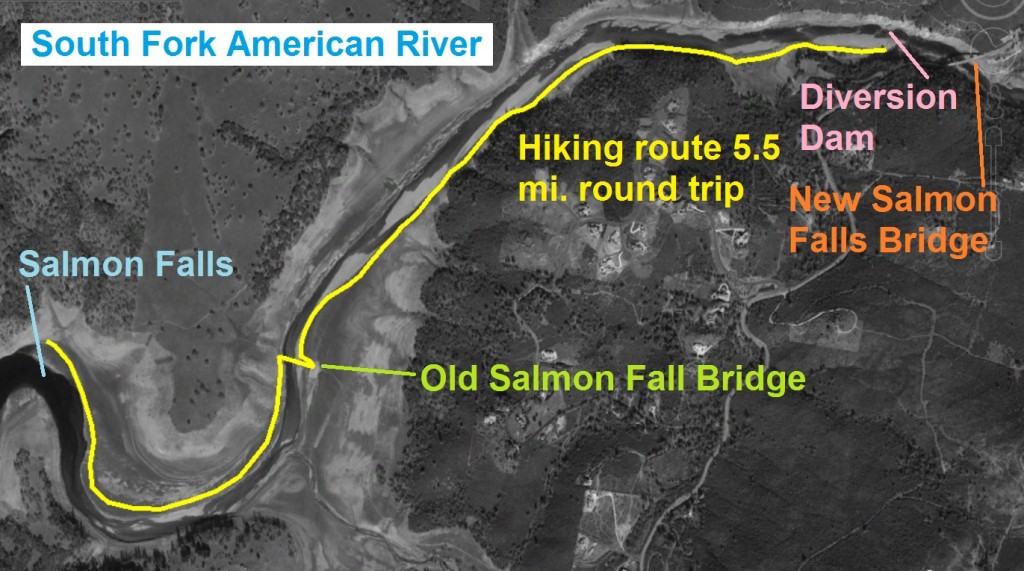
Hiking from the current Salmon Falls Bridge to the old concrete bridge usually under Folsom Lake.
A 2015 drought depleted Folsom Lake has allowed a rare opportunity to hike from the current Salmon Falls bridge over the South Fork of the American River all the way down to the old bridge which is usually covered by Folsom Lake. What makes this hike so special is that the South Fork of the American is flowing free like a river should. You can actually walk on and next to the historic Natomas Ditch and see the old dam that diverted river water into the canal that traveled all the way down to Folsom. Full picture gallery, video and maps located at end of post.
Drought allows So. Fork American River free flow
It is only during severe droughts coupled with the Bureau of Reclamation releasing an extraordinary amount of water from Folsom Lake that the South Fork of the American runs free for several miles south of the current Salmon Falls Bridge. Unless California remains in a low grade drought for years to come, this sort of low lake level and free flowing river won’t occur again for decades.
Hiking from one Salmon Falls Bridge to another
With the exception of the barren landscape next to the river where the lake usually kills all vegetation, walking along the South Fork of the American River now must be very close to what Native Americans and gold miners experienced in the 1850’s. The water is clear. The river bed is full of gravel and sand, not muck and mud. And you can look up at the towering hills that make up the river canyon. You can park at the Folsom Lake SRA parking lot west of Salmon Falls Bridge on Salmon Falls Road. If you hike down to Salmon Falls on the river it will about a six mile round trip hike.

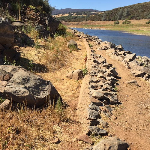
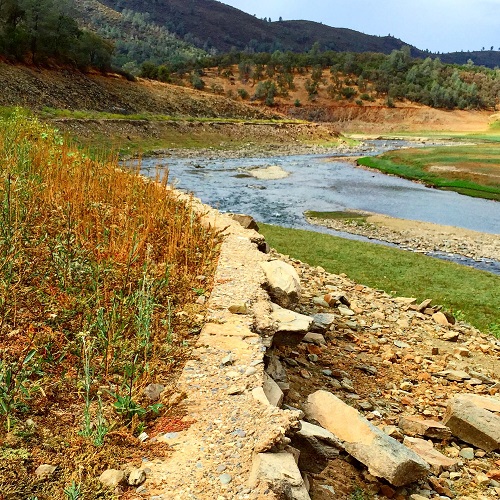
Parts of the old South Fork Ditch make a great level trail down to the old Salmon Falls Bridge.
Natomas and Negro Hill Ditches
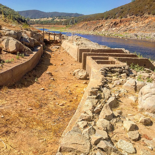
The low water level exposes the several historic structures along the river. In the early 1850’s the Natomas Water and Mining Company constructed the first dam and water canals on the South Fork of the American River. The diversion just west of the current Salmon Falls Bridge close to the Folsom SRA parking lot, diverted river water into two canals. The larger canal called the Natomas Ditch was on the south side of the river and ultimately delivered water as far east and south as Prairie City Diggins by the City of Folsom. The canal on the north side of the South Fork of the American River was known as Negro Hill Ditch on later topographical maps. It terminated at Negro Hill which was opposite the Mormon Island town site on the south side of the river.
Water canals built by hand in the 1850’s
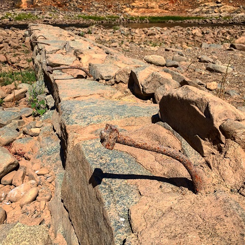
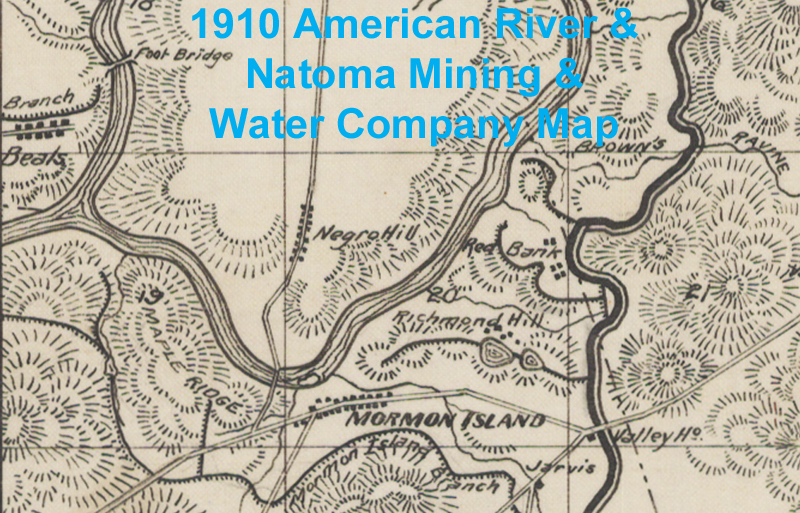
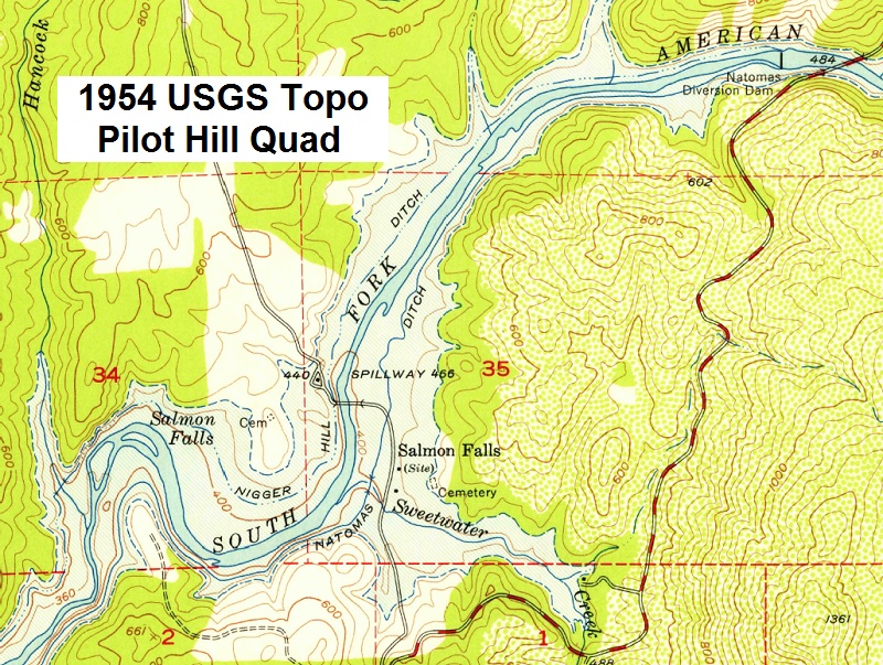
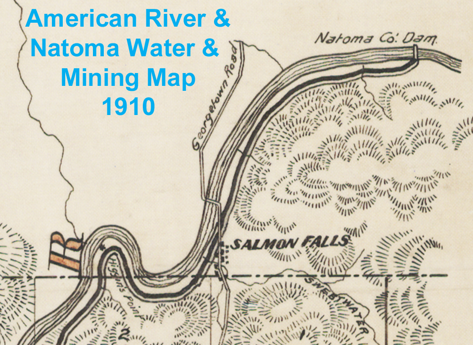
We have records that the North Fork Ditch on the North Fork of the American River was lined with concrete between approximately 1913 and 1917. The Natomas Ditch and the Negro Hill Ditch were probably lined with concrete to reduce water loss to soil seepage around the same time. The Natomas diversion dam was not as large as the North Fork Ditch dam on the American River below Auburn. But you can still see remnants of the base rock blocks that were mortared together with large vertical rods in the rock that would have added stability to the structure. A 1910 map drawn by the American River & Natomas Water & Mining Company only shows one water canal on the south side of the river. A 1954 USGS topo map shows both north and south side ditches, but the Negro Hill or north side ditch is identified with dashed lines indicating potentially only periodic water flow.

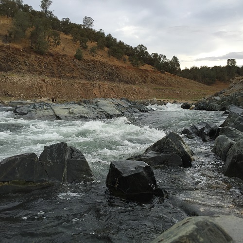
Salmon Falls on South Fork American River as it passes Higgin’s Point. The dark line on the hillside is the shadow of the South Fork Ditch.
1910 map shows Higgin’s Point
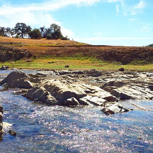
By the 1950’s there wasn’t as much demand for water on the north side since there was no population center such as Folsom. The 1910 map shows the town of Salmon Falls and location of the original bridge. On this map the road to the north of the river is indicated at Georgetown Road. Additionally, the bend of the river cause by a hill west of the Salmon Falls town is labeled Higgin’s Point on the map. I could not find the name or designation “Higgins’s Point” on any other maps. But it is around Higgins Point that the 1954 Pilot Hill USGS topo map indicates the “Salmon Falls”.
Did migrating salmon jump over the waterfalls?
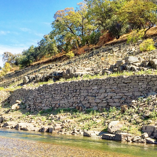
There is a pretty good elevation drop between the old Salmon Falls Bridge and to the west side of Higgins Point. According to the 1954 topo map, the river bed goes from approximately 400 foot to 360 foot in elevation within about a mile of riverbed. This is confirmed by the Natomas Ditch line which rises above the river fairly quickly after the old Salmon Falls Bridge. At the old Salmon Falls Bridge the Natomas Ditch is at the same height as the approach to the old concrete arched bridge. By the time you hike down to Salmon Falls or to the point where the Natomas Ditch cuts around Higgins Point the Natomas Ditch is easily 30 feet above the river.
River water falls, canals remain level
Water canals must have a gentle, if not imperceptible, slope to keep the water flowing by gravity towards it’s’ destination without creating excess water speed. If the riverbed suddenly drops in elevation, the adjacent water ditch must maintain the gentle slope the ditch line can be quite high on the hillside above the river. As the South Fork of the American River, as shown in the photos, dropped in elevation around Higgin’s Point the water would have crashed over the bedrock in the river bottom creating little waterfalls the salmon migrating upstream would have had to jump over.

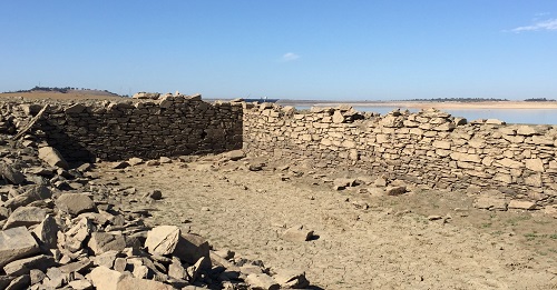
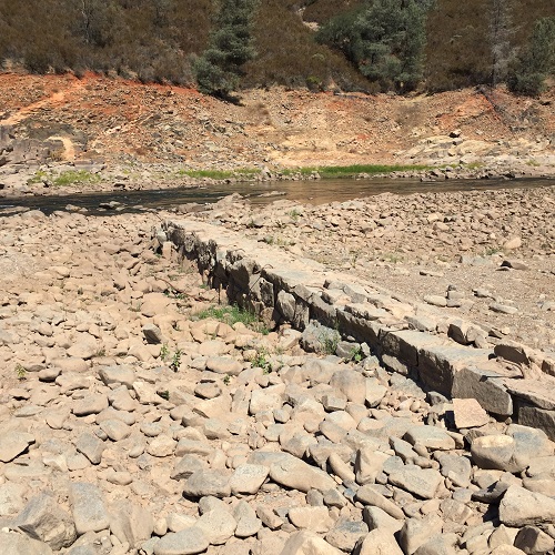
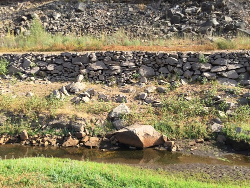
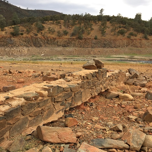
To support the South Fork Ditch along steep hill sides above the river local rock were used to create a retaining wall.
Hand crafted rock retaining walls
What is absolutely amazing is that the rock retaining walls to support the Natomas Ditch on it gentle slope are still intact in most places along this hike. The retaining wall was built in the early 1850’s.These large rectangular blocks of local stone were placed by hand. You can see the engineered approached to building some of the walls to support the water ditch. The Natomas Ditch operated into the 1950’s when the construction of Folsom Dam made obsolete. Today, where not over grown with bushes and trees, the Natomas Ditch makes a great trail because it is flat.
To hike from the current Salmon Falls Bridge to the old Salmon Falls Bridge which is usually covered by Folsom Lake is possibly a once in a life time trek. Do it before Folsom Lake rises so you can see and hear the rushing waters of the South Fork of the American like the natives and migrants did back in the 19th century.
See also: Hidden History Beneath Folsom Lake
View the full 1910 American River & Natomas Water & Mining Company Canal Map
South Fork American River flowing over Salmon Falls around Higgin’s Point (video)
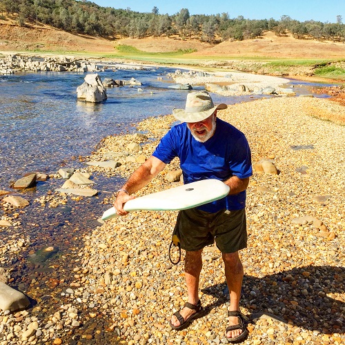
Wading across the South Fork of the American River, October, 24, 2015
Photo gallery, some images can be enlarged by clicking on the picture.


Mormon Island, Richmond Hill and Red Bank
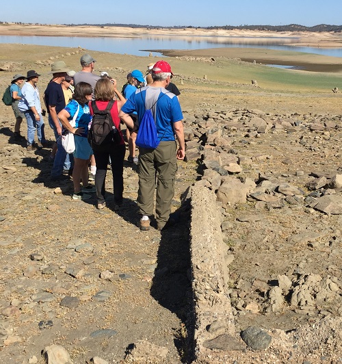
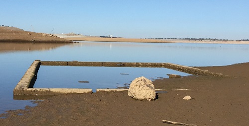
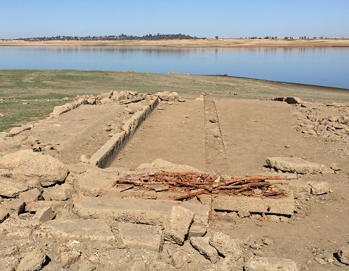
I started out the morning with Mark C and his Folsom Dry Lake Explorers Meet-Up group walking around the ruins of Richmond Hill and Red Bank areas east of the Mormon Island town site that was still under water. The Natomas Ditch was easily visible and the concrete distribution box for the Richmond Hill branch of the water canal is also intact. With the low lake levels the foundation for the Mormon Island School was revealed, the rock foundation of barn in Red Bank, and the concrete remains of a small dairy barn in Richmond Hill were visible.