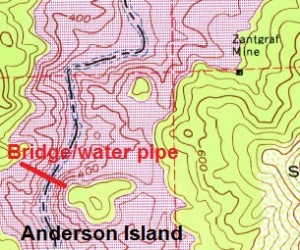
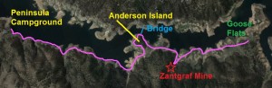
The east side of the north fork of the American River is challenging to hike because of the lack of accessibility and rugged terrain along the Folsom Lake. After I discovered the abutment for a bridge on the west side of the river, I had to get to Anderson Island on the other side. Not only was I able to find the suspension bridge cables, I found the ruins of Zantgraf mine which is fairly well preserved.
Steep sandy and rocky slopes


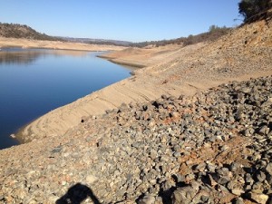
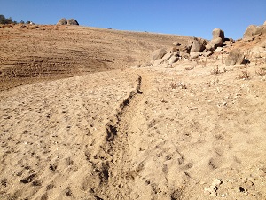
Steep, sandy, rocky slops of Folsom Lake – American River peninsula
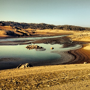
This approximately 10 mile round trip hike would have been much easier if I just had a kayak and paddled across the lake. Of course, with Folsom Lake at historic drought levels it is still a hike to launch a kayak into the water. I started my hike at the Peninsula Campground at the Oak Hills Road boat ramp. The first mile is all steep slopes of sand and rock and I tried to navigate as close to the water as possible.
Hiking shoreline of Folsom Lake
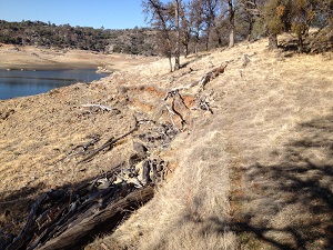
I soon realized there was no reason to hike so close to the water because there was nothing to see and everything to lose; one slip and you’re swimming instead of hiking. Where possible I would hike up to the shoreline of the high water mark of Folsom and walk on the deer trails. At Anderson Creek, or Chrome Creek on some old maps, I started following a cattle trail which made for an easy hike.

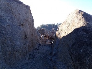
Anderson Island creates narrow river bed
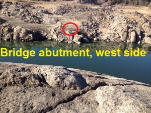
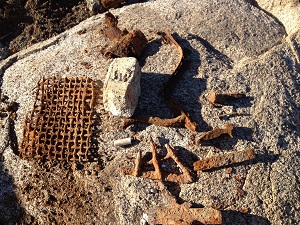
Within the red circle is the west side abutment. Suspension bridge water pipe landing on east side of American river.
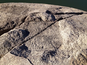
Three miles up from the Peninsula boat ramp I arrived at Anderson Island so named because a full Folsom lake creates an oak savannah woodland surround by water. This also happens to be one of the narrowest spots on the north fork of the American River below Rattlesnake Bar. Anderson Island is a big pile of granite that pinches the river’s flow and was known as the “Narrows” in other historical accounts I have read about mining in the area.
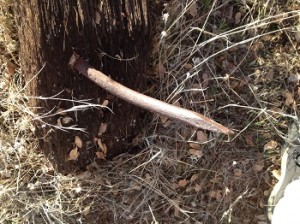
Suspension bridge over American River
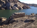
The steep granite face of Anderson Island and relatively steep west side of the river
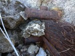
3″ diameter iron posts set into granite boulder, suspension cable wrapped around vertical post was the anchorage for the bridge over the American River in 1897.
make this an ideal spot for a bridge. My research indicates that the owners of the Zantgraf Mine on the east side of the river built a suspension bridge at the “Narrows” in 1897. The bridge didn’t carry people or cars it was for a water pipe. The hard rock mines on the El Dorado County side of the American River required water to run stamp mills, wash the ore and generate electricity.
North Fork Ditch supplied mine water
The west side of N.F. American River had the North Fork Ditch that ran from Auburn down to Beals Bar at the confluence of the north and south forks of the river. While I found the west side abutment, east side landing site, suspension cable anchor points and a cut through granite for the water pipe, the hydraulics of the system don’t completely add up.
Hydraulics of moving water up hill

Cut through granite boulder for water pipe to Zantgraf Mine, Anderson Island.
The North Fork Ditch below Horseshoe Bar Road, across from Anderson Island, is at approximately 425 – 430 foot elevation. The west side abutment is 30 – 40 feet below the ditch and lower than the landing on the east side at Anderson Island. I estimate the landing at about 440 foot elevation based on the proximity to the suspension cable anchor points which are at least 10 feet blow Folsom Lake at high water level.
Inverted siphon across river?
Regardless of the elevation difference across the river, Zantgraf mine is just above the 466 foot high water mark of Folsom Lake. Consequently, even a direct pipe line from the North Fork Ditch to the Zantgraf Mine, 1/2 mile away, would still require water to be pumped up hill. It’s possible that the pipe line used an inverted siphon situation to move water through the pipe as it went over the river. This would be feasible if the pipe line made a sharp descent after the granite cut on Anderson Island down to near river bottom level. Inverted siphons had been used to convey water across the Feather River and from Lake Tahoe to Virginia City. See: Table Mountain Cherokee Hydraulic Mining District
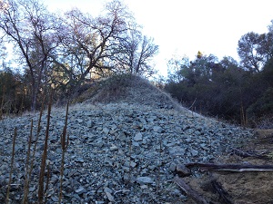
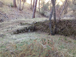
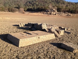
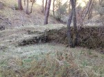
Zantgraf mine stamp mill still stands


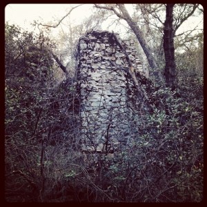
Ruins of Zantgraf Mine stamp mill.
I did find some concrete foundations below Zantgraf Mine that might have been used for a pumping facility up to the stamp mill. When I hiked up the trail of tailings into the ravine where the Zantgraf Mine was situated on old topographical maps I was surprised the stone structures was still present. My exploration of the stamp mill site was limited by a setting sun, which led to poor pictures, safety and not knowing if I was on private property of park property.
Suspension bridge to carry water pipe
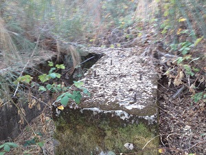
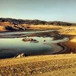
Bridge abutment, American River, 1860’s, low water level of Folsom Lake reveals history.
The Zantgraf Mine was a hard rock gold mine opened between 1882 and 1884. It was producing as much as 226 ounces of gold in a three month period by 1887. At this time the mine had at least a five stamp ore crushing mill and was running a water ditch from the Middle Fork of the American River around Pilot Hill to supply water. The Placer Herald reported that in July of 1897, the Zantgraf Mine constructed a suspension bridge to hold carry a pipe from the North Fork Ditch to their mine operation.
Water generated electricity
Historical accounts from different mining journals and newspaper indicated water from the ditch around Pilot Hill and water from the NFD were used to run dynamos to generate electricity. This may account for the energy to pump the water up the hill to the mine and other concrete posts that look electrical line foundations. Other mining reports indicate that the Zantgraf had expanded to 20 stamps increasing their need for both water and power. Hence, engineering a suspension bridge across the American river to carry a water pipe would help relieve the increasing appetite for water.
Hallidie suspension cable connection?
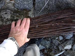
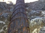
From the fragment of pipe I saw on Anderson Island and other locals I estimate the water pipe to be 18″ riveted cast iron cast iron
Suspension bridge cable, 1897, perhaps Hallidie manufactured
pipe. A few sources indicate that the suspension cable may have come from A.S. Hallidie & Co. in San Francisco. Andrew Hallidie had actually started out in the mining camps of El Dorado and Placer counties before he went on to manufacture wire rope for bridges and trams. Later in his career he designed the cabling system for the San Francisco cable cars. Previous to that he designed suspension bridges using wire cables. See: Cable Car Inventor Andrew Hallidie
Stone cutter to mine owner
Another interesting fact was that the one of owners of the mine, Jacob Zentgraf was trained as a stone cutter either in Germany or Pennsylvania. (Jacob Zantgraf was the nephew to Jacob Zentgraf and acquired a different spelling of the last name.) Jacob’s influence and knowledge of stone work may have led to the stamp mill structure of stone and mortar surviving to this day. See: History of a Place called Rescue, Zantgraf Family, Deer Valley Press
Zantgraf mine failure and fire
Rock retaining wall at Zantgraf Mine ruins
For reasons I have not found, the Zantgraf mine became insolvent in 1901 and went into receivership. There was a subsequent fire at the head works of the mine. In 1903 it was reported to be reopening with a new owner. The last records I found were that the mine was sold in 1908 and became the Montauk Mine and was worked into the 1920’s. See: Mining and Scientific Press and 1908 Los Angeles Herald
Wild Goose Flats
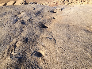
After leaving the Zantgraf Mine in the fading afternoon winter light, I hiked up to Wild Goose Flats. I stumbled across some old concrete foundations, hydraulic mine tailings and some Indian grinding holes. I headed back knowing the real challenge was going to be getting around the steep slopes and rocks closer to the boat ramp. Half way back I heard a dog barking and met up Terry Haney (owner of Knicker Knob Stables in Loomis)who was out for hike also.
Hiking with a new friend
Fortunately, Terry had come down some back roads from her property on Rattlesnake Bar Road and allowed me to tag along with her as a safer alternative to hiking along the shoreline. This little detour added a couple miles and another 300 foot of elevation gain to my hike but it was worth it. This hike isn’t one I would recommend for most people. I can see it being deathly hot and filled with ticks in the spring and summer.
North Fork American river flowing past Horseshoe Bar, January 2014
Zantgraf mine is calling me back
I will be returning to the Zantgraf mine and Wild Goose Flats area to hike again. On my next adventure I think I might commandeer a kayak to shorten the trip and allow for more hiking time.
Video of Anderson Island suspension bridge landing, cut, cables

Gallery of pictures from Anderson Island – Zantgraf Mine hike
Click on the image to enlarge. Three of the images are from a previous post Riding and Hiking along the North Fork Ditch that show the suspension bridge abutment on the west side of the river, square chisel cut for pylon and cast iron riveted pipe. See also other blog posts on the North Fork Ditch and hiking around Folsom Lake at the Folsom Lake Granite Bay page of my website.
Click image to enlarge.