

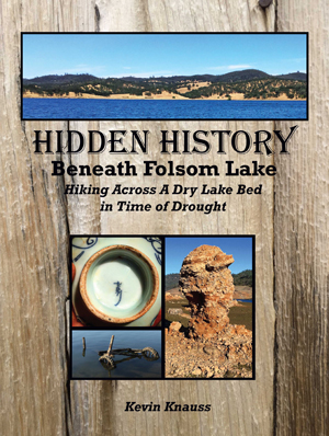
The book Hidden History Beneath Folsom Lake – Hiking Across a Dry Lake Bed in Time of Drought
As the lake level drops, the history is revealed. As Folsom Lake hit record low water levels in 2015, a whole lot of history was revealed. A drought shrunken Folsom Lake of 2015 was the highlight for a guy like me who had been hiking around the reservoir for years looking for historical sites. After numerous hikes around the North and South Forks of the American River at Folsom Lake, I finally organized my photographs and historical research into a book, Hidden History Beneath Folsom Lake – Hiking Across a Dry Lake in Time of Drought.
Pictures and history of the American River under Folsom Lake
For years I had been posting my hikes around Folsom Lake and the American River to the blog on my website. I usually included pictures of the interesting sites I found with a little bit of historical perspective. I also included images of current and older maps so readers could get a sense of where I was along the American River or dry lake bed of Folsom when I discovered the Native American grinding holes, stone mason aqueduct, or remnants of a water ditch rock retaining wall.

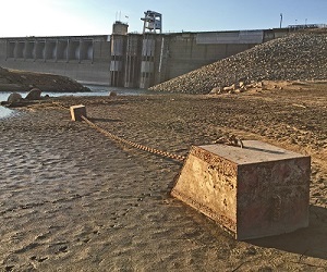
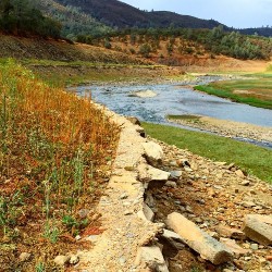
Folsom Lake hit record low water levels in 2015 exposing much of the dam.
History book from blog posts
I thought it would be a fairly quick process to jam all these blog posts into a book. I was wrong. A book is different from a blog post. While the pictures may be the same, a book, at least the one I set out to write, needed more narration and continuity than just a bunch of blog posts slapped together. Plus, I wanted Hidden History Beneath Folsom Lake to be a reference for other hikers in the Folsom State Recreation Area.
The Plimpton collection
An early influence on my outline for a reference book on the various historical sites normally under the water of Folsom Lake was John Plimpton. Mr. Plimpton had compiled several large binders of historical information pertaining to the North and South Forks of the American River under the footprint of Folsom Lake. He started his research and accumulation of data back in the 1960s when he worked for the California State Parks Department.

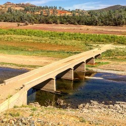
Old Salmon Falls Bridge, exposed by drought stricken Folsom Lake low water levels.
For a variety of reasons, Mr. Plimpton’s research was not published in a formal book before his death. The several binders of his collected notes, photographs, and research have been copied and distributed. One set of binders resides at the Placer County Archives in Auburn where I would spend hours reading through his collection. Because the set at the Placer County Archive is a copy of a copy (and maybe another copy), the photographs are reduced to barely recognizable blobs of black spots.
But as I would read through Plimpton’s work, and viewed the copies of old photographs, I realized I had been to many of the locations he was describing. Not only had I been to places like the remnants of the Birdsall Dam on the North Fork of the American River below Auburn, I had taken a picture of the same concrete structure. Fifty years after Plimpton had documented many of the gold mining inspired projects along the American River from dams, to water canals and bridges, many of these structures could still be located by a hiker and amateur historian like me.
Images of gold rush sites on the American River
Every year, the historical remnants of the gold rush era around and under Folsom Lake deteriorate a little. Water canals get filled with sediment, concrete disintegrates, and metal pipes and suspension bridge wires dissolve from rust. One of my goals in writing Hidden History Beneath Folsom Lake was to document some of the historical sites and artifacts I encountered on my numerous hikes throughout the region.

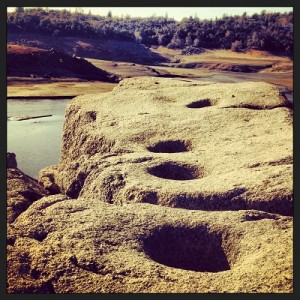
Indian grinding holes over looking American River at drought level Folsom Lake, 1/1/2014
North and South Forks of American River beneath Folsom Lake
Similar to Plimpton, I grouped my findings around the North and South Forks of the American River. I arranged the book in more of a tour narrative starting at Folsom Dam and then traveling up the North Fork up to the Birdsall Dam in Auburn. I then grouped my many hikes on the east side of the North Fork beginning at Wild Goose Flats down onto the Peninsula that divides the North Fork and South Fork of the American River. The final leg of the book chronicles my hikes along the South Fork of the American River up to Salmon Falls.
It was not my mission to write a complete historical account of all the gold mining communities on the American River covered by Folsom Lake. I do include many historical newspaper stories from the 1850s describing the landscape, life and death from the gold mining days and later. Where possible, I include images from old maps from the 19th and 20th century to further document the places and photographs I visited. I’ve even included a table of GPS positions for many of my photographs in the book so other people can locate them more easily.
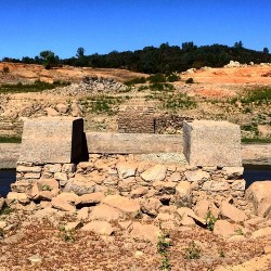
Natomas Ditch winds around Higgin’s Point above South Fork American River near Salmon Falls.
Hiking and history fills my mind
For me, hiking is almost a form of meditation. My mind can’t help but always turn to the questions such as, “Who walked here before me?”, “What did this place look like 100 years ago?”, or “What on earth was that stone structure used for?” To the best of my ability, I’ve tried to answer some of those questions in my book.
What was that thing used for? Who built it?
However, we will never know when the first Native American grinding holes were hollowed out of a granite boulder at Rattlesnake Bar. I’ve haven’t found any information on the stone mason aqueduct south of Horseshoe Bar. I speculate that the numerous mounds of mysteriously piled rocks above Salmon Falls were for the miles water canal retaining walls along the South Fork. But it is only a mere guess.
Crowd sourcing history
Eastern abutment of the ruined Rattlesnake Bar suspension bridge lined up with the western portion of the historic bridge.
My little book is nowhere near as detailed and meticulous as the Plimpton collection. But I do have better photographs. I don’t look at Hidden History Beneath Folsom Lake as some sort of definitive research guide to the history of the region. I welcome suggestions and information from readers. If I have erred in attributing a historical reference in one of my photos or text, I certainly want to know about. If readers have additional research or know of other sites I missed – and I’m sure I did not stumble across every important historical site on my hikes – I will happily consider including that information in another edition of the book.
The Folsom Lake region faces an uncertain future. While the record low of 14% of capacity that Folsom Lake experienced in December 2015 may be a once-in-a-lifetime event, with water being such a precious and scarce resource in California, such low water levels may be common place in the future. Either way, I’ll be out hiking around Folsom Lake and the American River for years to come regardless of high or low water levels.
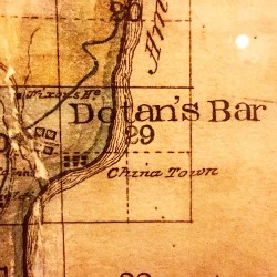
Auburn Courthouse map from 19th century showing Doton’s Bar and China Town, usually under Folsom Lake.
Hidden History Beneath Folsom Lake the book
Hidden History Beneath Folsom Lake is now available in both a print edition or ebook reader versions. The printed version has black and white photographs while the ebook versions have color photographs. The ebook was broken into five separate volumes in order to accomodate the numerous photos and maps because of size restrictions place on ebooks. The first ebook Hidden History Beneath Folsom Lake – Folsom Dam to Rock Springs can be downloaded for free. That’s a convenient way to see if the book is what you are looking for before you purchase the rest of the volumes or the print version. To purchase a copy please visit this webpage Hidden History Beneath Folsom Lake.