1848 Map of Sacramento River, Sutter’s Fort, Leidesdorff, and gold mines on the American River.
On a visit to London to ostensibly see my son who was studying in the United Kingdom my secondary goal was to find some antique clocks to buy. Through the magic of Google maps I was directed to a clock shop around the corner from Harrods Department store. Upon arriving at my destination I learned the clock shop had been closed for five years. As I looked up and down the quaint street of boutique stores I noticed a shop with maps for sale. On a whim I entered the store and asked if they had any maps of California, suspecting that I would receive a polite decline, I was pleasantly surprised when the clerk said he had several drawers of California maps.
Within 10 minutes I had pulled out an 1848 map that showed the relative positions of early California placer mining locations. The map began at the confluence of the Sacramento and American Rivers, and then went east up to the upper mines situated at Coloma. This was better than a clock I thought, so I bought the map and brought it back to its home in the United States.
The Map That Launched The California Gold Rush
On 5 December 1848 President Polk announced the gold discoveries in a state of the union address. The publication included several maps of the western lands that had recently come under the control of the United States including California. Gold had been discovered in January 1848 up at Sutter’s Mill by James Marshall. The United States had a small military presence in the Monterey area. In order to confirm the veracity of the numerous claims that California waterways were brimming with gold, a contingent of military men were sent up on a reconnaissance of the gold mining region outside of Sacramento.
Two officers who took on work of mapping and surveying were Edward Ord and William Tecumseh Sherman. The main map of California was drawn by Ord and was entitled “Topographical Sketch of the Gold & Quicksilver District of California, July 25, 1848. E.O.C.O. L. USA” and was included in Polk’s state of the union address publication Message to the Congress of December 5, 1848 (30th Congress, 2nd Session, House Executive Document No. 1.)

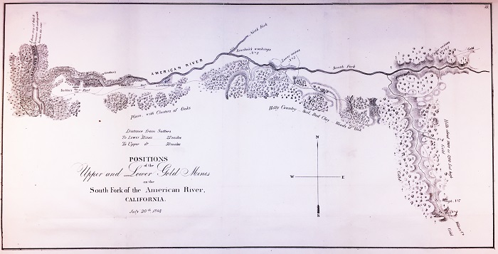
Complete 1848 map in reduced format depicting the gold fields relative position along the South Fork of the American River from Sutter’s Fort.
A larger scanned image of the map is available at the end of the post.
Map Of The South Fork Of The American River Gold Mines
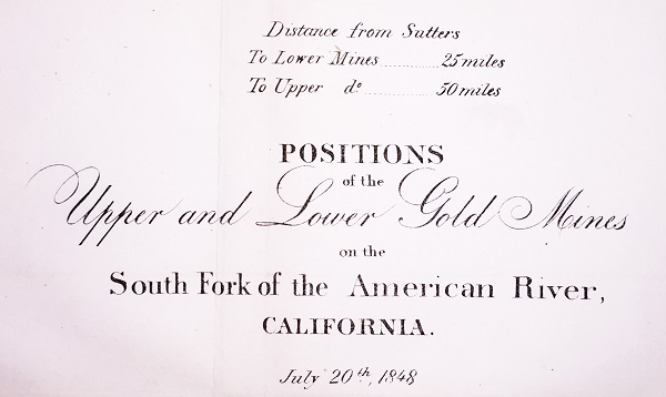
A more detailed map of newly discovered placer gold mining locations was also included in the publication titled “Positions of the Upper and Lower Gold Mines on the South Fork of the American River, California. July 20th 1848.” This map that I purchased in London does not have a cartographer listed. It has been referred to as the Sherman map as he may have been the principal illustrator of the map. Sherman, along with William Warner, was hired to lay out the City of Sacramento in December 1848. This map dated July 20th, 1848 was before Sherman was hired to layout the grid of Sacramento. But it is possible that under the guidance of Sherman and Colonel Mason, Edward Ord actually drew the map as he was the primary cartographer of the larger California map.
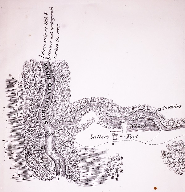
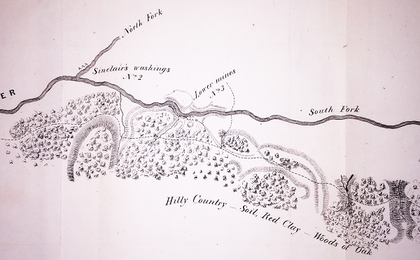
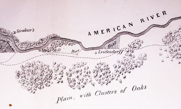
The Upper and Lower Gold Mines map is not to scale. It uses Sutter’s Fort as the base for distances to the lower mines (Mormon Island) and the upper mines near Coloma. The Sinclair house, northeast of Sutter’s Fort on the north side of the American River in the Rancho Del Paso Mexican land grant is shown. John Sinclair became part-owner and resident manager of the Rancho del Paso in 1843, a property that was and still is important to the development of the city of Sacramento. Sinclair was managing the cattle operation of the Rancho Del Paso when gold was discovered. He made his way up to the confluence of the north and south forks of the American River and washed the dirt for placer gold.
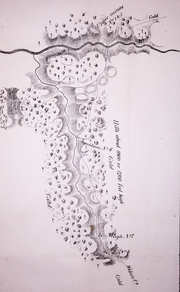
Sinclair’s Washings is listed as gold mine number 2 on the map with Marshall’s discovery in Coloma, the upper mines, being listed as number 1. Lower mine No. 3 is Mormon Bar or Mormon Island. Mine location No. 4 is above Neligh No. 7 and may be the dry diggings of Daly and M’Coon or Lyman’s mining camp mentioned in Mason’s report. No. 5 is a dry diggings location on the north side of South Fork above Sutter’s unfinished mill. If the location of the Sinclair’s washing is remotely accurate, it would be near or at the location of Beal’s Bar, which produced a sizeable quantity of gold in the next year. Either way, Sinclair took his bounty of gold dust and left the state with his family and headed back east.
The map also shows a grist mill race. Essentially, the race was a water ditch allowing river water to enter at higher elevation and then exit back into the river at lower elevation. The flow of water would turn a water wheel to power mill to grind wheat or other grains. There were a couple of grist mills along this portion of the American River. Remnants of one of these grist mill races in located in the American River Parkway in Rancho Cordova. Not far from entrance to the grist mill race the map notes the Leidesdorff house or compound. This is today’s intersection of Folsom Boulevard and Bradshaw Road. Leidesdorff had been granted a large parcel of land from the Mexican government 1844. Unfortunately he died in May of 1848 before the military survey crew visited the region.
It has been pointed out that several features or bends of the American River are not illustrated. I don’t believe it was the intent of the map maker to accurately depict the river but to note its relative position to the mines. The distances of 25 miles to the lower mines and of 50 miles to the upper mines is pretty accurate. The lower mines were also known as Mormon Island for the first group of miners who did extensive mining after the initial discovery of gold by Marshall. The distance to the upper mines, site of Marshall’s gold discovery is also relatively accurate considering hilly terrain that had to be traversed to get to the location.
The survey crew also travelled along Weber Creek. Mine number 4, the southernmost camp visited is close to 10 miles from the South Fork and very close to present day Placerville. The map notes the Sunolaco (No. 6) and Neligh (No. 7 and No. 4) mining camps on Weber Creek. The creek was named after Captain Weber with whom Colonel Mason mentions in his report.
From California Gold Camps by Erwin G. Gudde
Neligh [El Dorado]. Near Placerville, just north of Webers Camp. Shown on the map accompanying Mason’s Report, 1848, entitled “Positions of the Upper and Lower Gold Mines on the South Fork of the American River, California.” Robert B. Neligh, an agent of Commodore Stockton, obtained 2 thousand dollars’ worth of gold here in three weeks. Mason visited the camp in July, 1848, and was given samples of gold. The camp is also mentioned by Lyman (pg. 191)
Sunols Washings [El Dorado]. Antonio Sunol of Sunol, Alameda County, had apparently mined with Sainsevain in May, 1848, at Coloma and Mormon Bar before he went to Weber Creek. His presence on Weber Creek the beginning of July is testified by Governor Mason and in Moerenhout’s account (pp. 16, 23). He and his associates contributed samples of gold to the governor and the latter mentioned the diggings in his Report (30th Cong. 2nd sess. House Executive Doc. 1) as Sunolaco (map with Report) and Lunol & Co. (p. 58 – 64).
Sinclair’s Washings, from Governor Mason’s report
Mr. Sinclair, whose rancho is three miles above Sutter’s on the north side of the American, employs about fifty Indians on the north fork, not far from its junction with the main stream. He had been engaged about five weeks when I saw him, and up to that time his Indians had used simply closely-woven willow baskets. His net proceeds (which I saw) were about 16,000 dollars’ worth of gold. He showed me the proceeds of his last week’s work—14 lbs. avoirdupois of clean-washed gold.
William T. Sherman’s memoir details how Colonel Mason had Sherman and other men accompany him on a visit to the gold mines in June of 1848. Sherman visited Sutter’s Fort and Mormon Bar up to Marshalls gold discovery in Coloma. In none of the recollections that I have read is there mention of who actually drew the Upper and Lower Gold Mines map. It was obviously a collaboration of recollections and notes from the reconnaissance from the various men in Colonel Mason’s party.
What is evident was that the survey crew was taking notes of active mines that were easily accessible at the time. They did not travel up the North Fork of the American River which also had active mining operations. Their mission was to identify and verify the gold mining activity along the South Fork of the American River. They were illustrating known landmarks along the river from Sutter’s Fort up to Coloma as a means of giving perspective to the region. The Mason Report and accompanying map helped set the gold rush to California in full motion.
Sometimes I have to ask myself if I found gold in buying a 170 year old piece of paper or would I have been better off finding an old clock to buy. The similarities are preservation and promotion. I think odd bits of history are worth preserving. Museums and libraries do a good job of preservation, but can fail with promotion. When I speak of promotion I mean promoting more accessibility for novice historians like myself to view historical items and maps.
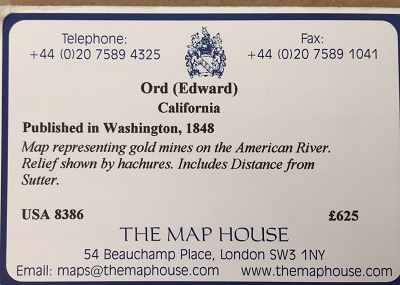
I paid 625 pounds to make a scanned version of the map accessible for anyone to download for free. In essence, I am giving away the very item that I purchased. But I want people to find the map, study it, make comments, and add to the knowledge base about the map. Have some fun on my dime and pass it along when you can. My next task is to get the old piece of paper properly framed to hang on a wall and collect dust. On the upside, I won’t have to wind it every week like I would if it were a clock.
1848 Sacramento Gold Fields Map
Positions of the Upper and Lower Gold Mines on the South Fork of the American River, California, 1848, July 20. Attributed to Edward Ord and William T. Sherman. The map was included in President Polk's State of the Union Address on December 5, 1848, proclaiming gold in California. Map includes location of Sutter's Fort, Sinclair House, Grist Mill, Sinclair Washings, and Weber Creek as it enters the South Fork of the American River.
Map Details