

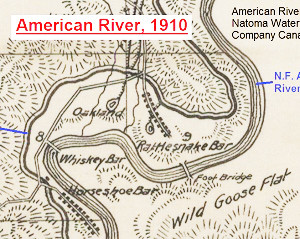
Rattlesnake Bar featured in 1910 map of the North Fork Ditch.
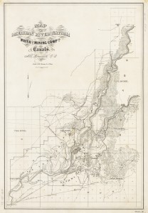
For history buffs there is nothing closer to heaven than examining an old map. I share that fascination and also enjoy sharing old maps that I’ve found. Recently I uploaded a map published in 1910 by the American River & Natomas Water & Mining Company illustrating their network of canals. The map is generally topographically accurate and includes some place names not found on previous or later topographical maps.
This 1910 map is historical and also reminds us that history is not always accurately recorded. In 1909 the North Fork Ditch Company was sold to the American Canon Water Company. A map of the system was produced in 1910. A copy of this map was collected by the Center for Sacramento History. I subsequently bought a digital copy of the map for research. Presented is a scaled down version of the map for quick loading and easy viewing as the digital copy is over 175 MB. Over time I’ll crop some of the areas of interest and magnify them for easier viewing. One such cropped image from the main map is the area of Rattlesnake Bar, shown below.
To download the entire map visit 1910 American River and Natomas Mining and Water Company Canal Map
American River Canal Map
This map traces the North Fork Ditch from its inception at the Birdsall Dam on the North Fork of the American River. Not all of the geographical details, such as the location of hills, are correct. It doesn’t show all of the conveyance structures within the system. For example, between Manhattan Bar and Rattlesnake Bar there was flume across Mormon Ravine, site of the present day PG&E Newcastle Power Plant. But it gives a good overview of the North Fork Ditch and surrounding regions along the N.F. American River in 1910. The map only indicates the Natomas water ditch on the south side of the South Fork of the American River when in fact there was another ditch on the north side of the river. The north side ditch was sometimes referred to as the Negro Hill Ditch because it terminated at Negro Hill which was across from Mormon Island. Note that map maker included the railroad grade for the California Central Railroad from Folsom up to the Halfway House at Old Auburn and Cirby Streets. The CCRR had not been in operation since 1868 and the actual tracks were long gone by the time this map was made.


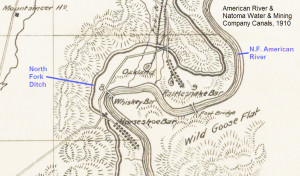
Rattlesnake Bar, 1910
The Rattlesnake Bar detail is interesting because it shows the Rattlesnake Bar bridge from Wild Goose Flat and another bridge across the N.F. of the American River at Whiskey Bar. Prior research indicated that there was a lumber mill at Whiskey Bar and at one time a suspension foot bridge. Not shown is the suspension bridge across the N.F. of the American River below Horseshoe Bar that carried a water pipe over to the Zantgraf mine. Perhaps the bridge at Whiskey Bar was really the bridge carrying the water pipe that connected onto what is today’s Anderson Island when Folsom Lake is full. (To see pictures of the remnants of the old suspension bridge for the Zantgraf Mine see: Anderson Island Bridge and Zantgraf Mine hike)
For more information on the North Fork Ditch and its history you can read the various blogs I have done on it.
- Riding and Hiking the North Fork Ditch at Folsom Lake
- Historic North Fork, Rose Spring Ditch in Granite Bay and Folsom
- American River images before Folsom Lake
- Birdsall Dam, Knickerbocker waterfalls hike at Auburn State Park
- Granite Bay Golf Club uses recycled and spring water for irrigation
- Anderson Island Bridge and Zantgraf Mine hike
- Bureau of Reclamation Attempts To Flood Granite Bay Gold Mine
- Mining Bars, Viaduct along American River Folsom Lake
- Pioneer Express Trail: Rattlesnake bar to Birdsall Dam
- Folsom to Granite Bay: Sacramento, Placer and Nevada Railroad
- Birdsall Dam, Knickerbocker waterfalls hike at Auburn State Park
- Historic Rose and Rock Springs of Granite Bay
- Salmon Falls Bridge to Bridge hike
- Historic Rose and Rock Springs of Granite Bay
- Hiking from Goose Flats to Zantgraf Mine.