

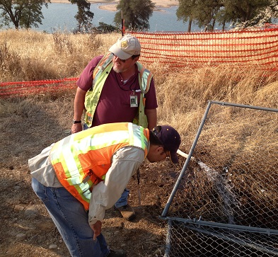
History may be posing a greater threat to the integrity of Folsom Dam than the terrorists. Recent road widening projects and dam improvements have uncovered several gold mining tunnels and shafts precariously close to the dykes which could comprise Folsom Dam. In an attempt to safely probe the depths of a mine shaft between dykes 4 and 5, the Bureau of Reclamation pumped several thousand gallons of water into a large pit on top of the ridge this past August, 2013.
Bureau of Reclamation pumps water mine shaft opening
The large pit, 6 feet round and 11 feet deep, was most likely a mine entrance and air shaft [Granite Bay Gold Mine]. Mounds of disrupted soil directly line up with a tunnel opening one hundred yards to the north and below the mine entrance. The hope was that by pumping copious amounts of water into the pit the water might surface like an artisan spring somewhere on the hillside giving an indication of the subterranean tunnel network.
Granite Bay gold tunnels still a mystery
Additionally, there was the goal of potentially opening up the bottom of the pit or sides to reveal its true depth. Sadly for the Bureau of Reclamation crew conducting the water pumping test, the mine shaft failed to give up its secrets. While the bottom of the pit was slightly deepened from washing away the accumulation of dirt and debris collected over the last century, there were no profound discoveries either in the pit or around the hillside. The pit and tunnel network just absorbed all the water dumped into it.
The earth swallowed all the water

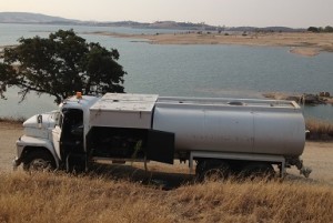
Juxtaposition of the water truck holding 2,000 gallons of water to be pumped into the mine shaft next to a shrinking Folsom Lake below.
As the pump kicked on and a stream of water poured into the pit, I felt a slight sense of futility. This huge pit with one known opening 300 feet away coupled with dry porous soil could easily drink up a couple thousand gallons of water. Within thirty minutes all the water had been pumped into the pit and there was nary a drop of standing water in the bottom. But this low cost exercise was not a failure. The Bureau now knows that this old gold mine is fairly extensive, even if more research needs to be conducted.
Unknown mining tunnels discovered
This Granite Bay abandon mine poses little threat, if any, to the integrity of Folsom Dam because of its elevation above the lake. However, a gold mining tunnel discovered during the dyke strengthening project several years ago was next to the earthen fill that makes up dyke 4. A dozer uncovered the tunnel that extended quite a distance into the hillside. It took over 260 cubic yards of concrete pumped into the tunnel to secure it according to Steve Sherer, Senior Engineering Geologist, with the Bureau of Reclamation.
Hidden tunnels pose a threat to Folsom Dam integrity
Another mining tunnel was found during the widening of the Auburn-Folsom Road a couple of years ago near dyke 6 and Beals Point. Much to the chagrin of the Bureau, the old mining tunnel may not have been properly filled and sealed by local authorities or contractor. Just like a gopher can create a network of tunnels weakening a river levee, these old mine shafts have the potential to accumulate water, collapse or slump leading to a weakened dyke system.

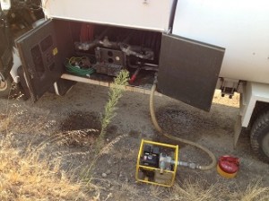
Centrifugal pump pushed water up the hill and into the mine shaft through canvass fire hose.
Detective Sherer
In a continuing effort to locate and map these various old mining tunnels around Folsom Lake, Steve Sherer, noticed some pictures I posted on Panoramio of the pit which shows up on Google Earth. He contacted me and I showed him where the north tunnel entrance was located which is on private property. Steve, a geologist by education and gold explorer by heart, discussed with me the geology that makes up the area around Folsom Lake.
Thars gold in dem hills
The unconsolidated cobble and dirt that caps the granite base around the lake is known as lahar. This material flowed down from from the Sierra thousands of years ago during volcanic events. The large smooth andesite rocks embedded in the lahar look like the material miners had to remove in order to reach the bedrock in the American river where most of the placer gold was located.
North Fork Ditch provided water to wash the “dry diggins”
It wouldn’t be unreasonable for a gold miner in 1860 to conclude that there might be gold underneath the lahar on the ridges around the river. As Steve explains, the miners may also have been chasing quartz veins that are visible above ground in the hope that it would lead to a deposit of gold. Since the North Fork Ditch was completed by 1858, with a spur that wrapped around the base of this particular ridge, the miners had access to water to wash their “dry diggins” pulled out of these mining tunnels.
More cobble rocks than gold
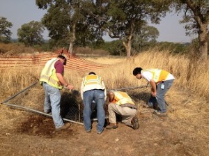
Bureau of Reclamation staff try to determine if the pumped water revealed anything new in the bottom of the mine shaft.
Based on the geology, history and his own experience, Steve doubts that much gold was ever recovered from these mining operations. One can’t help but marvel at the man power employed to excavate this large mine shaft with rocks easily weighing upwards of 30 or 40 pounds. The assembled Bureau crew speculated that the timbers at the base of the pit might have been from a ladder or wood to secure the sides. There is also the possibility the wooden remnants might have been from a small head frame used to lift the rocks and dirt during excavation.
Safety first
From the stand point of safety, the Bureau of Reclamation would like to fill the pit so animals, people and horses don’t tumble into it. But before they just fill it with concrete they would really like to know the extent of mining tunnel network. 58 years after the completion of Folsom Dam the Bureau of Reclamation is still discovering and grappling with the gold mining history on the American River.
