

California Central Railroad: Folsom to Roseville.
The California Central Railroad had its genesis with the failure of the Sacramento Valley Railroad (SVRR) to complete its original concept of running a railroad from Sacramento to Folsom, and then up to Marysville. Colonel Charles Lincoln Wilson, who was instrumental in getting the SVRR organized and running in 1852, was the driver behind the California Central Railroad (CCRR) which ran from Folsom to Lincoln, California. While little of the original railroad grade remains today, many suburban streets utilize the original road cuts and parts of the old grade can be seen in Orangevale Park and along Linda Creek in Roseville. I used historical maps from the SVRR and the Central Pacific Railroad to verify the alignment of the CCRR line from Folsom to Roseville. The line from Roseville up to Lincoln is still in use by the Union Pacific Railroad.
Discovering The Central California Railroad

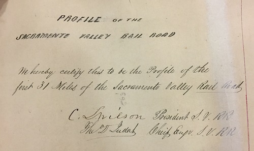
Profile Of The Sacramento Valley Rail Road, Chief Engineer Theodore Judah, C. Wilson President, 1854. Courtesy of the California State Archives.
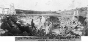
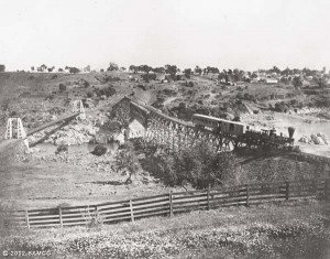
In 1854, then President of the SVRR, Charles Lincoln Wilson traveled back east to find someone who could engineer the railroad. He hired Theodore Judah who had been working in the railroad industry for several years. Judah was named Chief Engineer of the SVRR and, once in Sacramento, went to surveying for the road. Because the SVRR master plan called for the railroad to travel north, Judah located a good place for a bridge across the American River would be at Negro Bar.
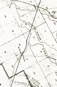
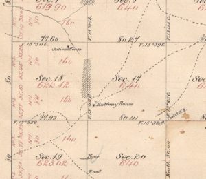
In July 1854 Judah submit his report and a map of the profile of the SVRR for the first 31 miles. The distance to Folsom, then Granite City, was 22 miles. The next 9 miles was the road from Folsom to just north of Secret Ravine. This would be at the later intersection of the Central Pacific Railroad through Roseville. The 1854 map by Judah shows the rail line crossing over the American River, passing next to the Halfway House, and finally crossing over Secret Ravine, known today as Dry Creek.

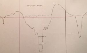

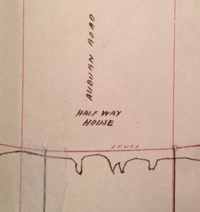

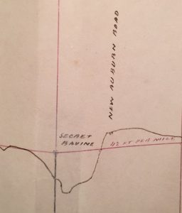
We have historical photos that show the location of the bridge across the American River. That Judah indicated the Halfway House on his original map is significant for placing the rail line along Linda Creek through Orangevale and into Citrus Height. The Halfway House was the approximately halfway between Sacramento and Auburn on the old Auburn road. While the notation of Secret Ravine doesn’t indicate where across the creek the rail line was to travel, it still helps to place grade in the vicinity of Roseville.


The SVRR, for all of it grand plans to monopolize rail routes in the valley, faced constant financial difficulties. Even though Charles Lincoln Wilson helped raise the initial capital for the SVRR, he was ultimately pushed out as President. But after the SVRR started actually running in 1856 from Sacramento to Folsom, and generating much needed revenue, it was decided to push for an extension of the line up to Marysville.
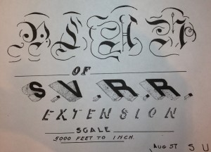
In 1857 the SVRR filed a map for an extension of the rail line. The Chief Engineer was not Theodore Judah, but J.P. Robinson. It would not be unreasonable to assume that J.P. Robinson leaned heavily on Judah’s original design from 1854, if not an actual duplication. In either event, it is likely that both the Judah and Robinson layout from Folsom to Roseville was the most economical.


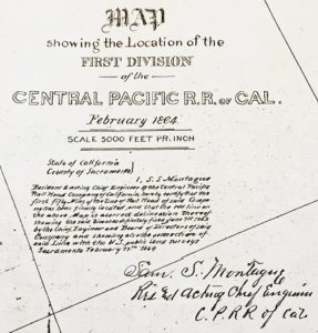
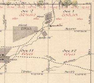
While SVRR was planning the extension, Charles Lincoln Wilson incorporated a new company called the California Central Railroad in 1857 with Theodore Judah as Chief Engineer and Wilson as the appointed contractor. I have found no actual map filed, thus far, with the state by the California Central Railroad, but it’s probably floating around someplace. However, in 1864, the Central Pacific Railroad filed a map of their lower division from Sacramento to Auburn. On it the CCRR is depicted in the relative alignment indicated by the SVRR extension map.


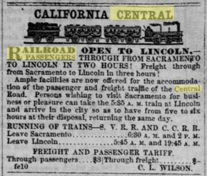
The CCRR was able to build the fairly substantial bridge over the American River by 1859. They reached Lincoln, CA, in 1861. When fully operational, the CCRR had 18.5 miles of track, four locomotives, four passenger cars, and 16 freight cars. They operated daily round trips from Sacramento to Lincoln via a connection to the SVRR at Folsom. Round trip fare was $3 and freight was $4 per ton. At Lincoln, passengers could take the Oregon Stage to points north or the communities along the Yuba and Feather Rivers.

Several years ago I was involved in a conversation with friends about a railroad line that went from Folsom to Roseville. Even though no one really seemed to know the route, they were all full of speculation. At the time, I did a little bit of research and was able to get copy of a map, filed by the Sacramento Valley Railroad for a route in 1857. Unfortunately, the map was essentially the railroad line, distance, angles, radius, but no physical features that would aid me in transferring the line to a modern day street map.
Fast forward a couple years and I’m able to devote more time to researching the history of the Folsom to Roseville railroad. This is not a scholarly or definitive work of research on the subject. I have tried to accumulate different bits and pieces of the puzzle to give a more complete picture. An in-depth analysis would require translating Chief Engineer Robinson’s angles and distances. That was beyond my scope since I am not an engineer and have not had the time to educate myself in the nomenclature. Plus, the ultimate route was not built by the company that originally filed the map. Consequently, the final railroad grade may have been different.
Maps, maps and field work
What I have attempted to do was look for as many physical clues still present today along with historical photos and old United States Geological Service Topographical maps, usually 7.5 x 7.5 minute. While I am pretty certain about the first mile and the last couple of miles, there is an area in Orangevale that provides very little clues as to the exact route. From the Sacramento Valley Railroad map, and old topographical maps, I can see a couple different possibilities. If you think the railroad may have run through a property you are familiar, I would like to document it for posterity.
The first railroad in California, the Sacramento Valley Railroad (SVRR) completed its main line in 1856 from Sacramento to Folsom. As always seems to be the case in the early years of railroads; the investors, managers and engineers were always fighting with one another. When the president of the SVRR left and formed the California Central Railroad, the SVRR immediately commenced making a map for submission to the State of California for the right of way from Folsom up to Marysville. The SVRR Extension was dated September 21st, 1857.
I have been told (which is not a substitute for evidence) that the route had been originally surveyed by SVRR’s first engineer Theodore Judah back in 1854. It has been speculated that the subsequent SVRR map follows the original line with potential improvements from Chief Engineer Robinson who was not a big supporter or friend of Judah.
Correspondence regarding the Folsom to Roseville line
THURSDAY, JANUARY 07, 2010
Railroad Map Survey Nomenclature
The California Central did indeed build a portion of railroad planned by the SVRR. Indeed, the president of the CC, Charles Lincoln Wilson was the ousted president of the SVRR, and was intent on fulfilling his initial ambition of building a railroad to the head of the Sacramento Valley (thus that railroad’s name). Robinson’s June 1857 location survey northward was an immediate response to Wilson’s organization of the CC in April 1857. The SVRR was not at first willing to abandon its northward ambition to Wilson and the CC.
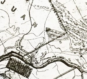
It is also very likely that the CC’s location was also close to Judah’s 1854 line since Watson had been Judah’s assistant when the 1854 location was established, and Judah would likely have favored his own 1854 line after he joined the CC in 1858. However, it is possible that Robinson “improved” on Judah’s line (after all, Robinson didn’t like Judah). Too, Watson may have made his own “improvements” when he made the initial location for the CC (Watson had a mind of his own). And, Judah may have made further “improvements” to the line when actual construction began. In any event, there certainly appears to be a minor difference between Robinson’s 1857 line and the railroad as built between the site of Orangeville and the site of Roseville. The as-built line (of Montague’s map) shows four curves along what I think is Plummer’s Ravine (about half way between Orangeville and Roseville), while Robinson showed that all tangent. – Wendell Huffman
Regardless of the SVRR desire to build a line from Folsom to Roseville and beyond, it was the newly organized California Central Railroad (CCRR) that started construction in 1858. They completed the line all the way to Lincoln on October 31, 1861. When the Central Pacific Railroad, part of the transcontinental railroad building, reached Roseville in 1864, the value of the CCRR diminished in value. The Folsom to Roseville line was shut down in 1868.
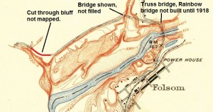
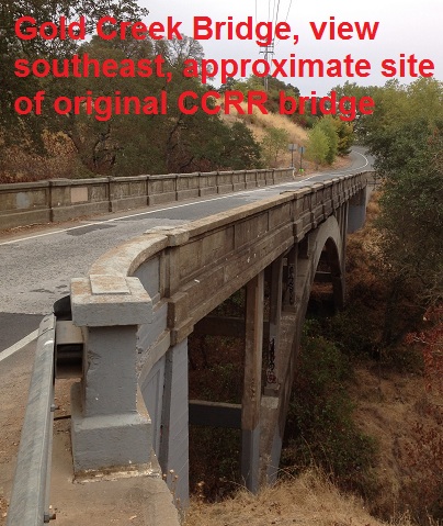
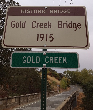
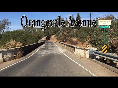
Significant remnants left from the CCRR are the first railroad bridge over the American River that would eventually become the Rainbow Bridge, the cut in the north side bluff that would become Greenback Lane, the Orangevale or Gold Creek Bridge, and Folsom street in Roseville.
Early Maps
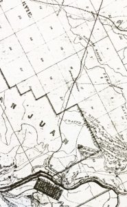
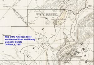
The earliest maps of the area are from Government Land Office (GLO), the predecessor of the Bureau of Land Management. Even though both the CCRR and CPRR were in existence when the 1865 and 1866 maps were made, they don’t show the rail lines on the maps. The GLO maps, in addition to showing sections of the Township and Range they were based on, due note fields, wagon roads, creeks, fields and homes. The 1865 map of Township 10 North, Range 8 East, Mt. Diablo baseline meridian, does indicate the Halfway House. But sadly, nothing about the railroad that certain was running by it. A 1910 Water Canals map shows the CCRR from Folsom to the Sacramento – Placer County line, including the Halfway House.


United States Geological Service (USGS) Quadrangle Topographic Maps
Call me obsessed or mentally ill, but just knowing the CCRR existed is not enough for me. I want to know where it actually ran. If at all possible I want to stand on the spot that it traversed. Suburban development has forever erased the footprints of early settlers. A glimpse of the past occurs in old topographic maps from the United State Geographical Service (USGS).
While none of them showed any trace of the CCRR line, the elevations, creeks and outlines of dirt roads can all give clues. Even 60 years after the CCRR was initially built, the topography illustrated on the USGS maps would have been virtually the same. With this set of facts, I set about to re-creating a route that:
- Resembled the 1858 map
- Lined up with the known points of the CCRR
- Would represent the most efficient, least costly route
- Took into consideration local anomalies that may have been created because of the CCRR line.
Sacramento 1892 Quad
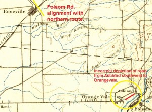
The first comprehensive topographical map of the region shows the town/depot of Ashland. The initial CCRR grade is shown as a gravel road traveling to Orangevale. Folsom Road, perpendicular to the Southern Pacific RR, is the only other indication of a rail road that existed 30 years earlier. There are some real issues with this map, how roads line up, angles, etc., that prevent it from being historically accurate with respect to the location of man-made landscapes. The Ashland Depot would be moved to the City of Folsom in 1976.
Antelope 1911 Quad
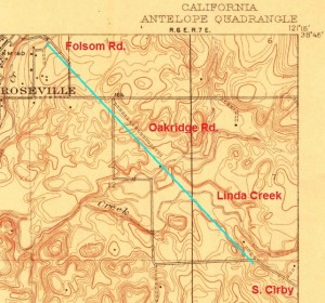
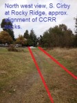
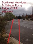
In one of the earliest complete quadrangle topographical maps of the area, it is clear that the original Folsom Rd that would intersect perpendicularly with the Southern Pacific RR tracks, if extended would line up with dirt road south of marker 164. If you continue on the line, it would link up with the dirt road spur which is the present day intersection of Cirby and South Cirby roads. I have little doubt that the dirt roads depicted continuing onto South Cirby was the original CCRR line.
Folsom 1914 Quad
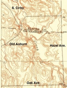
The 1914 topo quad map shows South Cirby intersecting with Old Auburn. Lost is any indication if the CCRR tracks paralleled Linda Creek on the south west or north east side. A dirt road, BM 203, may have been part of the old road bed, but this may be at odds with the tracks crossing Oak Avenue several hundred yards to the east of its intersection of Hazel Ave.
Much of the 1914 topo map is just blank. Perhaps World War 1 interrupted a full map from being made. Even the portion containing Negro Bar and the cut leading up to the Gold Creek Bridge was not finished.
Folsom 1944 Quad
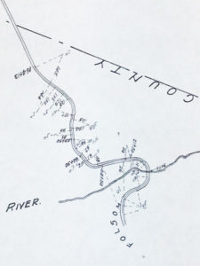
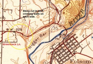
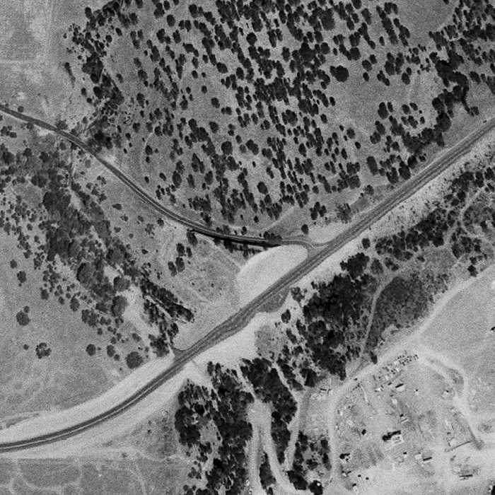
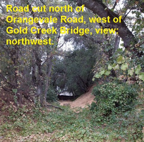
The next full topographical map I could find was completed in 1944. Significant on the Greenback portion is that the railroad curve cut into the hillside, also known as Lincoln’s Cut, is clearly shown with the road way turning to the northwest to meet the Gold Creek Bridge. In 1944, Greenback had not been extended over the steep creek ravine. Some maps I have seen indicate that there was a bridge over the drainage area at the X marking the Bench Mark (BM) 225. X marks the spot of the railroad cut into the hill that took the CCRR northwest to Roseville.
A larger image of the 1944 map shows much of the elevations missing from the 1914 map. Absent on the 1944 map is the dirt road at BM 203 that traveled up the southwest side of Linda Creek. Instead, we find a dirt road several hundred yards north of the intersection of Oak Ave. on Hazel. The original 1857 SVRR map showed a curve in the tracks that would indicated a grade that would take the tracks to the north and west of intersection of the 3 different creeks that converge north of BM 203.
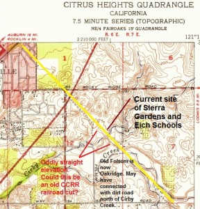
Citrus Heights 1951 Quad Map
From the bottom right hand corner where South Cirby intersects with Cirby, there is a finger of a dirt road shown. This could have been the old railroad bed. The yellow line is placed parallel, northeast, of the suspected CCRR route. Notice the 150′ elevation line northwest of the (Linda) Creek is in alignment with the dotted dirt road line that eventually would connect with Folsom Rd. on the other side of Interstate 80. I believe the cartographers mapped the cut of the railroad before the Sierra Gardens Elementary School was built in 1956.
The street Old Folsom Rd. shown in the bottom center of the image indicates that at one time it probably connected to the reconfigured Folsom Rd. on the northwest side of Interstate 80. Old Folsom would subsequently be renamed Oakridge Dr. My guess is that the nice straight 150′ elevation line crossed the Cirby Creek at the site of the the present day student access bridge from Gregory Way.
Folsom 1954 Quadrangle
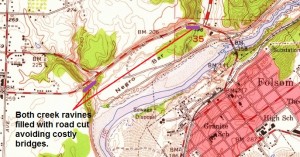
10 years after the 1944 Folsom topographical map was completed, not much had changed in the Orangevale area. The Lincoln Cut is still depicted and Gold Creek is now full of dirt which enabled Greenback to connect the original alignment of the CCRR cut above the renamed Negro Bar without constructing a bridge. How convenient that an 80′ deep, 200′ wide ravine suddenly filled up with rock and dirt between 1944 and 1954.
By 1954, the Topo maps had dropped the previous racial slur in favor of Negro Bar on the maps. Greenback Lane has been extended to connect to the original railroad line. The town of Ashland no longer appears. Still prominent was what became known as the Lincoln cut through the hill side to connect with the current Gold Creek Bridge built in 1915.
Notice that where Greenback crosses Gold Creek before connecting with the original RR grade and before it connects with Auburn-Folsom Rd., Topo maps no longer show elevation changes down to the creek level but represent the rock fill to build up the road base. The Gold creek crossing infill is 80′ high (235′ – 155′) and the Auburn-Folsom infill is 27′ (195′ – 168′). In both instances, there is a 3′ to 4′ corrugated drain pipe allowing the creeks to continue to flow. While these are minor ephemeral creeks that would only flow during the winter, no road construction today would allow for a creek to be so blocked.
Orangevale 1954 Topo Map
While the south end of the line in Folsom and the north end near Roseville are easy to determine, the middle section through Orangevale is open to interpretation. I used a 1954 USGS 7.5 minute quad map to generate an approximate grade elevation through the Orangevale area. The 1954 had the least amount of suburban clutter with the best detail of dirt roads and elevations. A more detailed map was made with Google Earth.
The most exciting and affirming route location was finding what I am fairly certain is the old CCRR grade through the Orangevale Community Park and along the City of Roseville Open Space area along Linda Creek.


Printed Ephemera
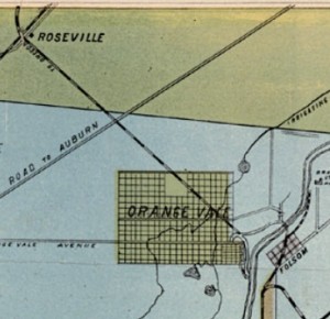
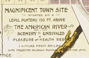
Even after the CCRR was defunct, the marketing aspect of a railroad from Folsom to Roseville was still used to lure people to the newly developed Orange Vale Colony. The Orangevale Colonization Company was formed in 1887 to market 312 ten acre parcels plus a small village north of the American River adjacent to the City of Folsom. A Sacramento Union newspaper lithograph from 1890 shows a train crossing through Orangevale.7
Important to the marketing plan was irrigation water from a local ditch from the American River, access to Folsom via bridge to the railroad and a faint marketing wisp of the old CCRR line that cut through the northeast corner of the colony. The old CCRR line, 20 years defunct with the rails long removed, seemed like an odd marketing premise. While the prospect of a rail line to Folsom or Roseville sounds nice, who would knowingly buy a plot of land that, would one day be cut by an existing or new railroad?6
In 1909 they were still promoting some form of rail transportation.
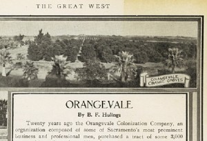
The Sacramento and Sierra Railway, an electric line now being built to connect Sacramento with Lake Tahoe resorts points, will pass through Orangevale and afford rapid and frequent communication with the Capital City. Orangevale will be a commutation point, and an hourly service is promised, which will make this the choicest suburban residence district of the city.- B.F. Hullings One page of a reprint from the “Great West” with text by B. H. Hulings promoting Orangevale Colony and its orchards. Illustrations include orchards, Orangevale homes. In: “The Sacramento Valley of California”, page 50; originally published in the “Great West”, Vol. IX No. V, September 1909.
Whether the author was speaking about plans to rekindle the old CCRR line into an electric railway or some other proposed trolley line I am not sure. I have been unable to locate anything about the Sacramento and Sierra Railway electric trolley line.
Center Mississippi Township
In a book on Citrus Heights history there is a map of the Center Mississippi Township, the bulk of which was to become Citrus Heights, with the complete CCRR line running from Folsom up toward Roseville.1 Also in the book is the lithograph of the Cornelius O’Donahue ranch in 1862. Off in the top of the print on the horizon of the ranch is a train steaming across from left to right. If the drawing was actually made in 1862 it could only be the CCRR because the Central Pacific did not pass in vicinity until about 1864.2


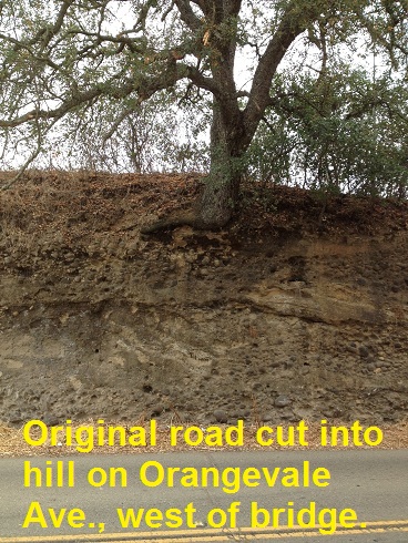
Lincoln Cut
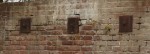
As a young boy I remember traveling down Greenback Lane from our house in Citrus Heights to the Folsom Rodeo and seeing this enormous rock wall that looked like is should collapse. The enormous rock wall was the remains of what became known as the Lincoln Cut as the CCRR railroad cut through the north side bluff of the American River to take the rail line north. I speculate that the high rock wall little path was assigned the named “Lincoln Cut” when the route was designated as an auxiliary route for the Lincoln Highway in approximately 1916.
A local history book, full of great images of the Lincoln cut, is Images of America, Orangevale. There are several good images of people and cars traveling though the cut along with a paving crew in the early 20th century. It also has a great early photo, approximately 1941, of the CCRR road cut on Orangevale Avenue 8, 9, 10, 11, 12,13 and another picture of the Lincoln Highway identified as Orangevale, but what I believe to be Ashland north of Folsom.
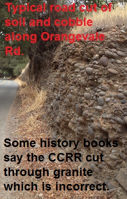
Unfortunately, the book has a few errors, one of them is that the author states, “[CCRR] made two cuts along the American River’s tough granite bluffs…” Actually, all the cuts were into alluvial consolidated soil and very little if any granite was cut. The bluffs along the American River are comprised of layers of sediment, cobble rock, clay and silt which are relatively easy to cut through.
While I would love to put all the photos I have come across into this post, copyright protections prohibit that at this time.


History Revealed and Nibbled
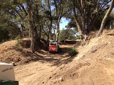
While driving down Orangevale Ave in early October, 2013, I notice grading work being done on the CCRR cut. I stopped and inquired with the gentlemen working to fill up the dump truck and they informed me they were getting the lot ready for the construction of a new home. It was interesting to see the depth of the original CCRR cut into the hill.
The construction crew informed me that the property owner was aware of the history of the site and how the California Central Railroad ran through the lot. Additionally, because the size of the oak trees around the cut and the regulations surrounding heritage oaks, it was unlikely that the banks of the cut would be completely wiped out. To be honest, I am a little bit envious of the property owner. How many people get to build on a piece of land with such a provenance of a historic railroad having passed through their property 160 years earlier?
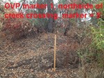
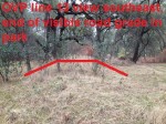
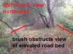
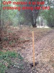
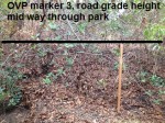
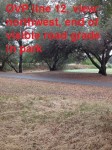
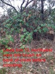
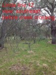
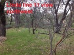
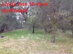
Orangevale Community Park (OVP)
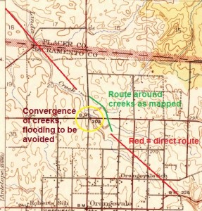
After I studied the approximate location of the route from the 1857 SVRR map and looked at old topo maps, I determined that deflection of the near straight line from Orangevale Avenue to Roseville had to be around Orangevale Community Park. East of the intersection of Hazel and Oak Avenues is the confluence of several minor creeks. As small as these creeks are, they would have created a very uneven landscape and represented a flooding hazard. Certainly no railroad engineer would want to hassle with running a line through all these creeks and hills.
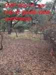
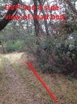
Old railroad bed discovered?
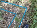
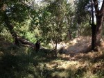
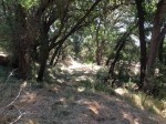
It wasn’t until the end of my hike all over the park that I finally saw the raised landscape feature. The most striking aspect is that the berm, over 4′ tall, was bisected by a small creek. There was no indication that this small ephemeral creek could erode through this bank of dirt. Obviously, this was some sort of elevated feature to cross the creek; it had to be the railroad. Even though it is overgrown with bushes and trees, you can still discern how flat the top of the bank is and how it’s relatively straight from the starting point near Filbert Rd. Had this been some sort of levee, it would have directed the small creek to another creek a couple hundred yards away.
It all fit together that this straight, flat earthwork was the CCRR grade designed to skirt the confluence of multiple small creeks. Fortunately, this part of the park has been left untouched and wild. Other portions of the park and private property have obliterated any traces of the rail line.
The geo-positioning or GPS coordinates associated with the photographs I took with my camera phone helped confirm the grade. While they are not perfect, the coordinates provide a pretty good line on which assign the rail road grade. All the photos of this section of the CCRR grade start with OVP for Orangevale Park.


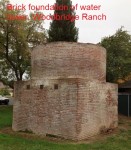
Woodbridge Ranch
A large portion of where the CCRR must have run is through the private homeowners association of Woodbridge Ranch. While driving through the area I was surprised to see the foundation of a brick water tower. Upon conversing with a member of the homeowners association, he mentioned that the water tower was built by the former ranch owner to provide water for his cattle operation. In addition he mentioned that a historian several years earlier had determined that the CCRR line had run too far to the southwest for the water tower to have any connection to the line.
It is certainly possible that the CCRR never ran past the point that the water tower is located. Although, I can plot a line route that put the CCRR grade traveling right past the tower. This brick water tower is fairly substantial in construction and I am not entirely convinced that a cattle operation would warrant the significant investment to build such a structure.
The structure is also reinforced with rods and plates on the outside similar to those used in at the old Southern Pacific Railroad shops in Sacramento. Although, such reinforcing mechanisms were common with load bearing brick structures of the time. In my limited search for brick constructed water towers, I have yet to come across a North American railroad that built a water tower similar to this one. There is always the possibility that the brick water tower was built for a larger and as yet unknown business venture beyond just cattle.


Update to Original Post: Old Auburn, South Cirby Intersection; May 10, 2013
It’s always a challenge to document a historic place or event when it is located on private property. My good luck was that Gary Nesheim saw this blog post and called me. From a conversation with his father, he was fairly certain the CCRR had passed through what was now part of their property east of Old Auburn Blvd.
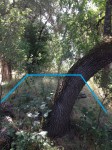
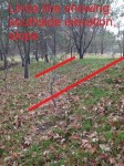
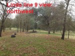
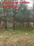
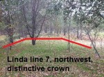
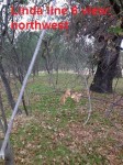
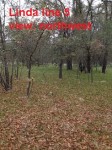
Gary’s father had spoken with someone researching the CCRR years ago but the report on the rail line has been lost. But a rail road was never to unrealistic to Gary’s dad who had found some old rails on the property and incorporated them into a bridge over Linda Creek. There is a wide swath of the CCRR that passes through private property from the corner of Oak Ave. and Hazel up to South Cirby. The moment Gary first showed me the unnatural berm cutting diagonally across his property I was fairly certain that was the old rail road bed. Gary knew where the county had laid the sewer line so the straight hump of earth could not have been from utility work. The low rise berm would not have been created by Linda Creek flooding because it bisected the creek flood plain as opposed to being parallel to the creek bed.
We drove around to the southeast side of Linda Creek and a man-made rail road cut was readily apparent. As the rail line approached the Linda Creek crossing there is tall berm which would have connected to a bridge. You can follow the approach south as it changes from elevated berm to creek side road cut. All of this is in a straight line along the expected path of the CCRR. There is even a small drainage swale between the old road bed and cut embankment.
I poked around further along Old Auburn Road and found a concrete foundation for an out building of approximately 10′ x 10′. While it is doubtful that this was present at the time the CCRR was in operation, we do know that the line passed by the “Halfway House” The Halfway House was half way between Sacramento and Auburn at the 18 mile mark. Old Sacramento Union notices show that a Frank Brown acquired the Halfway House from partners Rosecrans and Cutts in 1852. (Sylvan Recollection, A History of the Sylvan District by Lillian A Cross, 1943). The structures burned down in the 1950’s.
Thanks to Gary Nesheim for providing me access to the property to take photos and document part of the California Central Railroad line.

Linda Creek
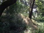
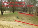
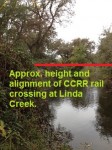
The big question I had was; did the CCRR line run on the northeast or southwest side of the creek? It is fairly subtle, but I did stumble across another raised landscape feature, approximately 6′ – 8′ feet wide at the top, with a height of 6″ to 24″, running in a straight line. This raised landscape feature would intersect Linda Creek at a perpendicular crossing. As with the grade in Orangevale Park, there were places that had a drainage swale on either side of the road bed.
I would not have expected the elevation near Linda Creek to be as high as that of the crossing in Orangevale Park because the creek is 6′ below the surrounding floodplain. The rail line I mapped through the Linda Creek floodplain also fits nicely with an unusually flat and narrow elevation line depicted in the a 1951 Citrus Heights topo map of the area. I suspect this perfectly straight elevation change, which aligns with Folsom Rd. was the CCRR grade cut caught by cartographers while they were mapping the area. It has been subsequently lost as Sierra Gardens elementary school was built in 1956 – 57.
Folsom Road Bridge
A short history of Roseville includes a photo from 1870 of a bridge over Dry Creek along Folsom Road.4 There is no attribution of who took the photo or where the author found it. But Folsom Road is unique in Roseville, and other cities, that the road does not follow the typical north-south or east-west alignment.
Engineers, by default, will design a city’s street system with efficient and easily verifiable grid pattern. So when a street pops up that is diagonal to the grid it is usually historic in nature. Railroads were concerned with getting from point A to B in the shortest distance and would only change direction because of geographic features that would necessitate costly bridges or “cut and fill” operations.
Consequently, I am fairly confident that Folsom, Oakridge and S. Cirby alignments were all a direct result of the path and right-of-way created by the CCRR. Plus, a straight line virtually connects all the sections together with the directional cut at Orangevale Avenue. You get the feeling that the Railroad engineer drew a straight line from the first opportunity he had to turn the rail line north and only deviated to avoid crossing creeks or excessive “cut and fill” routes.
Conclusions
While I am an amateur historian, rail buff and archaeologist at best, the line I have mapped must come close to the original construction. The biggest area for alternate alignments occurs in the Orangevale area where there is very little physical evidence, other that Orangevale Community Park, to discern the path of the line.
Driving Tour of the CCRR: Folsom to Roseville
The construction of the Central Pacific RR up to Auburn from Sacramento, with a more direct route and lower cost, severely undercut the market rail passengers and freight on the CCRR. The California Central RR ceased to operate in 1868 and its assets sold to the California and Oregon Railroad in July 22, 1868.
Folsom – Roseville Bibliography
- Mississippi Township 10 N Range 7 E Map 1868 with RR shown. Pg 16, Images of America, Citrus Heights. Author Jim Van Maren, 2011, Arcadia Publishing. Courtesy of Center for Sacramento History
- 1862 lithograph O’Donahue Ranch with train on horizon, Pg. 28, Images of America, Citrus Heights. Jim Van Maren, 2011, Arcadia Publishing. Courtesy of Thompson and West; reproduced by Howell-North North, Berkeley, California, 196
- Central California Railroad locomotive crossing American River at Folsom, Pg. 9, Images of America, Roseville. Author Roseville Historical Society, 2010, Arcadia Publishing. No attribution
- Folsom Road Bridge over Secret Ravine into Roseville, Pg. 10, Images of America, Roseville. Author: Roseville Historical Society, 2010, Arcadia Publishing. No Attribution.
- Sacramento County Tax Assessor Map 1882, Pg. 12, Images of America, Orangevale. Paul J. P. Sandul and Tory D. Swim, 2006, Arcadia Publishing. Courtesy of SAMCC
- 1892 Marketing Map showing RR on inset regional map, Pg. 18, Images of America, Orangevale. Paul J. P. Sandul and Tory D. Swim, 2006 Arcadia Publishing. Courtesy of SAMCC 2002/092/001
- Sacramento Union Lithograph 1890 of Orangevale with train heading to Roseville, Pg. 18, Images of America, Orangevale. Paul J. P. Sandul and Tory D. Swim, 2006, Arcadia Publishing. Courtesy of SAMCC, No. 68/110/451
- Lincoln Cut 1894, steep sides and curvature, Pg. 20, Images of America, Orangevale. Paul J. P. Sandul and Tory D. Swim, Arcadia Publishing, 2006. Source, Sacramento County and It’s Resources: A Souvenir of the Bee, 1894, Our Capital City, Past and Present, 70.
- Paving Greenback Lane(sic) along Lincoln Cut, 1916, Pg. 21, Images of America, Orangevale. Paul J. P. Sandul and Tory D. Swim, Arcadia Publishing, 2006. Courtesy of SAMCC, No. 76/35/279
- Lincoln Cut c. 1900, Incorrectly ID’d as Greenback Lane, Pg. 71, Images of America, Orangevale. Paul J. P. Sandul Tory D. Swim, Arcadia Publishing, 2006. Courtesy of Folsom History Museum No. 2004.04.12 *Cites tough granite cuts. There is no granite, all loose cobble composite.
- Paving of Lincoln Cut 1916, Pg. 72, Images of America, Orangevale. Paul J. P. Sandul and Tory D. Swim, Arcadia Publishing, 2006. Courtesy of SAMCC No. 76/35/283
- Car driving through Lincoln Cut, Pg. 72, Images of America, Orangevale. Courtesy of SAMCC No. 80/05/5786
- Orangevale Ave and CCRR cut north after bridge. Pg. 73, Images of America, Orangevale. Courtesy SAMCC, No 85/24/5754
- A History of the Sacramento Valley Railroad Up To 1865, by James John Campilio, 1934