

It was during a community meeting in support of the Hinkle Creek Nature Center and Trail that people asked, “Who was Hinkle?” The most prominent Hinkle I knew about was a reservoir at the San Juan Water District called the Hinkle Reservoir. Fred Kindle and I decided to research this Hinkle fellow to see how he, or she, might have been connected to the nature trail in the City of Folsom.
Native Americans In Big Gulch, Folsom
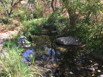
Before there were any Hinkle’s or Folsom’s there were Native Americans. They left an indelible mark of their long presence in the area with numerous grinding or milling holes in exposed granite slabs. Because the Hinkle Creek Nature Trail has not had recent maintenance as of 2019, the Native American grinding holes may be difficult to spot. I was able to expose a set of the bedrock mortar holes that I found.

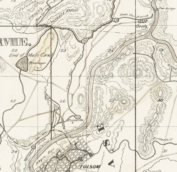
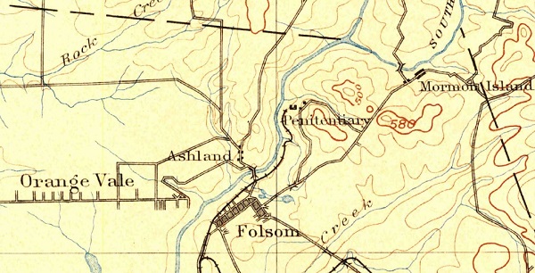
Hinkle Creek is a deep ravine that opens up onto the American River from the north. The watershed for the creek is pretty small so before the advent of water ditches and suburban homes, the creek would be dry during the summer. The depth of the ravine along with the trees would make this a nice cool summer location that offered some protection from the elements during the winter.
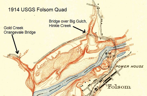
Of course, any Native American residents in the area would have been quickly dislocated with the immigration of gold miners in 1849. As prospectors from all over the world descended on the American River searching for a location rich in placer gold, the ravine that opened up onto the American River, across from Negro Bar on the south side, was called Big Gulch. The name stuck and was noted on Doolittle’s map of gold fields in 1868.1
Gold Mining In Hinkle Creek
One miner who prospected at Big Gulch was B. N. Bugbey. In the spring of 1850 he mined at Big Gulch and then switched to the south side of the river to Negro Bar. He discussed his time mining at Big Gulch as a witness in the 1881 debris trial Sacramento vs. Gold Run Ditch and Mining Company.2 The placer gold at the interface of Big Gulch and the river was quickly exhausted and miners went further up the ravine to work dry diggings.3
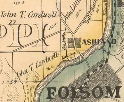
By 1857 a collection of houses and barns dotted the rolling landscape directly to the east of Big Gulch and was called Ashland by 1860.4 In the mid-1850s the North Fork Ditch, which ran along the west side of the North Fork of the American River, extended delivery of water into the Big Gulch area for mining and agricultural purposes.5
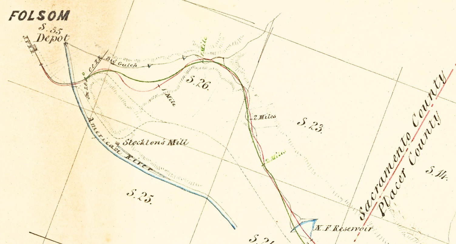
After the completion of the Sacramento Valley Railroad (SVRR) to Folsom a new railroad line called the California Central Railroad (CCRR) started construction from Folsom up to Lincoln. The CCRR built a large wooden trestle bridge over the American River just below and to the east of Ashland. They built another bridge over Big Gulch and cut a railroad bed on the south face of the bluff which is today’s Greenback Lane.
When Theodore Judah was designing the SVRR he was always looking for an economical way to get to the mining communities in Auburn and Grass Valley. The goal of the CCRR was to get to Marysville and then service the mines via along the Yuba and Feather Rivers. Merchants and miners in Auburn still wanted a rail line. In 1860 they were able to secure partial funding for a railroad from Ashland up to Auburn. This was called the Sacramento, Placer, and Nevada Railroad (SPNRR).
Railroad Line Up Hinkle Creek
Work on the SPNRR commenced in 1860 in Ashland and followed up the Big Gulch ravine. The SPNRR would wind its way up the low lying foothills through today’s Folsom Lake and up alongside Folsom-Auburn Road. It would stop far short of its destination in 1862 as funding dried up and the Central Pacific Railroad was on course to service Auburn from Sacramento.
Isaac Hinkle Arrives In Ashland
Isaac Hinkle was 25 years old and working on his father’s farm in Indiana in 1880.6 His older brother Amos had left the farm for California and Isaac decided to follow him in 1881. By 1882 Isaac was a registered voter in Sacramento County’s Mississippi Township.7 In 1885 Isaac married Jessie Brown and would have a long marriage with Jessie for the next 48 years.8
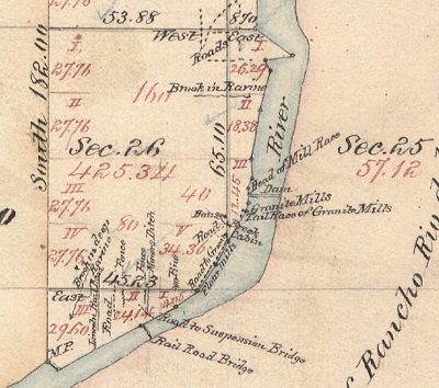
Also in 1885 Isaac Hinkle would make his first land purchase. He bought land in the town of Ashland from John Cardwell who was a large owner of in the area for $850.9 Even though the land was within the Public Land Survey System of Townships and Ranges, the deed refers to original metes and bounds description before the 1865 official survey map.
In the Town of Ashland, Township of Mississippi commencing at a point on the picket fence of Main Street Ashland, midway between frame buildings of Mr. Latham and Hicks, running North 78 degrees East 16 chains and 19 links to a black oak tree. Thence North 12 degrees West 3 chains and 10 links to a hill of stones in mining claim of George Little. Thence south 78 degrees West 16 chains and 19 links to a corner of the picket fence on Main Street. Thence South 10 degrees East 3 chains and 10 links to the place of the beginning.
Also the following in said town, beginning at corner of J. Lawton’s land on the West side of Public road running through the town of Ashland, running thence along said road North ½ degree West 4 chains to the corner of Mr. (Howes) fence, then along Mr. (Howes) fence West 77 chains to corner of J. J. Cardwell’s fence, thence along Cardwell’s fence South 2.47 chains S. E. corner of stable, thence west 1.26 chains to S. W. corner of stable, thence South 1.70 chains to N. W. corner of Lawton’s lot, thence along Lawton’s fence East 2.2 chains to place of beginning, containing .64 acre.
Also the following in said town of Ashland: Commencing at the intersection of McKean’s East fence with John F. Howes South fence, West of the Rocklin Road. Thence running South 150 feet along said McKean’ East fence. Thence West 160 feet. Thence North 160 feet to said Howe’s South fence. Thence East along said fence to the place of the beginning.
Being same land conveyed to Hugh McKean by George Little and wife recorded in book 66 of deeds, page 465 Sacramento County.10
Sacramento County had produced a map in 1885 showing some of the landowners of property in the county. George Little is listed as the property owner of land west of the town of Ashland. A subsequent deed in 1920 when Isaac Hinkle sold the property to the gentlemen Vincent, Wright, and Galloway it states the area was 8 acres11, but still refers to the original metes and bounds description of the property. Hinkle sold the property for $3,000.
What is not entirely clear is how much of the property encompassed the Big Gulch drainage area. It does not seem that Isaac Hinkle was ever the primary owner of much the land we call Hinkle Creek today. However, he would become known as a large land owner and have influence over the North Fork Ditch that delivered water into Big Gulch.
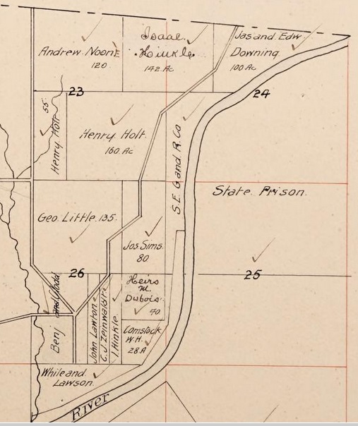
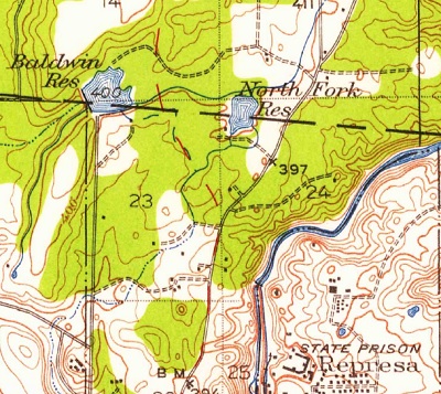
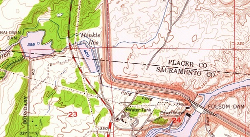
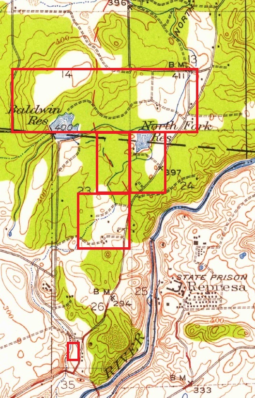
By 1896 Isaac and Jessie had settled in the new Orange Vale Colony and he was employed by the North Fork Ditch as a water agent.12 In 1899 Isaac bought 160 acres. He acquired the East half of the Northeast quarter of section 23 and the West half of the Northwest quarter of section 24 in Township 10 North, Range 7 East for $1200.13 This property was 2 miles north of Ashland but strategically important for the North Fork Ditch. In 1902 he sold 15.4 acres of this property to the North Fork Ditch for a new reservoir.14 One of the conditions of the sale was that the land always be used for a reservoir. If the reservoir was ever abandoned, title would revert back to Isaac Hinkle. The North Fork Ditch reservoir now lies under the right wing dam of Folsom Dam. A new reservoir built for holding treated drinking water for the San Juan Water District was named after Isaac Hinkle.
The North Fork Ditch was a 22 mile long water canal that began on the North Fork of the American River and had its primary terminus in this location of the new reservoir. The North Fork Ditch had built Baldwin Dam and the Penstock Reservoir, north of Oak Avenue, to service the Orange Vale Colony and the growing communities of Fair Oaks and Citrus Heights. Because the North Fork Ditch delivery was primary through gravity flow, it was important to be able to control water flow for distribution and also to settle the mud out of the water.
Later in 1902 Isaac Hinkle would buy another 160 of land from Henry Hols for $10. This land was the Southeast quarter of section 23 in Township 10 North, Range 7 East.15 In 1907 Hinkle was made Superintendent of the North Fork Ditch Company.16 In 1908 Isaac would sell 10 acres of his property to Frank Spurgeon in the SE ¼ of section 23.17 A map of most of Isaac Hinkle’s property purchases is at the end of the post.
Perhaps on the relative success of the Orange Vale Colony, Isaac Hinkle became involve in the Inwood Colony. Like Orangevale, the Inwood Colony lots had access to water from the Slate Bar branch of the North Fork Ditch that ran down to Ashland. Isaac sold lots 4 and 5 in block 2, subdivision 1, of Inwood Colony to Emil Miller for $10.18 Part of Inwood Road today, west of Folsom-Auburn Road, is the remnant of the SPNRR and Inwood Colony.
The nearly 50 year old railroad bed of the SPNRR was still present through the area. And while the railroad was long gone, its reference point was not. It was a defining boundary feature in many of the deeds for the Inwood Colony.
All that portion of lots Number 4 and 5 in Block 2 of Subdivision 1 of the said Inwood Colony lying east of the old roadbed of the railroad running from Folsom, California, to Auburn Station, Placer County, California, as shown on map of said Inwood Colony on file in the office of the County Recorder of the County of Sacramento, State of California.19
Isaac Hinkle would buy another 480 acres north in section 13 and 14 in 1920.20 While tending to his North Fork Ditch Superintendent duties he was also farmer and rancher growing primary fruit trees on his property.21 He was part owner of Hinkle and Earl Fruit Company on land next to the American River across from the Folsom State Prison. This land was planted primarily in olive orchards.
Isaac Hinkle was active as a mortgage lender with his partner H. Clemensen who was also the Notary of Public on several of his land transactions. In 1927 Hinkle and Clemensen released a Deed of Trust back to Raymond Broder for his ranch land east of Folsom in the Natoma Township.22 Hinkle and Clemensen also lent money to the Orangevale Fruit Growers Exchange which they paid off in 1926.23
Hinkle’s Reservoir
Isaac Hinkle’s quiet demeanor and experience with property led him to be one of the original founders of the Bank of Folsom in 1910. He was also involved in the Methodist Episcopal Church, Rebekah Lodge No. 166, at Folsom, and the Folsom Encampment No. 24, I. O. O. F. Isaac and Jessie had three children. Only Henry survived into adulthood. 24 He retired from the North Fork Ditch in 1931.25 Isaac Hinkle died on June 1, 1933 and Jessie died in 1940. Both are buried in the Lakeside Memorial Cemetery in Folsom California.
I think Isaac Hinkle would be honored to have the Big Gulch creek and ravine named after him. From all accounts he was instrumental in the maintenance and expansion of the North Fork Ditch which delivered water into the area. The North Fork Ditch Company and its successor the San Juan Water District have been an important foundation for suburban growth in northeast Sacramento County. Without water the communities of Orangevale, Citrus Heights and Fair Oaks would have had their growth severely restricted in the early years of their formation.
Some would argue that Isaac Hinkle helped contribute to suburban sprawl with the availability of inexpensive water from the North Fork of the American River. Of course, during his tenure the focus was really on small family farms and ranches. Either way, a nature trail and center dedicated to preserving the history of Native Americans, early gold mining, water ditches, and a railroad line is eminently worthy of our community’s support. The Save Hinkle Creek organization is working to protect this historically rich resource. I believe Isaac Hinkle would lend his time and expertise to also preserve this little slice of property that is so historically important.
Click the thumbnail image to enlarge.
The research on Isaac Hinkle is not meant to be a comprehensive biography of him, his family, or land purchases. I welcome any other information that may fill in some holes or correct any assumptions that I may have made.
End Notes
- California Gold Camps, Erwin G. Gudde, 1975
- Sacramento v Gold Run Ditch, California State Archives microfilm MF2:9 (46) Roll 4, Pages 4558 – 4599
- An Illustrated History of Sacramento County, California, Winfield J. Davis, 1890
- An Illustrated History of Sacramento County, California, Winfield J. Davis, 1890
- An Illustrated History of Sacramento County, California, Winfield J. Davis, 1890
- 1880 Federal Census
- California Voter Registrations 1866 – 1898
- Sacramento County Marriage Index 1885
- Sacramento County Deed document 18850905, Page 136 and document 18850924, page 182.
- Sacramento County Deed document 18850905, Page 136 and document 18850924, page 182.
- Sacramento County Deed document 19200715, page 409.
- Sacramento County Voter Registration 1896
- Sacramento County Deed document 18990227, page 157
- Sacramento County Deed document 19020805, page 538
- Sacramento County Deed document 19020851, page 560
- U.S. Cities Directory, Sacramento County 1907.
- Sacramento County Deed document 19080324, page 201
- Sacramento County Deed document 19081208, page 646
- Sacramento County Deed document 19081208, page 646
- Sacramento County Deed document 19200326, page 238
- Sacramento County Deed document 19331024, page 436
- Sacramento County Deed document 19300416, page 89
- Sacramento County Deed document 19260205, page 138
- History of Sacramento County, California, By William L. Willis, 1913
- 25 1932 California Voter Registration, Sacramento County
