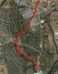
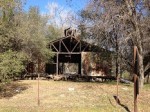
Sacramento Placer and Nevada railroad as it passed through Folsom, Granite Bay and Loomis
It was perhaps the first publicly finance railroad in California. Unfortunately, the Sacramento, Placer and Nevada Railroad was cut short by an even larger publicly financed railroad know as the Central Pacific. (Click on the photos to enlarge, full gallery of images at end of post.)
Iron horse for commerce
As soon as the Sacramento Valley Railroad (SVRR) was completed in 1856, Placer and Nevada county business interests serving the booming gold mines starting calling for an extension of the line from Folsom up to Auburn and into Grass Valley and Nevada City. Chief Engineer of the California Central Railroad (CCRR), Theodore Judah, surveyed a route from Auburn down Secret Ravine to intersect with the CCRR in Griders Junction or modern day Roseville. Known as the Auburn Branch Railroad it was never built and Theodore Judah later moved on to advocate full time for the development of a transcontinental railroad.
Surveying a railroad grade
Regardless of the obstacles presented by Auburn Branch Railroad because of the numerous ravines to be crossed and bridges to be built, local residents organized the Sacramento Placer and Nevada Railroad Company in 1859. A subsequent survey was undertaken and published in 1860. Instead of intersecting with the CCRR in Roseville, the new line surveyed by Sherman Day, turned south at Newcastle following the contours of Secret Ravine and crossing over into Miner’s Ravine. The final destination was just north of Folsom at Ashland on the north side of the American River.

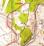
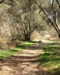
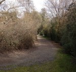
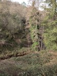
12 Possible Sacramento, Placer and Nevada railroad grade along Miners Ravine Creek.
The new route for the SPN RR was broken up into two divisions. The upper division from Auburn to Secret Ravine was the more costly and difficult to build. By contrast, the lower division was free of major ravine crossings, partially followed an established stage coach route from Sacramento to Auburn and was far less expensive to construct. Day estimated that the lower 13 miles of the SPN RR would cost $130,000 while the remaining 4 miles or upper division would be $386,000 because of the numerous bridges that need to be constructed.
In Sherman Day’s report on the rail route he states,
As the second division of the road, about thirteen miles nearest Folsom, costs so much less in proportion than the upper, it may be thought good policy to enter at once upon the construction of the lower division, thus giving impetus to the work and providing for transportation of the materials for the heavy bridging on the upper portion.1
Public finance option
Pretty excited that a route had been finalized for the SPN RR, Auburn residents were able to convince the California State Legislature to pass a bill allowing the city to create a ballot proposition that would allow the city to invest in the railroad. The subsequent ballot measure passed making the SPN RR possibly the first publicly subsidized railroad with a $50,000 investment.
The city of Auburn’s investment was not nearly enough, but recognizing the success of the first vote, several other propositions were authorized through out Placer County and other districts. They all failed to pass. The SPN RR organizers were able to go out and sell an additional $60,000 in shares of stock from Auburn, Sacramento and San Francisco by 1861.
Brief construction and operation

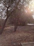
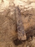
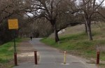
8 Both North Fork Ditch and SPN RR would have headed toward today’s Dyke 5 of Folsom dam. This could be the old railroad grade.
Construction was started in the summer of 1861 and completed to a point called Auburn Station, 13 miles north of Folsom, in September of 1862. That was also the year that Congress authorized the even larger publicly funded transcontinental railroad project. When the western half of the transcontinental railroad, the Central Pacific Railroad, reached Newcastle in 1864, there was very little need for the SPN RR.
Discovering the original route
It is one thing to map out a route of a railroad, but it was an entirely different matter to actually grade the road bed and construct the line. Consequently, the finished rail line doesn’t always follow exactly what may have been marked down on the survey map.
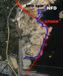
North Fork Ditch
By the time work was started on the SPN RR in 1861, the North Fork Ditch (NFD) had been completed in 1856. While the rail line would only parallel the ditch for a few miles, the railroad construction would need to consider where it would cross the ditch and not get so close as to undermine the earthen berms that made up the canal walls.
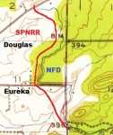
1941 USGS map showing NFD and railroad approximate route.
A second variable is the geology through out the area. Tremendously large domes of granite can lie right beneath the surface of the soil. It would not be unexpected to run into a scenario where a cut and fill operation was to be undertaken only to find a mass of granite where the crew wanted to cut. It is far easier to re-route a road around a granite boulder than to try and reduce the granite.
The SPN RR started at Ashland which was a small depot on the north side of the American River across from the terminus of the SVRR in Folsom. The California Central RR had built a bridge over the American River from Folsom on the south side and ran next to the Ashland Depot on its way to Grinders Junction (Roseville) and Lincoln.
Railroad grade, modern roads and crossings
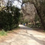
From Ashland, essentially the intersection of Greenback Lane and Auburn Folsom Rd., the SPN RR traveled northward along Big Gulch which was one of several deep and narrow ravines in the area. This path would turn into Oak Ave., where the route it eventually transforms in bicycle path up to Oak Avenue Parkway. After Crossing Oak Avenue Parkway, the most visible portion is now the private dirt road portion of Inwood Rd.
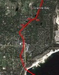
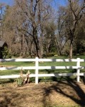
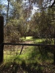
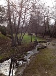
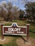
The SPN RR route continued along a little creek in the area most likely avoiding a wetlands area now known at Egloff Park. It would continue northwest on Lakeside Way through the spot where the commemorative plaque is located. At this point it crosses Folsom Dam Rd. and Auburn Folsom Dam heading toward what used to be Beal’s Bar on the North Fork of the American River.

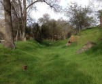
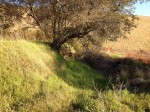
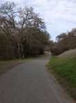
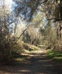
4 Still visible is SPNRR cut at Cascade Falls and Oak Avenue Parkway
Crossing under what today is the western wing dam of Folsom Lake, the SPN RR would have come upon the reservoir for the North Fork Ditch. It ran next to the ditch turning to the west near where the NFD had a spur ditch traveling north as well. As the route passed under todays Dyke 5 of Folsom Dam traveling north to cross Eureka and Douglas Roads, old descriptions mention that the line passes by Rose Spring. Other than an extension to the North Fork Ditch called the Rose Spring Ditch, I have never been able to locate any such spring in the Granite Bay area. My hunch is that Rose Spring may have along present day Linda Creek as drainage from the surrounding hills bubbled to the surface in the creek bed.
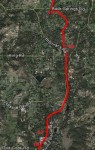
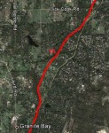
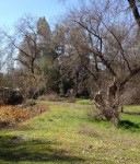
The NFD, which the SPN RR was running next to, ended at around Sturm Lane and Joe Rogers Rd., the rail line continued north and northwest following the flood plain of Miner’s Ravine Creek. It would continue to follow the creeks relatively flat flood which is also shadowed by Auburn Folsom Road. The SPN RR would cross present day Auburn Folsom Rd. in several places while traveling through Hidden Valley Lakes Estates
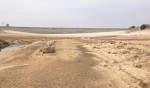
The line wound its way along the hills on the path of least resistance through what is today American River Canyon and north Folsom subdivisions. It approached Beal’s Bar from the southwest where it began to run parallel to the North Fork Ditch. Today, all of this area is entirely covered by Folsom Lake but remnants of the ditch can be seen at low water level.
Through Granite Bay and Loomis

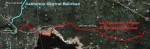
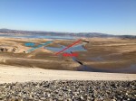
Aerial view of railroad and north fork ditch in Folsom Lake.
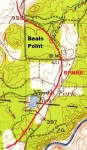
It followed the NFD north just south of Miner’s Ravine Creek where the ditch terminated. The SPN RR then travelled along the flood plain of Miner’s Ravine in a northwesterly direction to just pass Dick Cook Road. At this point, the SPN RR continued north while the creek went northwest. Just as the topography starts to really increase in slope before entering Secret Ravine, the SPN RR stopped just south of Rock Spring Road.

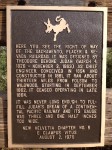
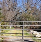
Commemorative Plaque noting that the Sacramento Placer Nevada Railroad crossed this point on Lakeside Drive in Loomis. Did Theodor Judah really lay out the route or was it Sherman Day?
For a brief period of the history, the Granite Bay area had a railroad even if it wasn’t high speed rail. If the rail line went through your property and you want it documented, let me know and we can get some pictures and put it on the map.
Disclaimers, I’m not a historian
The route of the Sacramento Placer and Nevada Railroad that I have created was recreated by various maps at the California Railroad History Museum, history texts, site visits and Google aerial map images. I don’t claim this to be a perfect recreation, but an approximation. My source material may have errors as well as my own work.
Theodore Judah or Sherman Day
Interestingly, the E Clampus Vitus commemorative plaque seems to possibly give Theodore Judah more credit for the line than he maybe due. He has been attributed with the design of the Auburn Branch railroad and no doubt probably looked the SPN as a possible route also.
Since the California Central Railroad was being considered, it would only make sense that Judah tried to connect the SPN with CCRR with the Auburn Branch line. Supposedly, the Placer Herald published on March 31, 1860, the survey work done by Sherman Day who was hired by the SPN RR to design a route from Auburn to Folsom.
Special Thanks to Phoebe Astill Curator at the Roseville Historical Society at the Carnegie Museum for all her work and access to their library.
For more great pictures and additional history check out Foothill Rails
1. History of Placer County California, Thompson & West 1882, Oakland, CA. Reprint


Click to enlarge thumbnails, numbers preceding pictures correspond to numbers on aerial maps above and relative position of where the photo was taken.