

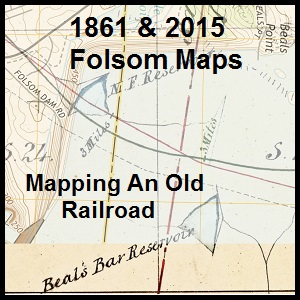
Comparing the original 1861 Sacramento, Placer, and Nevada Railroad map to current USGS topographical as the line passed through Folsom Lake, Granite Bay, along Miners Ravine into Loomis.
It was a stroke of luck that I stumbled upon the original 1861 map of the Sacramento, Placer & Nevada Railroad (SPNRR) map in the California State Archives. With a digitized version of the original map, I could then compare the constructed rail line to modern roads and Folsom Lake shown on 20th century maps. While the 1861 and modern-day maps don’t align perfectly, there are enough similarities to confirm suspicions of the route through the Folsom and Granite Bay areas. Overlay maps at end of post.
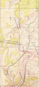
The first 1861 SPNRR map copy I got was from the California State Railroad Museum. It was a black and white reproduction. Normally a black and white map is good enough, except this map had two colored lines on it. The original location was in green and the as-built location was in red. While the two lines were fairly distinct, sometimes separated by a mile in distance, when they grew close together, it was difficult to know which black line for the actual railroad. The original 1861 map from the California State Archives clearly shows the red and green rail lines in color! (See: History of the Sacramento, Placer, Nevada Railroad post)
Sacramento, Placer, & Nevada Railroad 1861 Map
Construction was started in the summer of 1861 and completed to a point called Auburn Station, 13 miles north of Folsom, in September of 1862. That was also the year that Congress authorized the even larger publicly funded transcontinental railroad project. When the western half of the transcontinental railroad, the Central Pacific Railroad, reached Newcastle in 1864, there was very little need for the SPNRR.
Earlier Mapping Efforts
I was not the first to reconstruct the SPNRR on current topographical maps. Chris Graves and Bud Uzes plotted the railroad on USGS quadrangle maps back in 2005. Their work probably recreates the line closer to the original because they used the actual table of curves and tangents data from the map. As any contractor will tell you, there is the blue print of how to build the project and then there is the project as it was built. In other words, the route on the map doesn’t always conform to the reality out in the field.
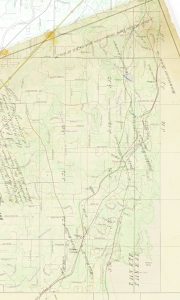
Comparing 1861 to 2015 Maps
To add even more uncertainty and error of comparing a 1861 map to 21st century streets are the changes the United States Geological Service topographic maps. The standard for notating position on maps through most of the 20th century was the Range and Township grid system. Each grid section was one square mile. It was further broken up into 36 smaller sections. Consequently, you can usually line up the section grid lines on maps and know you are referencing the same area.
The latest Range and Township USGS topographical maps of the Folsom to Auburn area were produced in the 1950s. Even those maps were more accurate than those produced in the 1860s, especially when it came to the topographical features such as hills and streams. 21st century USGS maps don’t use the Range and Township grid system but the more accurate longitude and latitude coordinates. While that can present some challenges to comparing maps, I was surprised how closely the 1861 SPNRR map comported to the USGS topo maps of the 1950s and 2015.
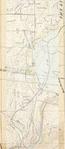
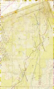
Because the USGS topographical maps from the 1950s were broken up into two quadrangle regions (Folsom and Auburn), I also split the 1861 SPNRR, which was called the 1st or Lower Division of the SPNRR, map into two sections for comparison. Consequently, I created a merged map for what I call the Folsom section and one for the northern section. The Folsom section covers from Ashland Station, just north of the American River, up to the SPNRR intersection with Miners Ravine Creek. The northern section (USGS Auburn 1953 and Rocklin 2015) generally covers from Miners Ravine up to Wildwood station or slightly north of King Road in Placer County.
While I could get the Range and Township grid lines to closely match, I could never get the county line between Sacramento and Placer match up. I’m fairly certain that the Sacramento-Placer County line is wrong on the 1861 map by approximately 1/8 of a mile north. I did use other land and man-made features to coordinate the overlays of the maps. We know, for instance, that the rail line followed Big Gulch in Folsom, ran very close to the North Fork Ditch through the Folsom Lake area, and paralleled Miners Ravine Creek for a short section. I also used the Mammoth Reservoir, a small pond that the Boardman Canal flows into north of Horseshoe Bar Road, as map marker.
When comparing the original 1861 map with current maps, follow the red line from 1861 that was the final grade for the railroad. From Ashland Station (Corner of Auburn – Folsom and Greenback) the SPNRR followed Big Gulch ravine, (Oak Avenue). It crossed over Oak Avenue Parkway towards the river. Part of Inwood Road was the original grade. It entered todays Folsom Lake area under the west wing dam where the North Fork Ditch had one of their reservoirs. Travelling north, around today’s Beals Point, the line turned west toward Rose Springs and Dyke 5.
For unknown reasons, the original route and the final route split apart. The original railroad grade looks as if it was going to follow the North Fork Ditch to the east of Beals Point. This would have taken the railroad through today’s Granite Bay Beach Park and traveled along Boulder Road through Los Lagos which was also a stage coach route. As the builders of the North Fork Ditch learned from building the water canal, the original east-side route would have encountered significant granite bedrock. The North Fork Ditch, in order to maintain its gradual slope, had to cut through large granite out-croppings for the water ditch.
By heading west at Rose Springs up to Miners Ravine Creek, the SPNRR would have been grading over more top soil and less granite boulders. The line was still following a branch of the North Fork Ditch called the Allen Ditch as it headed up to Miners Ravine Creek. The SPNRR would continue to follow Miners Ravine Creek and portions of today’s Auburn – Folsom Road where it finally terminated north of King Road in Loomis. The upper division of the SPNRR was never built. The California Central Railroad was being built from Sacramento and had reached the Roseville vicinity by 1864. With the eventual arrival of the CCRR in Auburn, funded in large part by the federal government, the SPNRR could not compete and was abandon.
Our modern mode of development usually erases most vestiges of history. We know the Maidu Native Americans inhabited the Folsom, Granite Bay, and Loomis areas because we are able to locate their numerous acorn grinding holes on top of granite boulders. The concrete remnants of the North Fork Ditch remind us of the large scale water projects built in the region for gold mining. Historical maps, such as the SPNRR map, tell us that other massive transportation projects were undertaken before automobiles ruled our lives. You can probably even find faint outlines of the old railroad grade as it traveled from Folsom to Loomis for a brief period of time.
Map Overlays
Sections of the SPNRR map to be layered over current USGS topographical maps were rotated to match the north-south orientation of the new quadrangle maps. This undoubtedly introduced some error in matching up the maps. However, I did not stretch or compress map heights or widths to create a best fit. I’m sure someone with more imaging software knowledge (I used Adobe Photoshop Elements) could create better reproduction overlays.
Click the image to enlarge.


View full 1861 Sacramento, Placer, and Nevada Railroad Map