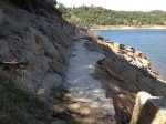
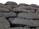
Volcanic mud flow is particularly hard to wash away, Rattlesnake Bar.
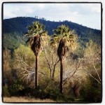
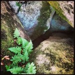
The air was heavy with the scent of what smelled like clove oil. It wasn’t some exotic spice but the indigenous poison oak plants that were in spring bloom all along the Pioneer Express Trail. As I hiked along the north fork of the American River I wondered if the stands of poison oak and their scent were this abundant in 1850.
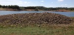
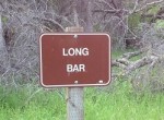
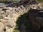
Glimpse of old Bars
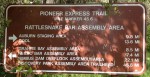
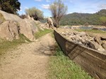
This Pioneer Express Trail is not the original path the early miners necessarily traversed on their way to prospect on the many river bars. The trail has been moved higher in elevation so it is usable when Folsom lake is at capacity. Even though Folsom Lake covers most of the old mining bars, when the lake is only 3/4 full, you can still see some of the mining tailings left on the upper portion of Folsom. [Click on thumbnail images to expand, for more photos along Pioneer Express trail see Rattlesnake Bar to Birdsall Dam Hike
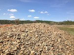
Dance floor next to the bridge

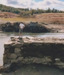
My 12 year old son standing on the Gwynn’s or Rattlesnake Bar bridge abutment in 2009.
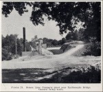
Rattlesnake bar is a particularly good place to walk, hike, run or bike around mining history. At one time there was a thriving little village of homes, shops and a bridge connecting Placer county to El Dorado county on the other side. A picture at the Placer County Gold Mining Museum even shows a small hydraulic mining monitor shooting water on a hillside at the Rattlesnake bar. From the large 1887 map of Placer County hanging in the court house, the suspension bridge at Rattlesnake Bar was known as Gwynn’s Bridge. I have seen an old photo of the Rattlesnake community that showed a dance floor next to the suspension. It must have been a lively place.
Hydraulic mining

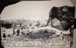
Placer County Museum of Mining photo of hydraulic mining at Rattlesnake Bar
While we normally think of the big hydraulic operations at places like Malakoff Diggins, large monitors aiming 4″ of water at a hillside 300′ away, many of the rivers bars would have been below the North Fork Ditch (NFD) allowing for moderate water pressure. The NFD was at 490′ elevation at Birdsall dam and slowly descended to 410′ elevation around Beals point. At Rattlesnake Bar the NFD was at 477′ and the rivers edge at 360′. If they used a hydraulic monitor at about the 400′ elevation line, that would have given the miners about 30 pounds of water pressure (1 foot = .43 pounds per square inch, 77 x .43 = 33.11 psi).
Ancient river bottoms
30 psi is not a huge amount of water pressure, but it was enough to wash away the river bluff that was ancient river bed. Even today

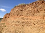
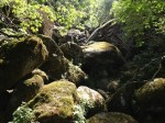
Layers of ancient river bed at Rattlesnake Bar possibly containing gold.
you can see the different layers of strata laid down from river floods and volcanic mud flows down the canyon in the exposed bluff. Just as the placer gold could be found in the river above the bedrock, it could also be found in old river bottom layers. That was the primary purpose of the NFD; to supply water to the miners. Gold possibly retain in ancient river bottoms enticed miners to dig mines on higher ground, without water, like in Granite Bay.
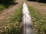
Water ditch line
It is hard to gauge how much of the landscape has changed from the early mining days. The river bed dredging, torrents of mud from upstream hydraulic operations, raging floods and finally the filling of Folsom lake have all altered the river canyon landscape. One line and remnant of the past is the carcass of the North Fork Ditch. Completed in 1856 it traces an elevation line above the river until it finally disappears into the water of Folsom lake.
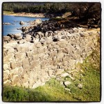
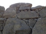
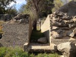
Romanesque built Viaduct
The Pioneer Express Trail is generally above the NFD, but there are plenty of place where you can hike down and walk the ditch line. South of Horseshoe bar you will come upon what is referred to as the NFD viaduct. This is an impressive structure built to conduct the water over a small ravine. Easily 15 feet tall and 40 feet in length, large granite blocks were carefully stacked to create what looks like a dam.

Rock over wood
Because the NFD winds around the viaduct, I have to assume that the viaduct was built before the concrete lining of the ditch in the 1910’s. Often times the North Fork Ditch company would build flumes across a creek or particularly long ravine to shorten the distance. Many of these wooden flumes would be washed away during floods, but not this viaduct.
Viaduct height is at least 15′ tall.
Why not more viaducts?
It’s apparent that the builders of the NFD would use local rock to build up and support the earthen berms on the river side of the ditch. The rock used closer to Auburn is very different than the granite used as the ditch approached Folsom. It’s possible that in this particular location these granite blocks were readily available to construct the viaduct. Otherwise, I would expect to see more construction of stone flumes and viaducts along the ditch route, but I don’t.
Oral history of the past
While I don’t know exactly when the viaduct was constructed, it has stood for decades and many miners and travelers along the original Pioneer Express Trail must have marveled at it as I did. But the miners were not there to marvel but to prospect, pan and mine for gold. An oral history published in the History of Placer and Nevada Counties in 1924 gives some perspective to the small mining communities along the North Fork of the American River. Maurice Andrew Kelly (Identified as mine owner in the Rattlesnake Bar hydraulic mining photo) was born in 1855 on Manhattan Bar and recounted his memories growing up and living at Rattlesnake Bar. Memories and oral histories can be distorted with time. With that in mind, here are few bits of Mr. Kelly’s recollections about the bars and mining camps on the river from south to north.
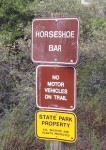
- Beal’s Bar was a rich bar with lively camp life that rivaled Horseshoe and Rattlesnake Bars.
NFD turn out to supply water to a mining company, near Dotons and Granite Bars.
- Carlton Bar was a high bar where hydraulic mining was employed.
- Doton’s Bar was a high bar also and produced much gold.
- Kehoe Bar was a deep gorge in the river. There was a suspended flume that carried mining water. The cables were later used for the suspension bridge at Rattlesnake bar.
- Horsebar was a rich and extensive bar with a large trading station, saloons, livery stables, hotels, gambling-houses and dry goods store. Supposedly, there was also a theater that stage plays and hosted other entertainers such as Lotta Crabtree, Lee Brothers Circus and prize fighter John Morrissey.
- Whiskey Bar had the first suspension bridge over the river. When it washed out, the cables were hauled up river to be used by William Gwynn to build the Rattlesnake Bar suspension bridge that connected to Goose Flat Bar. Whiskey Bar also had a sawmill that cut the logs to make the wooden flumes.
- The Bars from Whiskey to Rattlesnake were worked with a dredge for several years by the Gaylord Company.
- Rattlesnake Bar was a well rounded community with black smith, butcher, hotels, theater and school house. A stage coach ran daily from Rattlesnake to Auburn. Most of Rattlesnake Bar proper burned down in 1864 and was never rebuilt. Pay dirt for the miner was 20′ to 60′ below grade down at the bedrock level.
- Mr. Kelly notes that each town or mining camp furnished its own coffins.
- Kentucky Bar was worked by a company of 25 men. Each miner was had his pay weighed out in gold every week. Kentucky Bar was a spot where the NFD ditch was flumed across a long ravine. [This would be modern day Mormon Ravine where the PG&E Newcastle Power Plant is located]
- Willow Bar and Patrick’s Bar had a ferry connecting them and the toll was a pinch of gold dust.
- Poverty Bar was covered by the last dam for the North Fork Ditch called the Birdsall Dam.
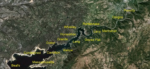
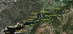
Some of the Bars and approximate locations along the north fork of the American river.

Placer mining quickly washed out
Mr. Kelly went through a litany of Bars, large and small, and the names of miners who worked them and where they relocated after the gold ran out. Most of the independent mining activity seemed to happen between 1850 and 1864. Larger operations continued on into the 19th century with dredging. It is unknown what impact the tailings from the hydraulic mines up river effected these smaller placer mining operations down below.
Hike through history
Unless Folsom lake is really low, you’ll never get to close too spot where these bars were first mined along the river. However, walking along the trails, seeing the viaduct, oak trees, and granite out cropping’s gives you a pretty good sense of the landscape these miners encountered.