
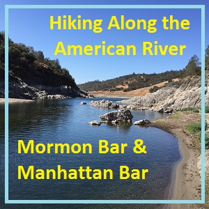
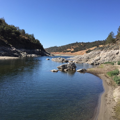
Hiking along the North Fork of the American River at low Folsom Lake water levels above Rattlesnake Bar.
With Folsom Lake water levels low in the autumn of 2016, I decided to hike from Rattlesnake Bar up the North Fork of the American River to see if I could catch glimpses of gold rush era history. The terrain was far more difficult than I imagine. While I know the river canyon has change since the gold rush of 1849, I was surprised at just how arduous the hiking along this stretch of the river must have been for the gold miners. Picture gallery and video at end of post.
Hiking up the North Fork of the American River
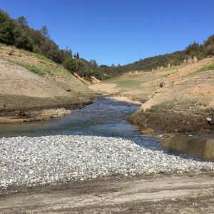
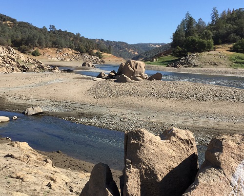
On October 1, the day of my hike, Folsom Lake was at 31% capacity and at 388 feet of elevation. That is 38 feet higher than the lowest level reached in December of 2015 during the big drought. In 2015, at approximately the same time of year, the river was flowing around Rattlesnake Bar and hit the calm waters of Folsom Lake south of Horseshoe Bar. On my October hike, the river flowed into the reservoir just south of Mormon’s Bar.
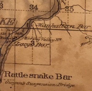
1884 Placer County map showing Lacy’s and Manhattan Bar above Rattlesnake Bar.
Mormon Bar or Lacy’s Bar
Mormon’s Bar was also identified at Lacy’s Bar on old Maps. It is at the mouth of Mormon Ravine which has a seasonal creek. However, water flows down the latter part of Mormon Ravine from the Main South Canal which also feeds water into the PG&E Newcastle Power Plant. A tremendous amount of water can flow through the penstock, turning the hydroelectric generators, when the power plant is operating. The water from the ravine was flowing steadily when I crossed it on my hike.
The confluence of the creek from Mormon Ravine and the North Fork of the American was the scene of a conflict between white miners and immigrant Chinese miners during the early gold rush days.
1852 Sacramento Daily Union May 5th, 1852
Driving out Chinese
Mormon Bar, North Fork Am. River, Sunday, May 2d, 1852. Messrs. Editors : — The excitement in regard to the Chinese is rapidly extending along the banks of the North Fork of the American River, and daily expulsions are taking place. This morning some sixty Americans ranged down the River some four miles, driving off two hundred, quietly removing their tents, strictly respecting their persons and property (except in one instance., when a Celestial seemed inclined to be ” obstreperous,” his cradle was thrown into the river. The same company intend to proceed “en masse” to Horseshoe Bar this afternoon to concert measures with the miners there to “start” some four hundred located at that place. A band of music is engaged to accompany the expedition. The feeling is strong, and anything but evanescent, that self-protection as a first law of nature, must and shall be enforced. Would it not be well for your city government to take some action on the subject, for you will certainly have a flood of them from above and below you soon. There is but one opinion among the miners in regard to the proposed monopolies and importation of Chinese into the mines, and nearly all of the eighty or ninety thousand American miners are fully determined to submit no longer to have the public lands robbed of their only treasure. Yours in haste, as I accompany the expedition down the River. Chadbourne.
Looking up Mormon Ravine from Mormon Bar.
A much easier hike is the Pioneer Express Trail that parallels the river above the high water mark of Folsom Lake. However, I wanted to hike along the river just like the gold miners of the 19th century.
What I found was an strenuous hike over cobble rocks and over bedrock cliffs along the water’s edge. North of the Rattlesnake boat ramp the hillside is very steep. The river canyon opens up at Mormon Ravine where I had to wade through the water flowing out of the ravine. After making the hike, I had a new appreciation for a similar hike reported in 1858 recounted by a gentleman that had traveled the river route reporting on the different mining operations at the time.
1858 Daily Alta California, Volume 10, Number 252, 13 September 1858 — MINING ITEMS.
Mining Bars North Fork American
A correspondent of the Sacramento Union, writing from Auburn, September 9th, gives the following notice of mining operations in that vicinity :
Having a little leisure time yesterday, I took a stroll down the river to witness some of the mining operations that are carried on near this place. The first claim I came to was that of Harper & Co., on Little Rattlesnake Bar, one mile from town. This claim belongs to a company of five, and was located in 1850, and has been worked every year since with one exception, in 1853. It has always paid the owners well. They have a flume five hundred feet long and eighteen wide, which carries all the water of the stream. The dirt is taken up in cars that are drawn by a wheel drawn across the flame. The company commenced washing last week, and made $6 per day to the hand in top dirt, and expect to find it rich when they reach the rock. Seventeen men are at work day and night on this claim.
Just below is a company of Chinamen, working by means of a wing dam and race cut. I could not learn from them how they were doing. Next below, and in sight of Harper & Co., is another set of Chinamen at work. They have a flume six hundred feet long and are fixed for working very well. They have an overshot wheel for pumping out their claim, and use water from the American river ditch. The same water that turns their wheel also washes the dirt. There are several Chinamen at work here and doing very well.
Passing upstream a quarter of a mile, brings you to the Empire Company, owned by Anson, Murphy & Co. Their flume is the same length and width of Harper & Co.’s. There are four shares in this claim, and the company are only working one extra hand. They have not much dirt to wash, owing to the bed rock rising so high. They are making good wages washing every other day. They will work their ground all out by the time the high water comes in the Fall.
Next above the Empire is the Lone Star Company, owned this year by a company of Chinamen. Their flume is 400 feet long. They have not drained it as yet. The claim was owned and worked, last year, by Murphy & Co., who did well, and sold out in the Fall for a good price, and took up the one below, where they are at work now. This Company expects to do well as soon as they get it drained.
Next above is the Tamaroo Claim, owned by McDaniel, Thurman & Co. There are six shares in this Company. The claim was located in 1850, and has been worked every year since, and always paid well until last year, when they were driven out just as they were getting to good pay. They have about thirty hands at work; one-half of whom work in the day time, and the others at night. This Company are working with a wing dam, and washing pay dirt. They have their claim well opened, and it bids fair to reward the owners for their labor and expense. At the upper end of this claim the American River Ditch [North Fork Ditch] is taken out, which runs on down, – supplying Rattlesnake, Doten and Beal’s Bars with water, terminating on the plains somewhere near Folsom. It is a pretty flume where it is taken out, being about live feet wide and three feet deep. Miller, the agent here, says it runs full all the year, and pays the Company a handsome dividend monthly.

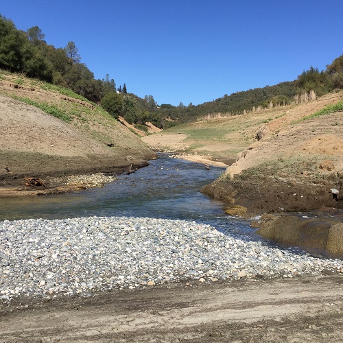
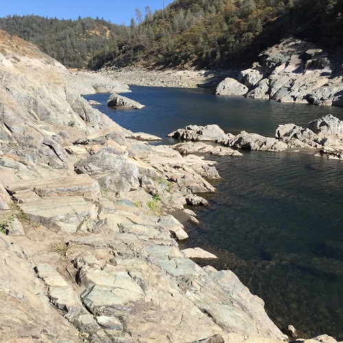
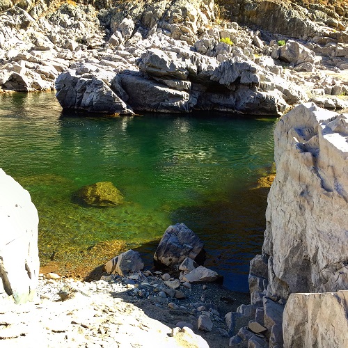
Steep rock walls line the North Fork of the American River along this stretch. Large pools of water are created in the river from bedrock dams.
North of Mormon’s Bar the landscape changes from granite boulders and decomposed granite to the metamorphic rock prevalent on the El Dorado County side of the river. The metamorphic rock does not decomposed as easily as the granite. The river has cut or scoured through this bedrock. You can easily see the bedrock mass traversing from one side of the canyon to the other side of the river. It’s amazing to think that early gold miners diverted much of the river out of its channel to reach the placer gold sitting on top of the bed rock.
1851 Daily Alta California, Volume 2, Number 231, 30 July 1851
Damming the river to drain the river bed
Damming and canaling the river
We condense from the Sacramento Union of yesterday, some interesting intelligence damming operations now carried on in the North, South and Middle Fork of the American River. The North Fork is pretty effectually dammed from Mormon Island to the Middle Fork. At New York Bar, four miles below the Middle Fork, a company of seven has just commenced washing surface earth, and is averaging over $20d per day. At Lone Bar an excellent dam has been completed, and the bed of the stream is proving very rich. Pay dirt has been washed out bringing $20 per bucket. The company at Beal’s Bar, near the junction of the North and South Forks. has constructed two races, and are draining a very large section of the stream. At Negro Bar the miners have constructed a race over a mile in length prospect encouraging. On Condemned Bar and Oregon Bar damming companies are hard at work. On the Middle Fork, the greatest work is on Murderer’s Bar. The entire stream is drained for miles, and the company commenced to divert the water which was very low, day before yesterday. On the South Fork, at Salmon Falls, there are three canal companies. The upper canal done well, but the two lower ones are obstructed in their operations by slack water. At Dutch Bar. there is a company who makes good wages by draining the water from abandoned claims. The South Fork above Coloma is crewed with companies, and the stream for many miles above that town scarcely runs over its original bed.
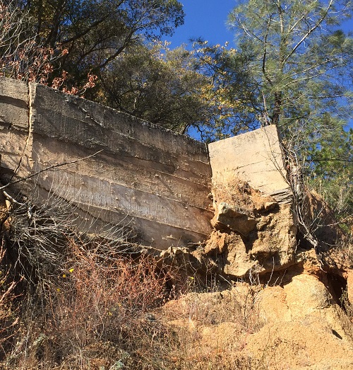
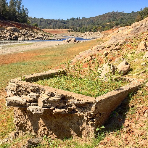
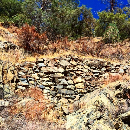
Virtually any vestige of the early gold mining days has been washed away the American River or silted over from Folsom Lake. At Manhattan Bar I did stumble across a concrete box. Framed in local rock with concrete interior, the box was mostly likely the catch basin for water from the North Fork Ditch that was approximately 40 feet above it on the hillside. The water could have then been distributed into a flume to deliver to mining operations along the bar.
North Fork Ditch Flumes and Distribution

Concrete distribution box at Manhattan Bar.
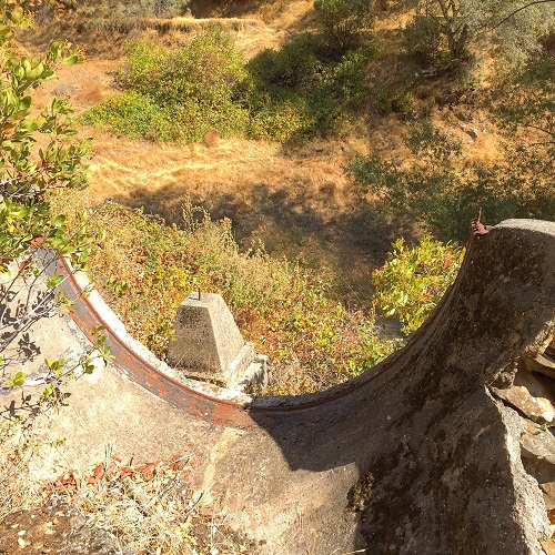
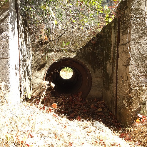
One half mile northeast of the concrete distribution box I located the remnants of a flume support across a ravine. The North Fork Ditch had originally traveled around the ravine which has a seasonal creek. At some point, probably after the 1910 concrete lining upgrade to the ditch, the company spanned the ravine with a half pipe metal flume. Just north of the flume crossing was a waste outlet. If water demand was not great enough, instead of allowing the canal water to over flow and erode or undermine the ditch wall, the operator would pull up the wooden planks and allow the water to discharge through an 18-inch pipe into the creek ravine below.
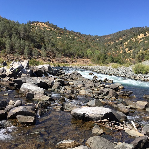
North of Manhattan Bar the canyon gets narrow and you are climbing over steep cliffs of rock. Oddly, the river is very calm through this part of the canyon. While I don’t know what it must have been like in 1850, but today there are many nice swimming holes, if you can hike to them.
I finally rested at an area where the Pioneer Express trail dips down to the river’s edge. This area is more like a debris field with angled rocks scattered all over the place. The water cascades over the rocks forming little rapids. Because the rocks are not very weathered, I have to assume that much of this debris flowed down from construction activity surrounding the Auburn Dam.
The eight mile hike took me seven hours to complete. I was much faster getting to my lunch break destination than my return trip. The constant climbing over rock walls and ledges took a toll on my legs. I would recommend the hike up to the north end of Manhattan Bar. Beyond that it can be tricky as the rock cliffs get steep and you are constantly scrambling over boulders to keep moving up river. I have no idea how the miners did it.
Picture Gallery of Hiking along the North Fork of the American River
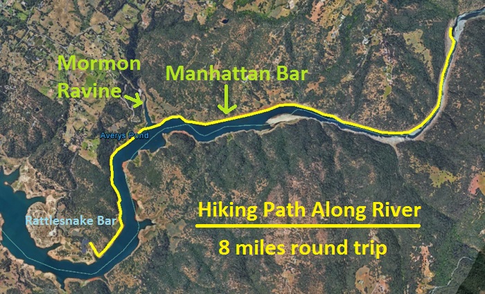
Path of my Rattlesnake, Mormon, and Manhattan Bar hike along the North Fork of the American River.
Video of the North Fork of the American River flowing over the debris field
