
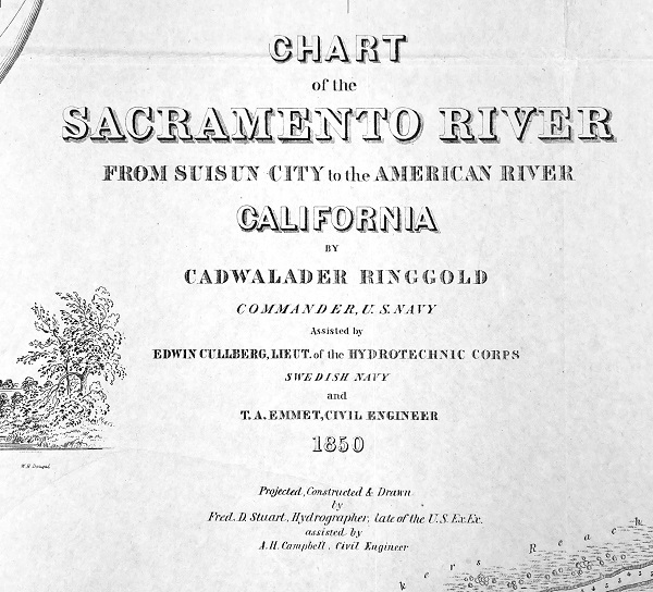
By 1849, because of the Gold Rush, Sacramento had become a magnet for immigrants seeking their fortune in the gold fields. The Sacramento River was the primary conduit for passage from San Francisco. The importance of the river corridor prompted an 1850 hydrographic expedition to map the Sacramento River and associated sloughs, along with the depth of the water. The result was the Chart of the Sacramento River From Suisun City to the American River.
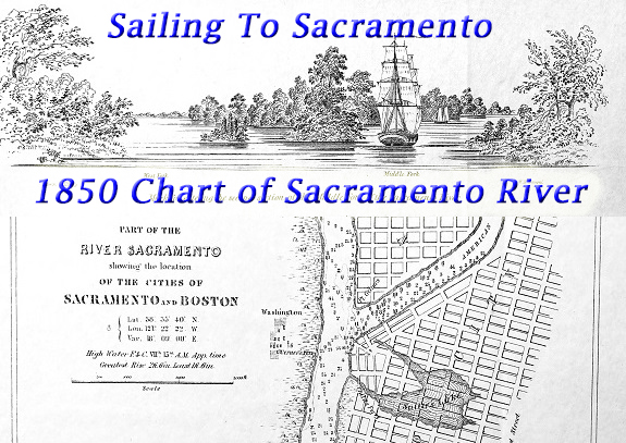
Commander Cadwalader Ringgold of the U. S. Navy led the team of civil engineers and hydrographers. The chart, in addition to creating one of the first accurate maps of the Sacramento River, also included several illustrations of the river landscape. While the chart was focused on water depths and distances, it did note some of the communities and local names for locations, which would change or disappear over time.
Chart of the Sacramento River From Suisun City to the American River, 1850
Higher resolution images may be downloaded at the end of the blog post.
The most significant details of the chart are the depths of the waterways, important for sailing vessels to navigate, tidal influences, width of the rivers or sloughs, and relative location to one another. At the location of a potential port the tidal influence is described. This is noted by the descriptor “High Water F. & C.” that stands for the high water full and change, followed by a roman numeral for the hour and minute estimate.
The tidal influence was a function of the moon’s passage over the point in question. For the Sacramento and Boston port, the chart notes the high tide will occur seven hours and fifteen minutes after the transit of the moon. The hydrographic expedition determined that the greatest rise of the Sacramento River because of the tidal influence was two feet and six inches, and the smallest increase was one foot and six inches.
The water soundings, or depth measurements, is one of the most interesting aspects of the chart. It gives us a good picture of what the Sacramento River looked like before all the levees were raised and the intrusion of massive amounts of debris from hydraulic mining. The numbers can be difficult to interpret, so I reached out to the National Oceanic and Atmospheric Administration for help in deciphering the soundings.
The whole number, and those with fractions, are fathoms. One fathom equals six feet. A sounding of 2 ¼ would equate to 13.5 feet of water depth from the surface to the bottom of the river. Numbers with a dot underneath them represent feet. Soundings of between one and eleven feet were expressed in feet, not fathoms. The number seven with a dot underneath it would be seven feet of water depth. Finally, all the depths were at the lowest calculated depth or most minimal tidal influence.
In 1850, the deepest part of the Sacramento River west of the city was between fifteen and twenty feet from J to P streets. Captain Albert Foster, who came to California in 1849, testified at the 1881 Sacramento Debris Trial about the depth of the Sacramento (Sacramento Daily Record-Union, November 21, 1881.) He noted that the depth of the Sacramento River when he first arrived piloting vessels was twenty-four feet along the city’s water front. Sailing vessels averaged a draft (that portion of the ship below the water line) of approximately seven feet and the steam ships five feet. Consequently, until the hydraulic mining debris started filling the river, most of the river and sloughs were easily navigable by most vessels.
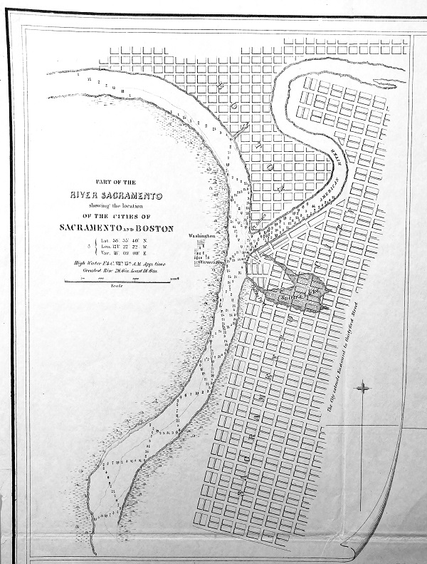
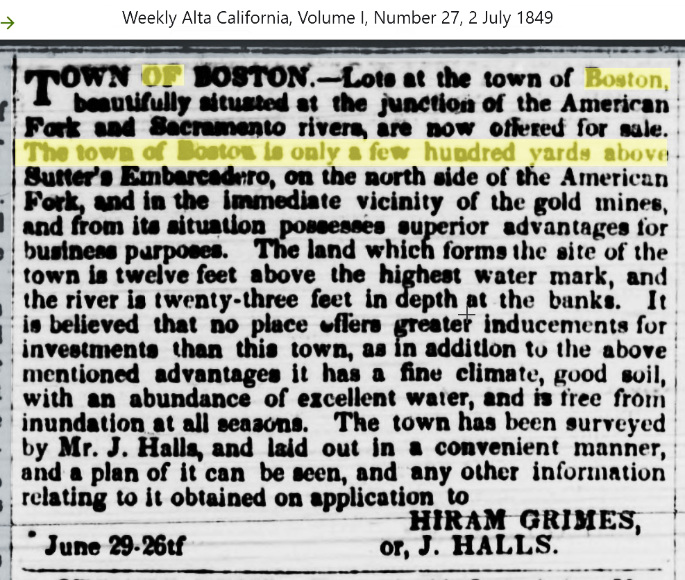
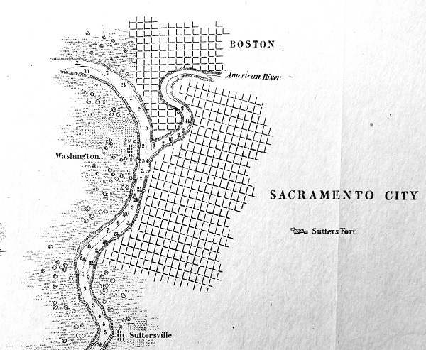
Town of Boston
The town of Boston was proposed by Hiram Grimes, nephew of Eliab Grimes who owned the Rancho Del Paso land grant. The Rancho Del Paso was on the north side of the American River across from Sacramento. Hiram Grimes acquired the Rancho San Juan which was further to the east. Regardless, Hiram had a town laid out and attempted to sell lots, but a town was never developed.
From the Sacramento and Boston inset of the chart there is a little finger of water north of the American River confluence that touches the bottom of the S in Boston. This was most likely Bannon Slough. After the 1862 floods, Sacramento began to realign the American River to enter the Sacramento River through Bannon Slough. The old alignment, south of the slough was abandon as the general consensus was the s-curve of the American River at that point exacerbated flooding issues.
Sutter’s Lake is prominently noted on the chart along with Child’s Ferry over the small connection to the lake and the Sacramento River. Over a ten-year period between 1872 and 1881, Sutter’s Lake, by that time known as China Slough, was filled with sand and silt pumped from the Sacramento River. Early river pilots described the banks of the Sacramento River at the city’s waterfront as steep and twenty feet in height above the water.
View of Riverbank at Sacramento in 1850
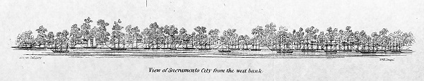
The illustration of Sacramento’s waterfront from the west bank of the river confirms these descriptions. There is no scale to the illustration, but there are at least twenty sailing ships spanning a four-block area along the heavily wooded waterfront with approximately twenty structures that range from single story to three stories tall.
Another inset of Sacramento notes Suttersville and Sutter’s Fort. A block grid for the city proper was routinely used to denote current or future development. What is interesting is the distance Sutter’s Fort is from the prospective development of the city. The few building outlines titled Sutter’s Fort conveys the distance, in 1850 terms, the fort was from either the Sacramento or American River.
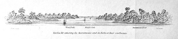
Sailing Through The Delta In 1850
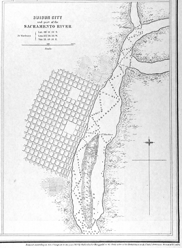
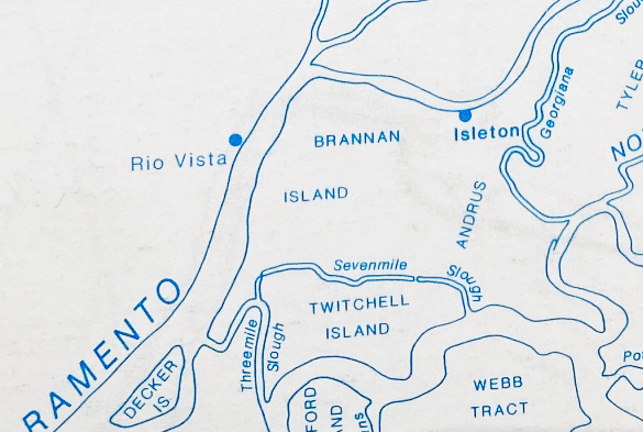
For anyone who is captivated by the Sacramento River and the Sacramento – San Joaquin Delta, the Chart of the Sacramento River provides a glimpse of how the various sloughs connected historically with the river. Even though the river has been modestly straightened with the construction of the levees, it still retains the curvatures from Sacramento City down to Rio Vista. One obvious error of prospective assumption is the location name of Suisun City for Rio Vista. Suisun City was at the terminus of another slough much further to the west. The small community that would become known as Rio Vista was located two miles to the north where Cache Slough met the Sacramento River.
The report that the map were bundled with was titled A Series of Charts, with Sailing Directions Embracing…by Cadwalader Ringgold, Commander, U. S. Navy, Washington, 1852. With reference to Suisun City, the report states, “Opposite Gillespie island, on the right bank, will be seen the site of Suisun City, selected by some enterprising citizens; it is a beautiful location, with fine land adjoining. It is not improbably that this will become, in course of time, as population increases, a thriving settlement, and town; at least twenty feet of water may be carried to this point by vessels. The Montezuma hills extend up to, and expand themselves near this point, giving to the immediate vicinity an elevation, which protect it from overflow.”
The observed location of Suisun City was correct in terms of its siting for a proper community. However, the dreams of those “enterprising citizens”, did not materialize. But the site was eventually developed and named Rio Vista. Further research is necessary to learn what became of Gillespie Island.
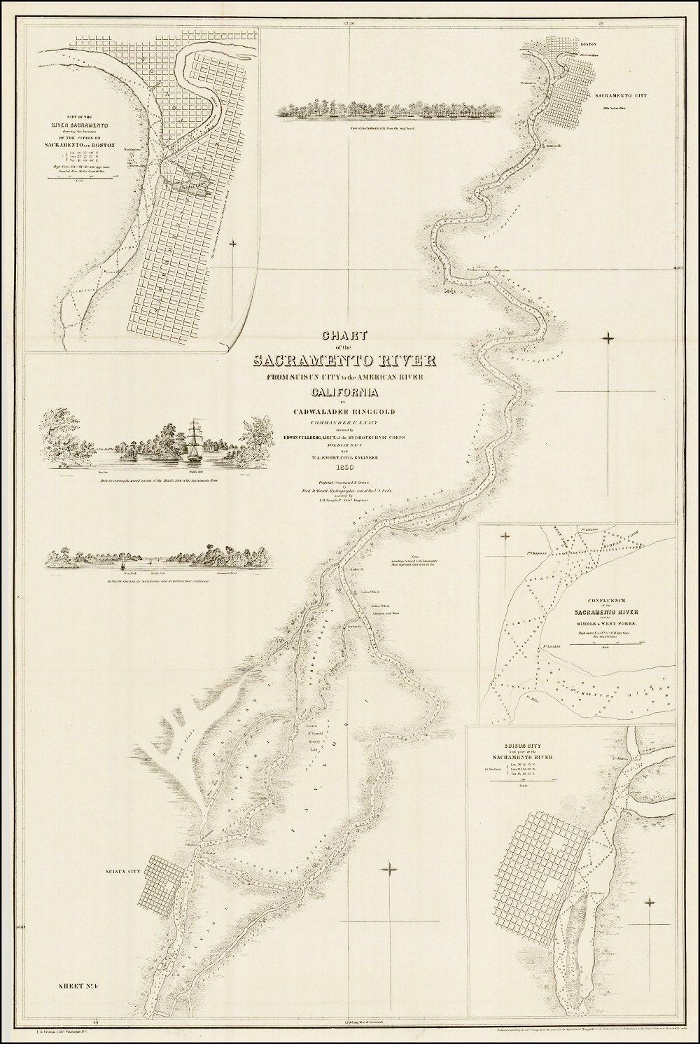
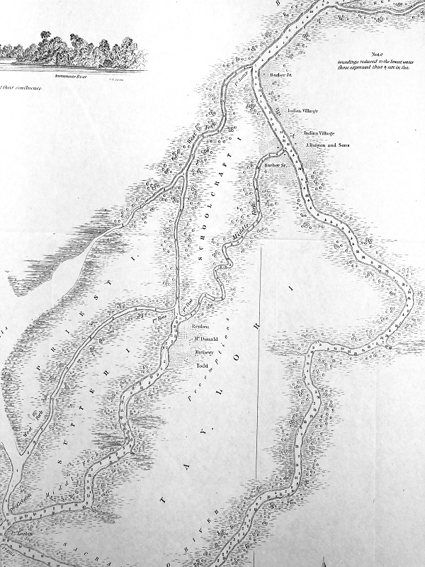
The chart mentions the forks of the Sacramento River. The west fork would be named Cache Slough. The middle fork would be called Steamboat Slough as it would become the preferred route for steamboats, slicing off several miles of transit up to Sacramento as opposed to following the main channel of the river.
Compared to a current map of the Sacramento – San Joaquin Delta, some of the dimensions of the original islands have changed or the cartographer got them wrong to begin with. It may be a mixture of both man-made changes to the Delta and map maker errors. The Sutter and Schoolcraft Islands are oversized relative to their current boundaries. Schoolcraft is now known as Merritt Island. The Priest Island of 1850 is now known as Ryer Island.
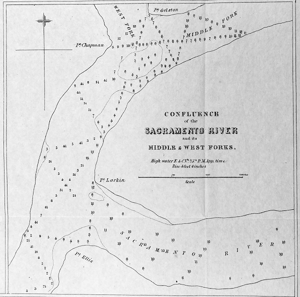
One beautiful illustration is a two-masted tall ship (I’m not sure if it is a bark or a schooner) sailing into the middle fork with another masted ship ahead of it. The illustration is captioned, “Mark for entering the second section of the Middle Fork of the Sacramento River.”
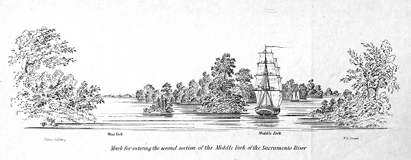
The description would seem to indicate that this fork was at Pt. Post on the southern tip of Schoolcraft Island of the original chart. Current Delta island locations would make this illustration at the southern tip of Sutter Island. Regardless, the intention, other than to provide the type of landscape encountered, was to convey to ships to veer starboard or right as they encountered the fork.
Early Delta Farmers and Native American Villages
Details of the sloughs indicate that several families were farming on Taylor (Grand) Island by the names of Reuben, McDonald, Mathewy, and Todd. Even though Steamboat Slough (Middle Fork) was not a straight line, it had a greater water depth compared to the westerly fork (Sutter Slough.) The expedition marked water depths of three to six fathoms or nine to eighteen feet. Whereas Sutter Slough has shallower water depths between one and three fathoms.
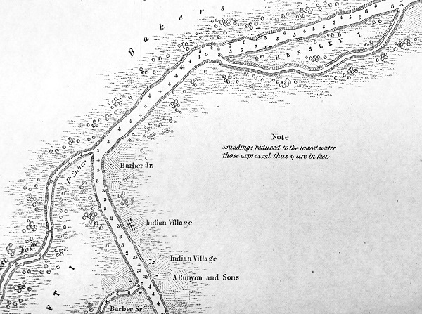
The charting expedition obviously had enough time to make the acquaintance of several of the early farmers in the area. The farms of Barber Jr. and Sr. are noted on the map and within a relatively short distance to Native American villages. A. Runyon and Sons farming operation is also noted. Solomon Runyon, who died in 1897, would go on to be a fairly large land owner in the Delta. Current Delta maps make no reference to a Hensley Island, southwest of the Sacramento River, which is noted on the chart but not sounded for water depth. It is mostly likely Randall Island north of Courtland.
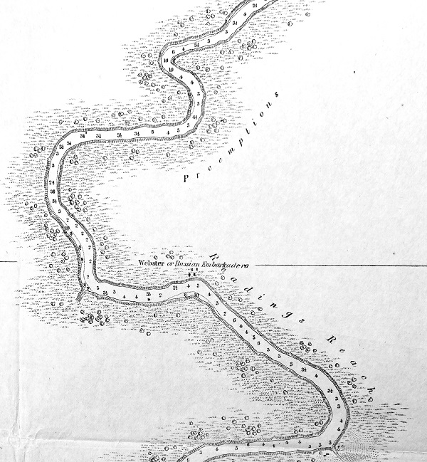
Sacramento’s Pocket and Little Pocket neighbors are outlined on the 1850 chart with the distinctive river bends providing the western boundary for these communities. The cartographer noted the Webster or Russian Embarkadero right about where today’s Freeport Regional Water Project intake is on the river. Supposedly, the Russian embarcadero was the landing the Russian’s used to collect Sutter’s products (grain, tallow, etc.) in exchange for property they sold him on the northcoast.
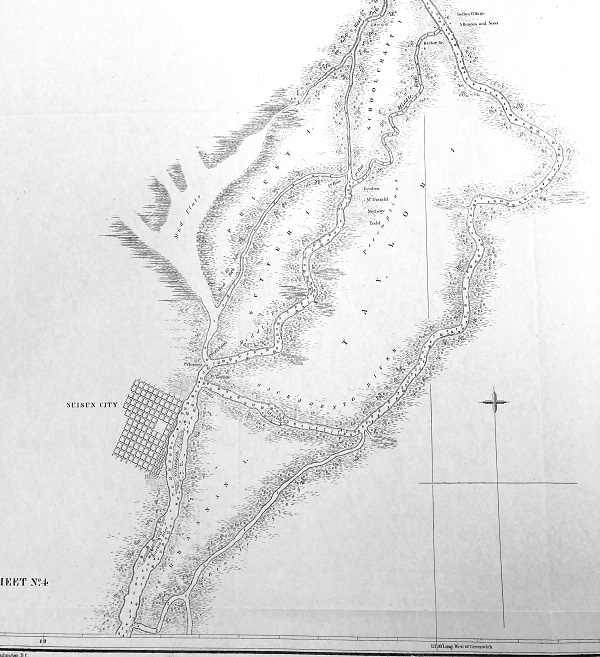
One area west of the Sacramento River that was not explored was the Mud Flats next to Priest (Ryer) Island. This area would be the outlet of the Yolo Bypass, developed over many decades, to divert high river flows in the Sacramento River away from Sacramento City. The Sacramento Deep Water Ship Channel, completed in 1963, would also come through the Mud Flats and provides a straight line for freight ships to reach the Port of West Sacramento.
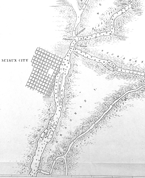
While Ida’s Isle still exists north of Brannan Island, the Larkin Isles and Gillespie Island, in front and south of the mapped Suisun City, seem to have disappeared from the Sacramento River. The chart also depicts a Hensley Slough that either no longer exists or was erroneously illustrated. The southern tip of Brannan Island accurately shows the confluence of today’s Threemile and Sevenmile Sloughs. Later maps depict a slough from the Sacramento River south, and divided Brannan Island from Andrus Island. The Hensley Slough intersection with the Sacramento River is in the approximate location of the old slough shown on a 1869 Tide Land Reclamation Company map.
Just like the Delta, you can get lost comparing old maps to the modern incarnation of the Delta water system. The 1850 chart of the Sacramento is not perfect and there are errors. The Ringgold expedition was charting numerous waterways and ports on the west coast of the United States. Consequently, the survey expedition was limited on how much time they could spend at one location. The 1850 expedition could have spent months in the Delta accurately defining every bend of the river and exploring every slough. Now, us historical map fanatics will spend months pouring over the maps looking for clues to the development of the Sacramento River and Central Valley. My next task is getting the large map framed and finding a suitable location to display it at.
1850 Chart Sacramento River Map
- 1 Sacramento American River 1850 knauss
- 2 Sac Sutter Fort 1850 knauss
- 3 Sac City West Bank 1850 knauss
- 4 Pocket Russian Embark 1850 knauss
- 5 Mud Flats Sacramento Delta 1850 knauss
- 6 n 8 Suisun City Rio Vista 1850 knauss
- 7 Confluence Sac Middle Fork 1850 knauss
- 9 Brannan Island 1850 knauss
- 10 Sutter Island 1850 knauss
- 11 Indian Villages 1850 knauss
- 12 Three Forks Sac River 1850 knauss
- 12a Steamboat Slough Sac River 1850 knauss
- 13 Sacramento River Chart Title 1850 knauss
- Sacramento River Chart Full Map 1850 knauss
