Rose and Rock Springs are normally covered by Folsom Lake.
Always more valuable than gold for early California prospectors was water. I had always noticed Rose Springs and Rock Springs marked on maps that encompassed the south Placer county region we know today as Granite Bay. It wasn’t until Folsom Lake hit historically low water levels that what I think are Rose and Rock springs became apparent to me. Photo gallery at end of post.
Old maps marked springs for travelers
You will see all sorts of water features marked on early maps including springs. These water sources were invaluable for travelers that needed water not only for themselves but their livestock that were carrying supplies or pulling wagons. With the construction of Folsom Dam and neighboring development I figured actually locating the springs was lost to history. Both Rose and Rock Springs are marked on several old maps. They indicated not only the water source but small communities of homes or businesses as well.
Rose Spring creates wetlands on dry Folsom Lake bed
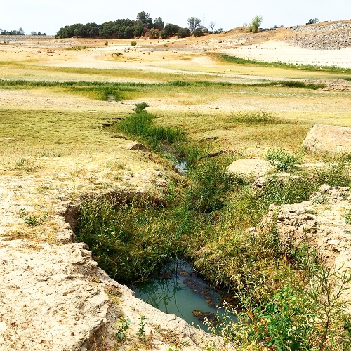
In September 2015 I noticed one area near Dyke 5, which is parallel to Auburn-Folsom Road, had become a green wetland supporting geese, kill deer, and a variety of grasses in spite of the drought shrunken Folsom Reservoir. This wetland at approximately 400 feet in elevation was at least forty feet above the lake elevation. The shoreline of the lake was a good half mile away. From this little pond, a continuous trickle of water wound its way to Folsom Lake during the hottest days of temperatures topping 100˚ F degrees.
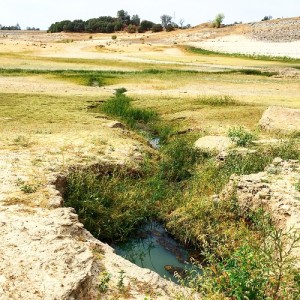
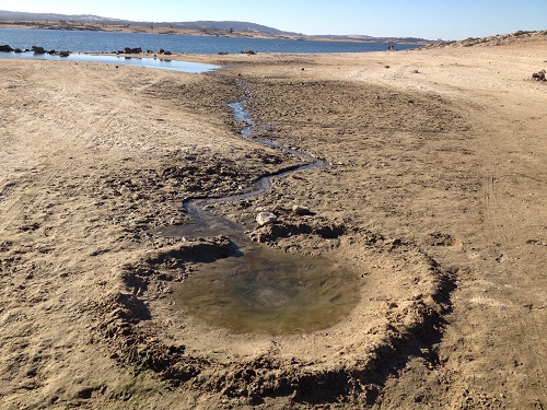
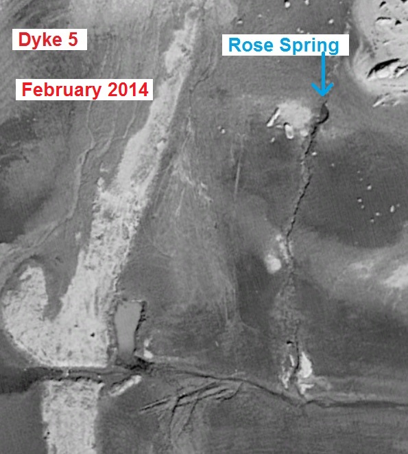
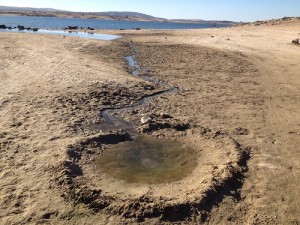
A deep hole, site of Rose Springs, is constantly filled with water that makes its way down the hill side to a shallow pond. This picture is looking south towards Beal’s Point and Dyke 5 is visible in the upper right hand corner.
What is feeding the springs?
Where was this water coming from? I looked for obvious clues of residential or commercial water leaks. To the south is Beal’s Point but it couldn’t be supplying the water because the originating water pool was on the opposing slope. To the west is Dyke 5 with its own drainage down to Auburn-Folsom Road which is below the spring. To the north, above the spring, is a ridge of granite topped with lahar, a mixture of river cobble and soil deposited from ancient volcanic events.
Placer gold on top of bedrock
On top of this ridge was the pit or hole to an old gold mine the entrance of which was located on the north slope of the ridge on a horse boarding facility. One theory is that the miners attempted to tunnel down through the lahar to granite bed rock. It was always on top of the bedrock, whether an active or ancient river bed, that the most placer gold would be found. If this current spring of water is in fact Rose Springs marked on old maps it would be logical to assume from a miner’s perspective that on top of the ridge had been an old river bed with gold.
Rose Springs west of Folsom Lake
However, when I look at the old maps Rose Springs is generally marked further west than the current location on the east side of Dyke 5. While old maps aren’t celebrated for their accuracy, the landscape has changed. It’s possible that the Rose Spring the early pioneers encountered was actually a pool of water that was fed by the current location but not visible above ground. Instead of the spring water traveling west toward Folsom Lake, it now flows east for a very good reason.
Rose Springs had created a beautiful oasis on the dry lake bed of Folsom in 2015. Behind the pond rises the ridge of granite topped with lahar or a mixture of mud and smooth river cobble rock on top. It was on top of this ridge that a shaft to an old gold mine was flooded with water by the Bureau of Reclamation to see if it popped out of the hillside. None of the 2,000 gallons of water was ever visible after the test.
Dyke 5 drainage cut
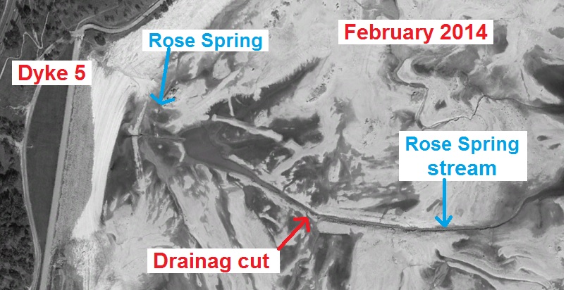
When Folsom Dam and the associated dykes were being planned it was obvious to engineers that Dyke 5 would create a trapped pool of water as the reservoir was drained during the summer months. This is because the base of Dyke 5 was lower than a little saddle of land between current Beal’s Point and the ridge to the north. Consequently, they created a channel in the soon to be lake bed so the water at the base of Dyke 5 would drain toward the American River to the east.
Pool of spring water during historic drought
There are two holes that fill up with water and eventually spill into the channel. I’m assuming the enlarged holes were excavated by the Bureau of Reclamation to keep an eye on this water source. While that may sound a little odd, the Bureau of Reclamation is always vigilant about any void that might undermine one of the dykes or wing dams. (See Bureau of Reclamation attempts to flood Granite Bay gold mine.)
The ridge absorbed all the water
I watched as the Bureau of Reclamation attempted to flood a large mining hole on top of the ridge with 2,000 gallons of water in less than a couple of hours. They wanted to see if the water would reveal any voids near the dykes which threaten the integrity of the dam. No water was ever visible from any side of ridge indicating that at least the lahar or mixture of river cobble and mud on top of the granite ridge had a large capacity for water storage. Possibly it is this water storage from winter rains that feeds Rose and Rock Springs during the summer months.
Very dry surrounding summer landscape
Except for the ridge of granite and lahar to the north of this spring, I can’t determine any other source of its water. All the surrounding potential water sources are lower in elevation and Linda Creek on the north-west side of the ridge would be the natural drainage for other residential or commercial water supplies. Also consider that in the summer of 2015 residential water consumers had restricted their water use at the behest of the San Juan Water District. We were conserving over 25% from summer 2013 levels. Linda Creek was completely dry east of Auburn-Folsom Road as no one was letting landscape irrigation run down the gutters into the storm drains.
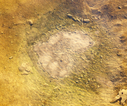
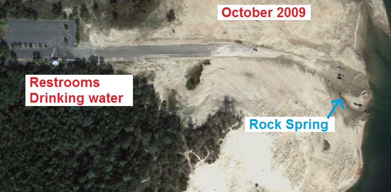
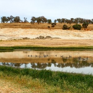
In early spring, as Folsom Lake receded, a child had created a small berm around the bubbling Rock Spring. You can see how the spring water trails off to the lake or originally the N.F. American River.
North Fork Water ditch abandoned with Folsom Dam
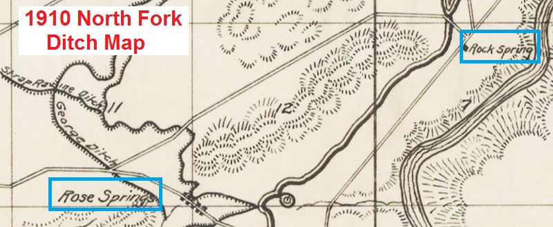
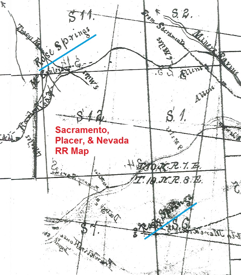
Where this spring sits today was next to the approximate location of the George or Allen Ditch (depending on which map you reference) which was a branch of the North Fork Ditch. (See North Fork Ditch History and 1910 American River Water Canal Map.)The Allen Ditch served mines and farms to the north and terminated at Miners Ravine Creek. Dyke 5 cut off the Allen Ditch so they installed a siphon pipe from the existing Rose Springs Ditch in front of Dyke 5 to continue service northwards to properties along today’s Douglas Boulevard. (See Tracing the route of the Rose Spring Ditch.) This ditch was abandon several years after the new plumbing was installed in the 1950’s or 60’s. The old and short-lived Sacramento Placer and Nevada Railroad also passed along the old Allen Ditch and Rose Springs. (See Sacramento, Placer and Nevada Railroad History.)
Rose Spring fills a hole of water during summer
The holes excavated by the Bureau of Reclamation, possibly when Dyke 5 was strengthen and renovated back in 2009, are a couple of feet deep and always filled with water. While I’ve never seen any water bubbling out of these pools or springs, there is a constant flow of water feeding the little wetland area and a trickle of water continues to meander toward the lake to the east.
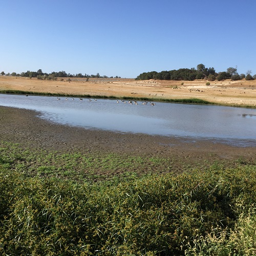
Rock Springs discovered?
A two miles east of Rose Springs at the eastern base of Mooney Ridge I have seen water inexplicably percolating out of the ground for years on my weekend hikes and runs. As the lake receded, a little puddle of water would always be bubbling away. The water would trickle down toward the Lake even on the hottest summer day. I assumed that this water was from the Granite Beach restrooms and drinking fountain at the southern boat launch site. Even though this potable water source was a quarter of a mile up the hill, I figured there must be a water leak feeding this little spring.

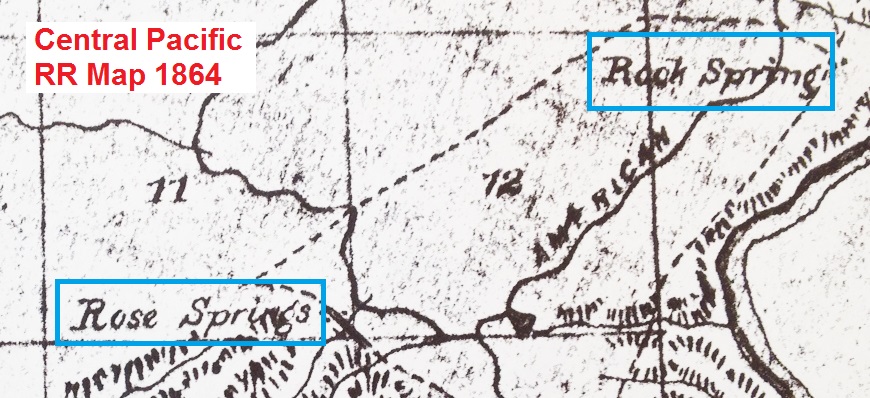
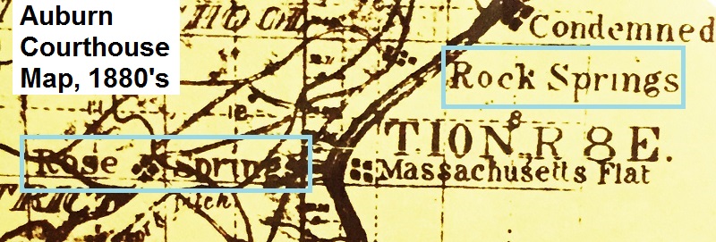
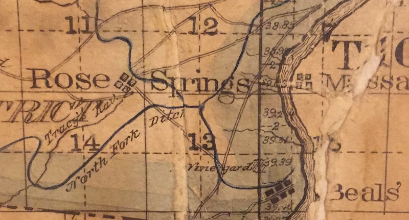
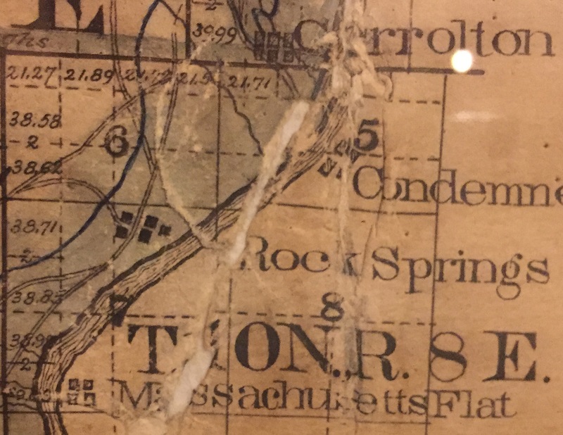
A 1910 map of the American River and Natomas Mining and Water Company depicting the approximate location of Rose and Rock Springs. Note the water ditch from the main North Fork Ditch wound between the ridges. North Fork of the American River is the wide wavy lines on the right of the image. The ridge with the 12 in the middle of it is essentially Mooney Ridge. The dark line with a parallel thinner line is the North Fork Ditch.
Correct location for Rock Springs on old maps
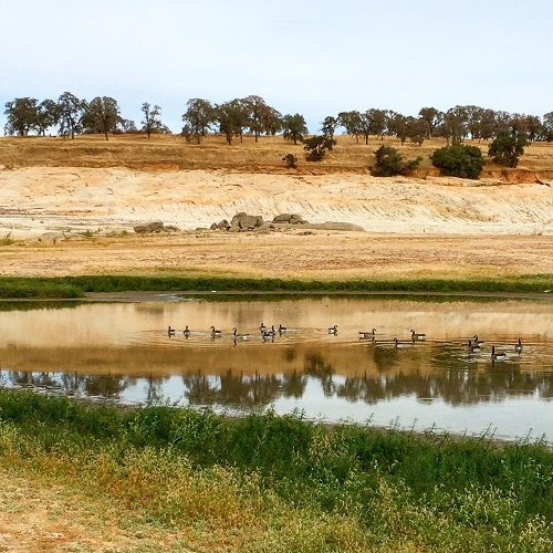
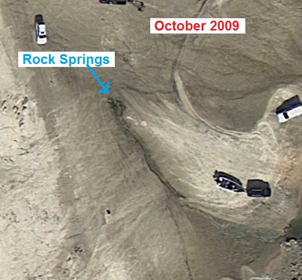
A Folsom State Park water leak may still be the source of this little spring. But one would think that the water would have percolated to the surface much sooner as it encounters the granite bedrock of Mooney Ridge. This little puddle and ribbon of water just happens to be in the approximate location of Rock Springs marked on old maps. Because this constant flow of water doesn’t threaten any dam structure it has not been excavated by the Bureau of Reclamation. More map images below.
Rose and Rock Springs usually covered by Folsom reservoir
When you look at the old maps Rose Springs is consistently located between what is today’s Beal’s Point on the south, a ridge on the north, and Linda Creek to the west. Rock Springs is always marked at the base of Mooney Ridge west of the North Fork of the American. Today, both springs are within the reservoir created by Folsom Dam and are only visible when the lake elevation drops below 400 feet.
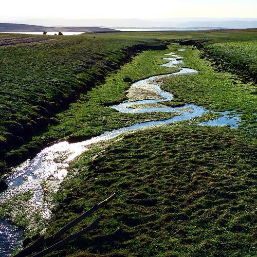
Warm weather and spring water make grass grow
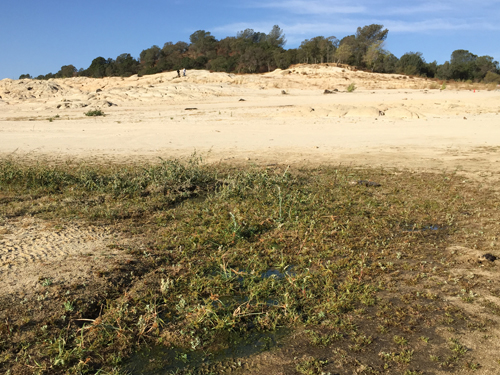
Initially, as the Folsom Lake receded, the spring water just trickled through the barren landscape that had been smothered by forty feet of lake water. But as the summer wore on the continuous moisture allowed a variety of grasses to grow along the edges of Rose Spring stream and the small pond next to Dyke 5. Rock Spring has also grown some grass but this area receives much more traffic from people and cars as it is at the end of the boat ramp and much closer to lake shore. It’s almost ironic to think that the Bureau of Reclamation may have inadvertently created a protected wetland when Folsom Lake drops so low. The Rose Spring stream is truly an oasis in the middle of barren rock and dry lake bed. I’ll be somewhat sad to see it covered up when the lake rises with winter rains.
Recording of Rose Spring pond and stream, October 2015
Rock Spring Video
Recorded on November 29, 2015 when Folsom Lake was at a historic low of 15% capacity, 351 feet elevation. The little spring is bubbling even with sun parched landscape all around.