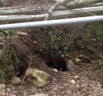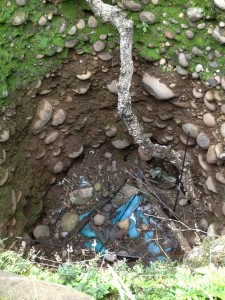
Clearly visible inside the ridge pit are the round cobble stones and trash at the bottom of the hole.
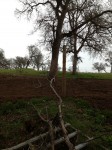
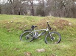
This part of the trail was never my favorite. It always seemed strange to me that this trail in Granite Bay over the ridge between Dyke 4 and 5 on Folsom Lake was full of round cobble stone rocks set in red dirt that always caused me to stumble while running. Most of the other trails around Folsom lake were decomposed granite. Even though I had researched the area’s history, I never thought this rocky ridge was part of it. As I connected all the information, I am fairly certain this ridge held a historic gold mine, at least for a short time.
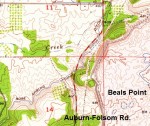
My son who had explored the ridge, which sits between Mooney Ridge and Beals Point, had told me of a big pit at the top of the hill but I never got around to exploring it. I even remembered reading a story in the Sacramento Bee about a potential mining tunnel at the bottom of the hill* that was uncovered when they were widening Auburn-Folsom from two to four lanes. Finally, it was an email from a gentleman who had found my website with old photos of Folsom Lake and believed he had found the entrance to a historic mine in Granite Bay.
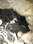
As I peered down the mine shaft at the tunnel entrance I was surprised at how deep it was. With
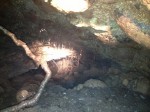
Looking down the Granite Bay mine shaft, notice the smooth cobble stone rocks and length of excavation.
water dripping off the roots from recent rains, the sides of the tunnel were comprised of the same cobble and red dirt as the trail and pit up top. The shaft is easily thirty feet in length and excavated at a forty-five degree angle. On top and along the sides of the ridge are depressions clearly excavated years ago. Some of the depressions seem to run in alignment with with the mine shaft and larger pit on top of the ridge.
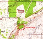
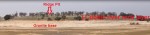
The bigger question in my mind was, “Why was there a mine shaft on this ridge?” This hill would have been easily seen from the mining camps along the north fork of the American River in the 1850’s. While the north and south forks of the American river, now under Folsom lake, were full of panning and sluice operations, there was really no hard rock mines in the area. What drew someone to open a mine shaft in the side of the hill and dig a substantial pit on the top? (see also North Fork and Rose Spring Ditch history and Sacramento, Placer and Nevada Railroad)
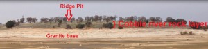
Profile of ridge looking north from Beals Point at low lake level. North Fork Ditch would have run from right to left in this picture.
What is unique about this particular ridge is the fairly uncharacteristic soil and geology that comprises it. Instead of the ubiquitous decomposed granitic soil and granite outcroppings, the ridge exhibits unconsolidated smooth cobble rocks held together by sticky red clay I often associate with the foothills. This massive rocky ridge sits atop a foundation of granite that is visible from the road cut below.
Undoubtedly, this enormous pile of smooth river rocks was deposited thousands of years ago by
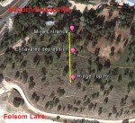
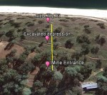
Aerial view of alignment of pit, depression and mine entrance.
massive floods, volcanic mud flows or ancient river. Upon first glance, the constituents of the ridge, round, water smoothed cobble stones, looks as if they should be in Folsom, Rancho Cordova or along Mississippi Bar. From a miner’s perspective, this is just the sort of ancient river bed that might hold placer deposits of gold.
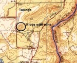
With the mine entrance so high above the river I wasn’t sure how they could have gotten water to work the soil deposits they excavated. I stumbled across a history of the North Fork Ditch that described how it was finished in 1856. The North Fork Ditch was a 33 mile water ditch that ran from above Auburn following along the north fork of the American River. There was a spur of the ditch that conveniently ran along the west and side of the ridge which is now Auburn-Folsom Rd. Where that leg of the ditch turns west is the site of identified tailings on 1944 and 1954 U.S.G.S. topographical quadrangle maps. This answered another question for me, “Where did they put all the rock that they mined?”
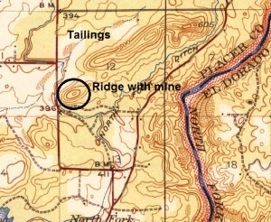
1944 USGS quad map showing North Fork Ditch and tailing to the north of the mine in the ridge. The curved road between BM 411 and 396 is the old railroad grade for the Sacramento, Placer and Nevada Railroad.
While it is pure speculation, it would not be unreasonable for the mined soil to be moved off the ridge a couple hundred yards north to the intersection of the ditch and Linda Creek. At this spot the soil could be put through the sluice boxes and washed into the creek. The large cobble stones were discarded around Linda Creek just west of what is now Cavitt Junior High School.
Someone with more mining knowledge might be able to explain the the excavated pits at the top and the numerous depressions that dot the ridge. Were these vertical shafts that intersected with the main shaft below for air or light? Did the mine shaft that was found and reported in the Sacramento Bee have any connection to this gold mining operation? When was the mine active?
Without finding any specific artifacts or notations on maps it is hard to guess when the mining operation may have begun and ended. Most likely it started after the North Fork Ditch was completed and the placer deposits along the American River played out. The Sacramento, Placer and Nevada Railroad line also ran right between Beals Point and the ridge between 1862 through 1864. Perhaps the old railroad line piqued the interest of miners in the area when the railroad was being constructed and operated.
But the motherload of all questions, “How deep is the mine shaft and where does it go?” For us
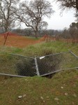
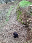
Ridge pit has been hastily covered by Park Rangers after how many years of being open?
history buffs one can only wish that someone with remote camera on a cable will want to feed it down the shaft. Until that happens we’ll just have to keep researching old maps and accounts of the area. Regardless, you don’t always trip across an old mine in Granite Bay everyday.
A special thank you to Craig Cova for his assistance and information in locating the entrance to the mine and history. Other blogs on local history topics: Folsom to Roseville: California Central Railroad
Rose Spring irrigation ditch had a siphon under Auburn-Folsom Rd. and another below Dyke 5. 1944 USGS Topo quad.
*Upon further research it looks as if the tunnel uncovered by the road widening of Auburn-Folsom Rd. was perhaps the abandon siphon of the Rose Spring Ditch. This ditch, extended from Baldwin Reservoir was meant to continue water service stopped by the building of dyke 5 that effectively cut off the North Fork Ditch spur around the ridge. To maintain the elevation for gravity flow they had to employ to siphon portions, one running Auburn-Folsom Rd. and another in below dyke 5.
Click on any of the photos to enlarge.