To see the combination of man’s greed coupled with a complete disregard of nature or other people, travel to Malakoff Diggins State Historic Park to see the results of hydraulic mining. After the easy gold was panned out of the stream beds, more innovative miners turned large scale excavation to extract gold dust mixed in ancient river bed in the 1850’s – 1880’s
Just as any small boy will tell you, there are few things as fascinating as washing away dirt with an open hose. That is essentially what they did at Malakoff Diggins. After the hydraulic mining was stopped by court order in 1884, we are left the historic scar to wander around.
When ever I visit a historic place I try to put all the pieces together. I am fascinated by the logistics, engineering and aspects of daily life scattered about. When you stumble upon a historic place like Malakoff Diggins you often wonder, “How in the hell did they find this place?” There are plenty of sources of historic information on Malakoff Diggins. I just wanted to pose some questions and offer some photos that I took of our experience.
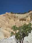
130 years after the water cannons were silenced, significant scarring remains. Willows trees and brush, phreatophytes, are growing thick (I got lost in them) and trying to reclaim the pit. We are still left with a 7,000 foot drain tunnel and the lingering effects on the Sacramento Valley from the elevated river bottom that all of the hydraulic mining drained into.
I have lots of questions, so if you have lots of answers, please feel free to add a comment.
1. What is the parent material of the exposed eroded soil? The soil is a light gray or white. It almost looks like the parent material was volcanic ash. The rocks and pebbles in the pit are mostly round and smooth so they were obviously in moving water long before they were left high and dry in Nevada County.
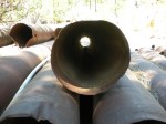
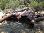
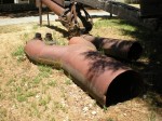
2. What iron alloy was the penstock pipes made out of? Look closely at the large pipes scattered along the pit floor and you’ll notice they were flat sheets rolled and seamed to make the pipe. Additionally, all of the connections and fabrications were done with straps and rivets? Arc welding, was not universally available until the late 1870’s. Certain steel can’t be easily welded anyhow. There is one flange that has welding marks but I don’t know if it was from the period or from after the mine closed. The welding is and cutting of the flange is pretty crude, so it might be from the 1870’s.
It took a while, but I finally found some information about the termination of the 7,800′ drain tunnel. On our next trip up to Malakoff, we’ll hike down to the exit to take pictures. However, walking through the Hiller tunnel was fun. The red clay soil sticks to everything but the white powdery soil washes off easily.
I almost feel guilty revelling in the history of Malakoff Diggins. The heart ache and misery this mining operation caused to farmers in the valley and destruction to our rivers and San Francisco bay was enormous.
Click on thumbnails to enlarge photos.
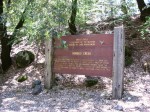
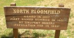
Sign on Yuba River marking Bloomfield tunnel exit one mile up Humbug creek.
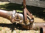
Flange welded to pipe size reducer. Arc welding was not common in the 1870’s. Is this flange and ragged welding cuts original to the hydraulic operation?
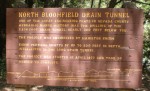
Hiller Tunnel sign
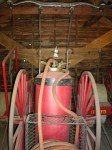
Old pipes that brought water to the hydraulic monitors were called penstocks and could be under several hundred of water pressure.
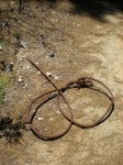
Old material and cables are just lying around Malakoff Diggins were they were left when mining ended.
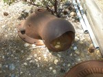
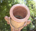
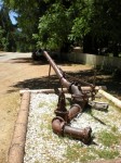
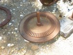
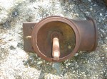
Cast iron round knuckle swivel allowed the barrel of the monitor to be easily moved up, down and side to side.
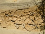
Chalk white soil. What is the parent material? Volcanic?
Fine colloidal clay material continues to settles in the pit. When it dries, it makes hard chips. There is a lot of this clay in the San Francisco bay to this day.
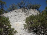
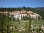
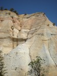
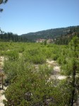
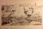
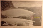
Malakoff Diggins looking east.
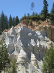
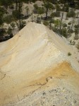
Crazy castle sculpted peaks of Malakoff soil.
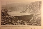
View of Malakoff Diggins looking north.
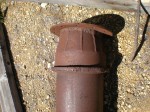
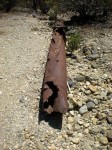
Old pipe at least 140 years old still actually pretty strong even with the rust.
Penstock pipe or lateral line used to carry water to the monitors.
Malakoff ridge, continually eroding, never a chance for vegetation to grow.
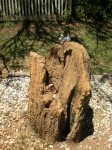
Petrified wood around a drinking fountain in North Bloomfield town.
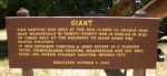
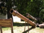
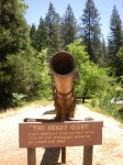
End of the barrel of the a giant monitor, 5,000 – 7,000 gallons per minute.
Giant monitor sign
15′ barrel length gave the water stream a straight shot at the hillside.
My son was convinced there was still gold at Malakoff. He left disappointed that he didn’t find any nuggets.
Hendy monitor, largest of hydraulic cannons.
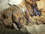
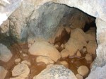
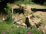
Seeping clay and water in the Hiller tunnel.
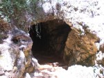
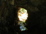
North entrance of the Hiller tunnel
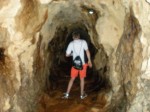
Walking through the Hiller tunnel, 6′ in height most of the way.
South entrance of the Hillar tunnel.
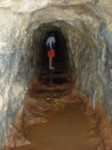
Water still runs through the tunnel.
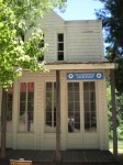
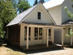
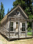
Malakoff Kallenberger barber shop
Malakoff Kings saloon
Malakoff Lafeyette hotel
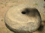
Malakoff livery hole rock. Probably used to grind corn and wheat at one time.
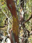
Malakoff manzanita
Malakoff north Bloomfield sign
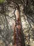
Malakoff old pressure pipe lying around at the site.
Steep erosion pit view.
Not sure why they needed a fire tank when they had several thousand gallons of water flowing per minute to the pit right down the road.
Wye fitting, notice the straps, rivets and creased seem holding the pipe together.
Foundation of the Skidmore Saloon
Small water monitor.
Inside the Hiller tunnel looking south.
Swivel joint of the monitor, all cast iron.
Interior of the monitor swivel. Notice the ridges that were stops so the monitor did not get out of hand with all the water flowing through it.
Spindle in the monitor swivel that helped hold it all together.
Vertical drip lines created by water dripping off the roots of the manzanita plants above.
Malafoff pit view looking west.
Penstock wye pipe, massive water delivery.
Historical hydraulic mining photos acquired in 2014
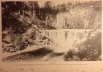
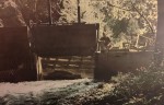
Log Dam for impounding tailings from a hydraulic mine. The material behind the dam is tailings from a hydraulic mine. c 1890 Upper Slate Creek.
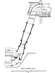
Diagram of a hydraulic elevator. A jet of water that blasts the placer gravel up (elevates) to sluice box for separation and removing gold from slurry. 1940
Hydraulic Elevator, Bloomfield Mine, c 1890 above Nevada City.
Brush Dam, North Bloomfield Company, For impounding tailings. Dam is in the washed-out ground. It is sixty-five feet high and is raised as the tailings accumulate. The impounded tailings may be seen in the artotype. Nevada City c. 1890
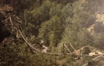
45 inch water pipe for hydraulic mining supported by suspension bridge in Trinity County. The Swanson Mining Corporation also used this water for power generation to pump the water to the mines.
Campbell Creek diversion into the flume and water pipe carried by the suspension bridge to hydraulic mining activity near Salyer, CA, 1930 (?).
Spring Valley Mine, Butte County, Oroville, hydraulic mining, photo shows entrance of 3,000′ tunnel that led to Sawmill Ravine, Dry Creek. “Two streams piping. Gravel is washed into the deep bedrock cut which leads to the tunnel seen in the background, right hand side of picture. This tunnel is three thousand feet long, and driven to get outlet for the tailings.”
"Education Before Enrollment"
Kevin is an independent agent for health insurance in California and a Certified Insurance Agent for Covered California. CA LIC. 0H12644. Focusing on families, individuals, self employed and small business. Representing several insurance carriers plus Medicare Advantage and Part D Plans. I blog on several topics to provide consumer information for people who have questions about health insurance and the Affordable Care Act. Author: "Hidden History Beneath Folsom Lake", "Benjamin Norton Bugbey, Sacramento's Champagne King", and "Amos Catlin, The Whig Who Put Sacramento On The Map."