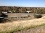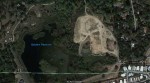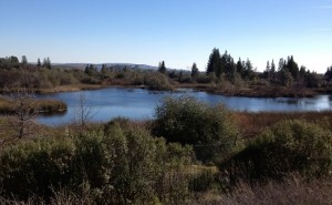
Baldwin Reservoir is now a wetland preserve.
Like a favorite garden path, the trails of long forgotten water ditches winding through the barren landscape of a drained Folsom Lake beckoned me. Where did the water ditch come from? Where did it lead? Who built these concrete lined conveyance systems now filled with silt and sand?
Gold mining water project
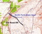
The North Fork Ditch was started in 1854 and completed in 1856 by the American River Mining Company. A dam was installed on the north fork of the American river east of Auburn at Tamaroo Bar to supply the ditch with gravity fed water. It snaked along canyons and the river bank eventually ending at Mississippi Bar on the American river. The general dimensions ditch consisted of a 5′ bottom widening to 8′ across the top with enough depth to carry 3′ of water.
Its primary purpose was to supply water to the gold mining operations at Rattlesnake Bar and


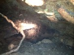
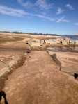
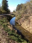
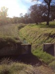
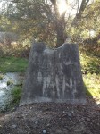
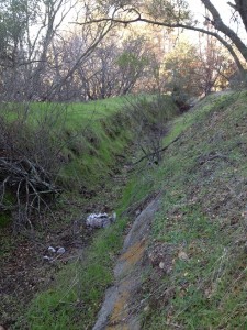
Exposed concrete lining of North Fork Ditch looking toward Mooney Ridge.
similar placer mining operations down river to Mississippi Bar in Sacramento County. The North Fork Ditch Company was entitled to 3,000 miners’ inches as determined in a law suit brought against it by The Sacramento Electric, Gas and Railway Company (SEGR) in 1898. The SEGR was operating the Folsom Power House and was at times left without enough water to put through their own canal on the American River to work the turbines to generate electricity.
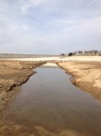
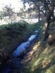
A small river of water in a ditch
The 3000 miner’s inches (1/50 of cubic foot per second) translates into 60 cfs or 448 gallons per second. Typical flows today, a combination of regular river flow and releases from dams, ranges from 1,000 to 1,800 cfs in mid-January. Obviously, back in the late 19th century before all the dams were built, summer time flows on the north and middle forks of the American river could have been much less after the snow pack had melted.
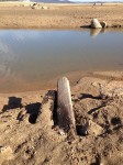
Built entirely with picks, shovels and hand labor to construct flumes, various parts were washed away over the years from the raging flood waters of the American River. Total cost for the two year construction and 33 miles of ditch was $180,000. Between 1915 and 1925 the North Fork Ditch was lined with concrete. This was to stop the estimated 70% loss of water due to seepage from the porous soil it traversed. After acquiring some land from the Hinkle family, the North Fork Ditch Company built a reservoir south of Beals Point in 1916. (see also post on California Central Railroad and Sacramento, Placer and Nevada Railroad)
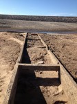
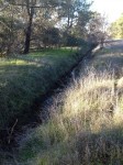
North Fork Ditch engineered slope
With the North Fork Ditch beginning at Tamaroo Bar at approximately 500′ elevation traveling

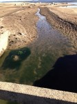
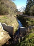
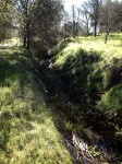
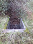
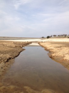
Water way leading to the old North Fork Reservoir built in 1916.
down to the North Fork Reservoir at 400′ elevation, there was an elevation drop of 7.7 feet per straight line mile. The North Fork Ditch at the outlet of the second siphon between Auburn Folsom Rd. and Dyke 5 is at 406′ elevation. Consequently, the outline of North Fork Ditch will trace a fairly constant elevation line descending ever so slightly as it travels south.
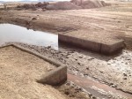
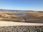
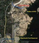
Reservoirs full of water
What is unclear through my research is if the Hinkle Reservoir mentioned in 150 Years of Water: The History of the San Juan Water District is the same as the North Fork Reservoir shown in older USGS topographical maps. The North Fork Reservoir was situated right at the base of proposed Folsom dam. It was filled and a new reservoir, named Hinkle, was built to west of the dam in the 1950’s.
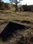
Baldwin Reservoir was built in 1928 for additional storage to meet the growing agricultural and suburban drinking water demand from Orangevale, Fair Oaks and Citrus Heights. With the construction of Folsom dam beginning in 1948, the North Fork Ditch Company built the Rose Spring Ditch to continue surface deliveries to properties due to the impending destruction of part of the North Fork Ditch by Dyke 5.
Rerouting ditch water around Folsom Lake
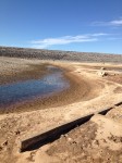
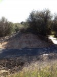
Berm and concrete used to create Rose Spring Ditch around Folsom Lake.
The part of the North Fork Ditch I call the “spur”, split from the main ditch north of Beals Point. It traveled west and then north around a ridge to provide water along current Eureka and Auburn Folsom roads. The spur ditch was situated right where the Bureau of Reclamation was to build Dyke 5. In order to maintain the gravity flow, the new Rose Spring Ditch had to be constructed at an elevation that would feed the original North Fork Ditch spur at about 410′ elevation. This put the Rose Spring Ditch above Baldwin Reservoir which was at 400′ elevation.
The new ditch wound around the hill sides of the current Folsom Lake Estates and required two siphons. One siphon went underneath Auburn Folsom Rd. west of Beals Point and another in front of Dyke 5. The widening of Auburn-Folsom Rd to four lanes in 2011 removed part of the Rose Spring Ditch. I suspect the outlet of first siphon under Auburn Folsom road was destroyed as I was only able to find the ditch and no opening that would have fed it water. Most of the Rose Spring Ditch is still intact and winds around the west side of Folsom Lake. The entrance and outlet of the second siphon are still visible as are the concrete stands that supported a 24″ pipe in front of Dyke 5.
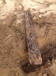
Rose Spring Ditch dries up
I have no information when the operation of the Rose Spring Ditch was abandoned. Most likely

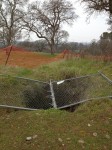
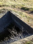
Concrete support for Rose Spring Ditch siphon.
water deliveries stopped sometime in the late 1950’s or early 1960’s when agricultural, ranching and any remaining mining operations gave way to suburban development. However, there is still one little tail of the original North Fork Ditch spur that extends from the outlet of the second siphon and runs a couple hundred yards north stopping at Auburn Folsom Rd. A brief history and other notes on the North Fork Ditch north of Granite Bay can be found in the 2008 LBHA Newsletter. [download id=”39″]
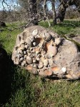
Placer mining on the ridge
My research has not determined if the North Fork Ditch spur was part of the original line or not. A 1887 Placer County map hanging in the historical court house in Auburn shows that the Natoma Water and Mining Company, the originators of the North Fork Ditch, is listed as having a placer mining claim in Township 10 North, Range 7 East. This area happens to include the old mine entrance on the ridge over looking the North Fork Ditch spur.
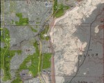
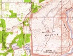
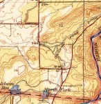
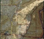
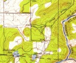
It could be the North Fork Ditch was extended in the form of the spur to provide water for this mining operation. Old topographical maps show “Tailings”, the remnants of gold mining operations in the form of cobble rock, north of the mine along where the spur would have passed. The same 1887 map also notes the community of Rose Spring in section 7 which obviously was the inspiration for the name Rose Spring Ditch. Inserted USGS topographical maps show both water ditches, locations and siphons, click the thumbnail to enlarge the picture.
Railroad meets the North Fork Ditch
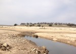
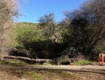
Looking toward Dyke 5 and rise of landscape that would trap water at its base.
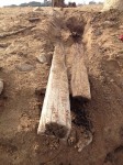
In 1862 the Sacramento Placer and Nevada Railroad wound its way from Ashland, north of Folsom, up towards Auburn. The route took the line around Beals Point, at that time known as Beals Bar, along the river and ran along the North Fork Ditch spur around the ridge. When the line was abandoned in 1864, the railroad grade became a road. Old topographical maps show a bridge over the North Fork Ditch to connect the old railroad grade to a dirt road just on the north side of the ditch. While I am not entirely certain, I did find old timbers in the approximate location that might have been used in the bridge.
A big cut to save fish?
Work on the Folsom dam dykes obliterated many historical roads, bridges and parts of the old water ditch. Consequently, it is difficult to determine what an original outline of the ditch or road is and what was grading from the construction of the dam. There is a deep cut that leads from Dyke 5 toward the river channel. It is possible that this cut was originally made next to or on top of the the railroad grade. When you look at the 1954 topographical map that includes elevation within the interior of the Folsom lake, you can see that the placement of Dyke 5 creates a large pond at its base because of elevation changes or the small saddle of landscape between the two ridges. I suspect the deep cut was made to allow fish to safely exit the inadvertent pond and not be trapped by low water levels.
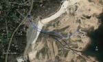
The puzzle pieces of dams and ditches fit
When I place an overlay of historic topographic maps on top of a low water Google Earth image of

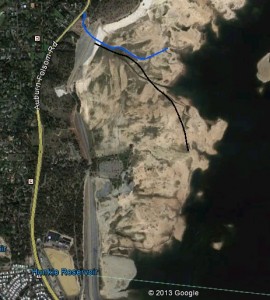
Possible routes of SPN RR and NFD spur on Google Earth image 2009
Folsom Lake from October 23, 2009, all of the map features of the North Fork Ditch and roads pretty much line up with the historic remnants in the photo. When either the North Fork or Rose Spring Ditch could not be excavated in the native terrain to maintain the gradient, they would build an earth berm on one side. If this earth berm is washed away, there is little trace of the ditch save for some possible concrete or unnaturally smooth flat ground. I have not been able to locate any concrete lining along the route of the North Fork Ditch spur. I am not sure if it was never lined, was washed away by rising lake levels or destroy by earth movers to build Folsom dam. Consequently, I have used the clues of nice flat lines coupled with historic topographic maps to approximate its path.
The overall value of this information is useful only to those of us gripped by unanswered historical questions or those wandering the landscape of Folsom Lake at low water levels wondering, “What was this concrete lined path for and who built it?”
So now you know that a great water project started in 1854 had a 100 year life span and was then eclipsed and abandoned by an even larger water project call the Folsom Dam. The legacy of the North Fork Ditch is that it allowed suburban growth to be extended outside of Sacramento into the areas of the Orangevale and Fair Oaks Colonies and Citrus Heights.


Click on thumbnails of pictures and images to enlarge. Pictures with numbers in from of description correspond to locations on the photo map thumbnails so you can see where it was taken.